45.232.3.124 - IP Lookup: Free IP Address Lookup, Postal Code Lookup, IP Location Lookup, IP ASN, Public IP
Country:
Region:
City:
Location:
Time Zone:
Postal Code:
IP information under different IP Channel
ip-api
Country
Region
City
ASN
Time Zone
ISP
Blacklist
Proxy
Latitude
Longitude
Postal
Route
Luminati
Country
Region
t
ASN
Time Zone
America/Argentina/Tucuman
ISP
SISTEMAS INFORMATICOS S.A.S. INTERFLASH
Latitude
Longitude
Postal
IPinfo
Country
Region
City
ASN
Time Zone
ISP
Blacklist
Proxy
Latitude
Longitude
Postal
Route
IP2Location
45.232.3.124Country
Region
tucuman
City
san miguel de tucuman
Time Zone
America/Argentina/Tucuman
ISP
Language
User-Agent
Latitude
Longitude
Postal
db-ip
Country
Region
City
ASN
Time Zone
ISP
Blacklist
Proxy
Latitude
Longitude
Postal
Route
ipdata
Country
Region
City
ASN
Time Zone
ISP
Blacklist
Proxy
Latitude
Longitude
Postal
Route
Popular places and events near this IP address

San Miguel de Tucumán
City in Tucumán, Argentina
Distance: Approx. 1040 meters
Latitude and longitude: -26.81666667,-65.21666667
San Miguel de Tucumán (Spanish pronunciation: [ˈsam miˈɣel de tukuˈman]), usually called simply Tucumán, is the capital and largest city of Tucumán Province, located in northern Argentina 1,311 kilometres (815 mi) from Buenos Aires. It is the fifth-largest city of Argentina after Buenos Aires, Córdoba, Rosario and Mendoza and the most important of the northern region. The Spanish conquistador Diego de Villarroel founded the city in 1565 in the course of an expedition from present-day Peru.
Saint Thomas Aquinas University of the North
Distance: Approx. 1923 meters
Latitude and longitude: -26.83277778,-65.20583333
The Universidad del Norte de Santo Tomás de Aquino (Saint Thomas Aquinas North University, UNSTA) is a Catholic university located in San Miguel de Tucumán, Tucumán province, Argentina.

Estadio La Ciudadela
Football stadium in Tucumán, Argentina
Distance: Approx. 1500 meters
Latitude and longitude: -26.83628056,-65.22960556
Estadio La Ciudadela is a football stadium located in the Ciudadela district of San Miguel de Tucumán, Argentina. Inaugurated in 1932, the stadium is owned and operated by C.A. San Martín and has a capacity 30,250 people.
Roman Catholic Archdiocese of Tucumán
Catholic ecclesiastical territory
Distance: Approx. 2073 meters
Latitude and longitude: -26.8316,-65.2035
The Roman Catholic Archdiocese of Tucumán (Latin: Archidioecesis Tucumanensis) is in Argentina and is a metropolitan diocese. Its suffragan sees include Añatuya, Concepción and Santiago del Estero.

Battle of Tucumán
Distance: Approx. 1567 meters
Latitude and longitude: -26.83741111,-65.21696111
The Battle of Tucumán was fought on 24 and 25 September 1812 near the Argentine city of San Miguel de Tucumán, during the Argentine War of Independence. The Army of the North, commanded by General Manuel Belgrano, defeated the royalist troops commanded by General Pío de Tristán, who had a two-to-one advantage in numbers, halting the royalist advance on Argentina's northwest. Together with the Battle of Salta, on 20 February 1813, the victory at Tucumán allowed the Argentine troops to reaffirm the borders under their control.
Tucumán Government Palace
Executive office building of the Government of the Province of Tucumán
Distance: Approx. 1854 meters
Latitude and longitude: -26.83027778,-65.20527778
The Tucumán Government Palace is the executive office building of the Government of the Province of Tucumán.
Timoteo Navarro Museum of Art
Distance: Approx. 1965 meters
Latitude and longitude: -26.83166667,-65.20472222
The Timoteo Navarro Provincial Museum of Fine Arts is the leading museum of its kind in Tucumán Province, Argentina.
Saint Paul-T University
Distance: Approx. 1040 meters
Latitude and longitude: -26.81666667,-65.21666667
The University of Saint Paul-T (abbreviation: USP-T) was created on July 4, 2007 by presidential decree. It was the first "secular private university" of Argentine Northwest and Argentina.

Tucumán Mitre railway station
Railway station in San Miguel de Tucumán, Argentina
Distance: Approx. 1322 meters
Latitude and longitude: -26.82,-65.2103
Tucumán is a train station in the city of San Miguel de Tucumán of Tucumán Province, Argentina, and terminus of Ferrocarril Mitre. The station was built and firstly operated by the Buenos Aires and Rosario Railway (BA&R) and then added to Ferrocarril Mitre network in 1948. It is currently operated by two companies: State-owned Trenes Argentinos (for passenger services) and private Nuevo Central Argentino (NCA) that runs freight trains on the line.

Tucumán Belgrano railway station
Railway station in San Miguel de Tucumán, Argentina
Distance: Approx. 789 meters
Latitude and longitude: -26.827394,-65.215554
Tucumán is a train station in the city of San Miguel de Tucumán of Tucumán Province, Argentina. The station was originally built and operated by the Córdoba Central Railway and then added to Belgrano Railway network. Nowadays the station is only used for freight services, being operated by state-owned company Trenes Argentinos Cargas .

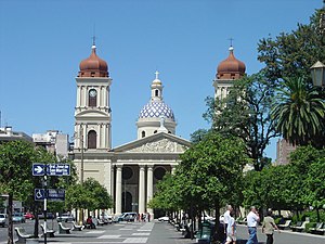
San Miguel de Tucumán Cathedral
Church in San Miguel de Tucumán, Argentina
Distance: Approx. 2074 meters
Latitude and longitude: -26.8314,-65.2034
The Our Lady of the Incarnation Cathedral (Spanish: Catedral de Nuestra Señora de la Encarnación de San Miguel de Tucumán) also called San Miguel de Tucumán Cathedral It is the mother church of the city of San Miguel de Tucuman, in the province of Tucuman, in the South American country of Argentina. The temple was founded in the sixteenth century and is home to the metropolitana Archdiocese of Tucuman. The foundations of this cathedral building date from the period of the definitive founding of the city of San Miguel de Tucuman in 1685, long remained a humble building adobes with gabled of "musleras tiles" then keeping some simple style details Hispanic American colonial baroque.

Yerba Buena Steam Tram
Distance: Approx. 1054 meters
Latitude and longitude: -26.81525,-65.21958
The Yerba Buena Steam Tram (Spanish: Tranvía Rural a Vapor de Yerba Buena, nicknamed Trencito or La Chorbita) was a 12 km (7.5 mi) long 600 mm (1 ft 11+5⁄8 in) gauge railway in the city of Yerba Buena in Tucumán Province. It was inaugurated on 29 June 1916 during the Centennial of the Argentine Independence and was shut down a decade later in 1926.
Weather in this IP's area
clear sky
33 Celsius
32 Celsius
33 Celsius
33 Celsius
1007 hPa
31 %
1007 hPa
945 hPa
10000 meters
1.54 m/s


