45.229.55.194 - IP Lookup: Free IP Address Lookup, Postal Code Lookup, IP Location Lookup, IP ASN, Public IP
Country:
Region:
City:
Location:
Time Zone:
Postal Code:
IP information under different IP Channel
ip-api
Country
Region
City
ASN
Time Zone
ISP
Blacklist
Proxy
Latitude
Longitude
Postal
Route
Luminati
Country
Region
sp
City
carapicuiba
ASN
Time Zone
America/Sao_Paulo
ISP
Paulino Perreira Dos Santos Eireli
Latitude
Longitude
Postal
IPinfo
Country
Region
City
ASN
Time Zone
ISP
Blacklist
Proxy
Latitude
Longitude
Postal
Route
IP2Location
45.229.55.194Country
Region
sao paulo
City
vila do conde
Time Zone
America/Sao_Paulo
ISP
Language
User-Agent
Latitude
Longitude
Postal
db-ip
Country
Region
City
ASN
Time Zone
ISP
Blacklist
Proxy
Latitude
Longitude
Postal
Route
ipdata
Country
Region
City
ASN
Time Zone
ISP
Blacklist
Proxy
Latitude
Longitude
Postal
Route
Popular places and events near this IP address

Barueri
Municipality in Southeast, Brazil
Distance: Approx. 2422 meters
Latitude and longitude: -23.51111111,-46.87638889
Barueri (Portuguese pronunciation: [bɐˌɾu.eˈɾi] or [baɾweˈɾi]) is a Brazilian municipality in the State of São Paulo located in the northwestern part of the Metropolitan Region of São Paulo. The population is 276,982 (2020 est.) in an area of 65.70 km2 (25.37 sq mi). Its boundaries are Santana de Parnaíba to the north, Osasco in the east, Carapicuíba in the Southeast, Jandira to the south and southwest, and Itapevi the west.

Carapicuíba
Municipality in São Paulo, Brazil
Distance: Approx. 3568 meters
Latitude and longitude: -23.51916667,-46.83583333
Carapicuíba (Portuguese pronunciation: [kaɾapikuˈibɐ]) is a municipality in the state of São Paulo in Brazil. It is part of the Metropolitan Region of São Paulo. The population is 403,183 (2020 est.) in an area of 34.55 square kilometres (13.34 sq mi).

Itapevi
Municipality in Southeast, Brazil
Distance: Approx. 7015 meters
Latitude and longitude: -23.54888889,-46.93416667
Itapevi is a Brazilian municipality in the state of São Paulo located in the western part of the Greater São Paulo metropolitan area (35 km to the west of São Paulo city). The population is 240,961 (2020 est.) in an area of 82.7 km2. Its boundaries are Santana de Parnaíba to the north, Barueri in the northeast, Jandira in the east, Cotia to the south, Vargem Grande Paulista to the southwest and São Roque to the west.

Jandira
Place in Southeast, Brazil
Distance: Approx. 3564 meters
Latitude and longitude: -23.52777778,-46.90277778
Jandira is a municipality in the state of São Paulo in Brazil. It is part of the Metropolitan Region of São Paulo. The population is 126,356 (2020 est.) in an area of 17.45 km2.

Alphaville, São Paulo
Real estate development in Brazil
Distance: Approx. 5009 meters
Latitude and longitude: -23.49166667,-46.84527778
Alphaville, Barueri (Portuguese pronunciation: [awfaˈvili]) is an affluent district split between the municipalities of Barueri and Santana de Parnaíba suburbs of São Paulo. The Alphaville district is a real estate and gated community development in Brazil, constituted by a number of business and residential condominium. The name evokes the "first among cities" concept (ville as French for city and alpha being the first letter of Greek alphabet).

Taboão da Serra
Municipality in Southeast, Brazil
Distance: Approx. 7009 meters
Latitude and longitude: -23.53277778,-46.79944444
Taboão da Serra is a municipality in the state of São Paulo in Brazil. It is part of the Metropolitan Region of São Paulo. The population is 293,652 (2020 est.) in an area of 20.39 km².

Arena Barueri
Multi-use stadium in Barueri, Brazil
Distance: Approx. 3801 meters
Latitude and longitude: -23.51305556,-46.89944444
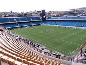
Arena Barueri is a multi-use stadium located in Barueri, São Paulo state, Brazil. It is used mostly for football matches and hosts the home matches of Oeste, and hosted the matches of Grêmio Recreativo Barueri until the 2010 season. The stadium has a maximum capacity of 31,452 people and was built in 2007.

Granja Viana
District in Cotia, São Paulo, Brazil
Distance: Approx. 7597 meters
Latitude and longitude: -23.59833333,-46.85305556
Granja Viana (commonly known as Granja, sometimes spelled as Granja Vianna) is an upscale district in the city of Cotia, São Paulo, Brazil. Officially, the district is located in the east side of the city, but some portions of southern Carapicuíba, northern Embu das Artes and eastern Jandira are often referred to as Granja Viana as well. It can be accessed via the Raposo Tavares Highway.
Cotia River
River in Brazil
Distance: Approx. 2478 meters
Latitude and longitude: -23.51666667,-46.85
The Cotia River is a river of São Paulo state in southeastern Brazil.
Ginásio José Corrêa
Indoor sporting arena in São Paulo, Brazil
Distance: Approx. 2703 meters
Latitude and longitude: -23.50722222,-46.8675
Ginásio Poliesportivo José Corrêa is an indoor sporting arena that is located in Barueri, São Paulo, Brazil. The capacity of the arena is 5,000 people for basketball and volleyball games.

Comandante Sampaio (CPTM)
Railway station in São Paulo, Brazil
Distance: Approx. 7423 meters
Latitude and longitude: -23.525756,-46.795637
Comandante Sampaio is a rail station belonging to ViaMobilidade Line 8-Diamond, located in the city of Osasco, in the Km 18 borough.

Quitaúna (CPTM)
Railway station in São Paulo, Brazil
Distance: Approx. 6300 meters
Latitude and longitude: -23.522785,-46.807112
Quitaúna is a train station, belonging to ViaMobilidade Line 8-Diamond, located in the municipality of Osasco.
Weather in this IP's area
broken clouds
21 Celsius
22 Celsius
20 Celsius
21 Celsius
1011 hPa
92 %
1011 hPa
919 hPa
10000 meters
3.66 m/s
6.62 m/s
131 degree
70 %