45.228.190.67 - IP Lookup: Free IP Address Lookup, Postal Code Lookup, IP Location Lookup, IP ASN, Public IP
Country:
Region:
City:
Location:
Time Zone:
Postal Code:
ISP:
ASN:
language:
User-Agent:
Proxy IP:
Blacklist:
IP information under different IP Channel
ip-api
Country
Region
City
ASN
Time Zone
ISP
Blacklist
Proxy
Latitude
Longitude
Postal
Route
db-ip
Country
Region
City
ASN
Time Zone
ISP
Blacklist
Proxy
Latitude
Longitude
Postal
Route
IPinfo
Country
Region
City
ASN
Time Zone
ISP
Blacklist
Proxy
Latitude
Longitude
Postal
Route
IP2Location
45.228.190.67Country
Region
misiones
City
obera
Time Zone
America/Argentina/Cordoba
ISP
Language
User-Agent
Latitude
Longitude
Postal
ipdata
Country
Region
City
ASN
Time Zone
ISP
Blacklist
Proxy
Latitude
Longitude
Postal
Route
Popular places and events near this IP address

Oberá
City in Misiones, Argentina
Distance: Approx. 1391 meters
Latitude and longitude: -27.48333333,-55.13333333
Oberá, formerly Svea, is a city in the interfluvial province of Misiones, Argentina, and the head town of the Oberá Department. It is located 96 km east of the provincial capital Posadas, on National Route 14, and about 1,150 km north of Buenos Aires. It has 63,960 inhabitants according to the 2010 census [INDEC].

Florentino Ameghino, Misiones
Municipality and village in Misiones Province, Argentina
Distance: Approx. 7126 meters
Latitude and longitude: -27.55,-55.13333333
Florentino Ameghino (Misiones) is a village and municipality in Misiones Province in north-eastern Argentina.
General Alvear, Misiones
Municipality and village in Misiones Province, Argentina
Distance: Approx. 8344 meters
Latitude and longitude: -27.42638889,-55.16944444
General Alvear (Misiones) is a village and municipality in Misiones Province in north-eastern Argentina.
Guaraní, Misiones
Municipality and village in Misiones Province, Argentina
Distance: Approx. 5671 meters
Latitude and longitude: -27.51666667,-55.16666667
Guaraní (Misiones) is a village and municipality in Misiones Province in north-eastern Argentina.
Los Helechos
Municipality and village in Misiones Province, Argentina
Distance: Approx. 8937 meters
Latitude and longitude: -27.5575,-55.07638889
Los Helechos is a village and municipality in Misiones Province in north-eastern Argentina.
Oberá Airport
Airport in Argentina
Distance: Approx. 3472 meters
Latitude and longitude: -27.51805556,-55.12416667
Oberá Airport (Spanish: Aeropuerto de Oberá, ICAO: SATO) is a public use airport serving Oberá, a city in the Misiones Province of Argentina. The airport is at the south edge of the city. The Posadas VOR-DME (Ident: POS) is located 45.7 nautical miles (85 km) west of the airport.
Oberá Cathedral
Church in Oberá, Argentina
Distance: Approx. 239 meters
Latitude and longitude: -27.485,-55.1194
The St. Anthony of Padua Cathedral (Spanish: Catedral de San Antonio de Padua de Oberá), also called Oberá Cathedral, is a Catholic cathedral under the advocacy of St. Anthony of Padua, located in the central area of the city of Oberá, in the province of Misiones, in the South American country of Argentina.

Autódromo Ciudad de Oberá
Distance: Approx. 5769 meters
Latitude and longitude: -27.49416667,-55.17777778
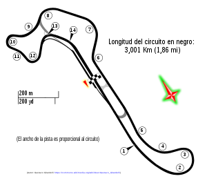
Autódromo Ciudad de Oberá is a motor racing circuit located on the outskirts of the homonymous city, in Misiones Province, Argentina. It is a circuit that popularly receives national-level motorsport categories, possessing two circuit variants, the first (more extensive) is a 4.380 km (2.722 mi) circuit, with an appendix formed by a straight with an extensive curve and a final counter-straight. The main straight and a group of locked corners close the circuit.

Autódromo Ciudad de Pigüé
Motor racing circuit in Argentina
Distance: Approx. 5769 meters
Latitude and longitude: -27.49416667,-55.17777778
Autódromo Ciudad de Pigüé is a motor racing circuit located near Pigüé, in Buenos Aires Province, Argentina. It is a circuit that has hosted competitions Turismo Nacional, TC2000 and TC de Sudoeste. Circuit No.
Weather in this IP's area
overcast clouds
19 Celsius
19 Celsius
19 Celsius
19 Celsius
1008 hPa
98 %
1008 hPa
975 hPa
10000 meters
2.12 m/s
4.92 m/s
348 degree
94 %


