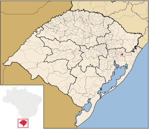
Country:
Region:
City:
Latitude and Longitude:
Time Zone:
Postal Code:
IP information under different IP Channel
ip-api
Country
Region
City
ASN
Time Zone
ISP
Blacklist
Proxy
Latitude
Longitude
Postal
Route
Luminati
Country
Region
rs
City
igrejinha
ASN
Time Zone
America/Sao_Paulo
ISP
CLICKCONNECT SOLUCOES EM INTERNET E TECNOLOGIA
Latitude
Longitude
Postal
IPinfo
Country
Region
City
ASN
Time Zone
ISP
Blacklist
Proxy
Latitude
Longitude
Postal
Route
db-ip
Country
Region
City
ASN
Time Zone
ISP
Blacklist
Proxy
Latitude
Longitude
Postal
Route
ipdata
Country
Region
City
ASN
Time Zone
ISP
Blacklist
Proxy
Latitude
Longitude
Postal
Route
Popular places and events near this IP address

Igrejinha
Place in South, Brazil
Distance: Approx. 2332 meters
Latitude and longitude: -29.57388889,-50.79
Igrejinha (Portuguese pronunciation: [igɾe'ʒiɲɐ] — little church in Portuguese) is a municipality located in the metropolitan area of Porto Alegre, in the state of Rio Grande do Sul, Brazil. Home to the Morro Alto da Pedra and the regional park Parque Alto da Pedra. The city has approximately 37,000 inhabitants and sits about 82 km (about 51 miles) from the capital city of the state, Porto Alegre.

Três Coroas
Municipality in Rio Grande do Sul, Brazil
Distance: Approx. 5130 meters
Latitude and longitude: -29.51527778,-50.77944444
Três Coroas is a municipality in Brazil, located in the state of Rio Grande do Sul. Its population is estimated at 28,581 (2020).

Parobé
Municipality in Rio Grande do Sul, Brazil
Distance: Approx. 9777 meters
Latitude and longitude: -29.62888889,-50.835
Parobé is a municipality in the state of Rio Grande do Sul, Brazil.
Weather in this IP's area
clear sky
29 Celsius
29 Celsius
29 Celsius
29 Celsius
1011 hPa
42 %
1011 hPa
975 hPa
10000 meters
3.12 m/s
3.41 m/s
172 degree
7 %
05:18:24
18:58:37