45.221.211.108 - IP Lookup: Free IP Address Lookup, Postal Code Lookup, IP Location Lookup, IP ASN, Public IP
Country:
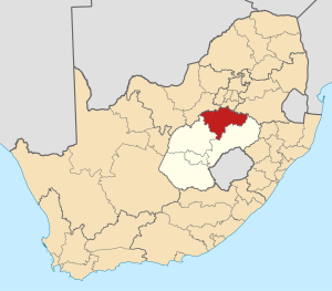
 South Africa
Region:
City:
Location:
Time Zone:
Postal Code:
ISP:
ASN:
language:
User-Agent:
Proxy IP:
Blacklist:
IP information under different IP Channel
ip-api
Country
Region
City
ASN
Time Zone
ISP
Blacklist
Proxy
Latitude
Longitude
Postal
Route
db-ip
Country
Region
City
ASN
Time Zone
ISP
Blacklist
Proxy
Latitude
Longitude
Postal
Route
IPinfo
Country
Region
City
ASN
Time Zone
ISP
Blacklist
Proxy
Latitude
Longitude
Postal
Route
IP2Location
45.221.211.108Country
zaRegion
free state
City
sasolburg
Time Zone
Africa/Johannesburg
ISP
Language
User-Agent
Latitude
Longitude
Postal
ipdata
Country
Region
City
ASN
Time Zone
ISP
Blacklist
Proxy
Latitude
Longitude
Postal
Route
Popular places and events near this IP address

Sasolburg
Place in Free State, South Africa
Distance: Approx. 1165 meters
Latitude and longitude: -26.81416667,27.82861111
Sasolburg is a city in the Free State province of South Africa. The city is located in the northern part of the province and is the seat of the Metsimaholo Local Municipality. The city lies 13 kilometres south of the Gauteng province and forms part of the Vaal Triangle (Vanderbijlpark, Vereeniging and Sasolburg) region.
Flavius Mareka FET College
Distance: Approx. 2300 meters
Latitude and longitude: -26.81695,27.83974
Flavius Mareka FET College is situated in the Fezile Dabi District of the Free State Province, South Africa. The Flavius Mareka FET College includes the following former institutions: Kroonstad - Mphohadi - and Sasolburg Campus.
Fezile Dabi District Municipality
District municipality in Free State, South Africa
Distance: Approx. 342 meters
Latitude and longitude: -26.81666667,27.81666667
The Fezile Dabi District Municipality (Sotho: Masepala wa Setereke wa Fezile Dabi; Afrikaans: Fezile Dabi-distriktsmunisipaliteit), formerly known as the Northern Free State District Municipality, is one of the 5 districts of the Free State province of South Africa. The seat is Sasolburg. As of 2011, a majority of its 460,289 residents spoke Sesotho.
Sasolburg High School
Public high school in Sasolburg, South Africa
Distance: Approx. 505 meters
Latitude and longitude: -26.80916667,27.81583333
Sasolburgh High School is a public high school, serving grades 8 to 12, in the town of Sasolburg, South Africa.
Flavius Mareka Sports Ground
Distance: Approx. 2316 meters
Latitude and longitude: -26.8164,27.84
Flavius Mareka Sports Grounds is a multi-use stadium in Sasolburg, Free State, South Africa.
Zamdela Stadium
Distance: Approx. 4710 meters
Latitude and longitude: -26.8475,27.84527778
Zamdela Stadium is a multi-use stadium in Sasolburg, Free State, South Africa. It is currently used mostly for football matches and is the home ground of Free State Champs.

Metsimaholo Local Municipality
Local municipality in Free State, South Africa
Distance: Approx. 346 meters
Latitude and longitude: -26.8167,27.8167
Metsimaholo Municipality (Sotho: Masepala wa Metsimaholo; Afrikaans: Metsimaholo Munisipaliteit) is a local municipality within the Fezile Dabi District Municipality, in the Free State province of South Africa. Metsimaholo means "big water" in Sesotho.
Coalbrook mining disaster
1960 mineshaft collapse at Clydesdale Colliery, South Africa
Distance: Approx. 7575 meters
Latitude and longitude: -26.8531,27.879
The Coalbrook mining disaster is the worst mining accident in the history of South Africa. The disaster occurred in the Coalbrook coal mine of Clydesdale Colliery on 21 January 1960 at around 19:00 when approximately 900 pillars caved in, almost 180 metres (590 ft) underground. The mine is situated in the Northern Free State, 21 kilometres (13 mi) south west of Vereeniging.

Tsogo Sun
Entertainment company headquartered in South Africa
Distance: Approx. 8870 meters
Latitude and longitude: -26.74274,27.85771
Tsogo Sun is a South African gaming, hotels and entertainment group. Tsogo Sun operates 15 casinos, 24 Galaxy Bingo sites, 1 Independent Site Operator Licence (ISO) as well as VSlots ("LPMs") Limited Pay-out Machines across nine provinces, including but not limited to Bet.co.za bookmaker licences, hotels, a theme park, theatres, movie cinemas, restaurants, bars and conference facilities. Tsogo Sun means 'resurrection' or 'new life' – a term that mimics the daily rising of the sun in Setswana.
Emerald Resort & Casino
South African hotel and casino
Distance: Approx. 8870 meters
Latitude and longitude: -26.74274,27.85771
Emerald Resort & Casino is a hotel and casino located at a private estate on the banks of the Vaal River in Vanderbijlpark, South Africa. The casino opened in 1997.
Weather in this IP's area
broken clouds
27 Celsius
27 Celsius
27 Celsius
27 Celsius
1010 hPa
41 %
1010 hPa
856 hPa
10000 meters
0.97 m/s
2.1 m/s
98 degree
75 %