Country:
Region:
City:
Latitude and Longitude:
Time Zone:
Postal Code:
IP information under different IP Channel
ip-api
Country
Region
City
ASN
Time Zone
ISP
Blacklist
Proxy
Latitude
Longitude
Postal
Route
Luminati
Country
ASN
Time Zone
Africa/Conakry
ISP
GUILAB-AS
Latitude
Longitude
Postal
IPinfo
Country
Region
City
ASN
Time Zone
ISP
Blacklist
Proxy
Latitude
Longitude
Postal
Route
db-ip
Country
Region
City
ASN
Time Zone
ISP
Blacklist
Proxy
Latitude
Longitude
Postal
Route
ipdata
Country
Region
City
ASN
Time Zone
ISP
Blacklist
Proxy
Latitude
Longitude
Postal
Route
Popular places and events near this IP address

French Guinea
French colony in West Africa (1891-1958); now the country of Guinea
Distance: Approx. 35 meters
Latitude and longitude: 9.5092,-13.7122
French Guinea (French: Guinée française) was a French colonial possession in West Africa. Its borders, while changed over time, were in 1958 those of the current independent nation of Guinea. French Guinea was established by France in 1891, within the same borders as its previous colony known as Rivières du Sud (1882–1891).

Conakry
Capital and largest city of Guinea
Distance: Approx. 36 meters
Latitude and longitude: 9.50916667,-13.71222222
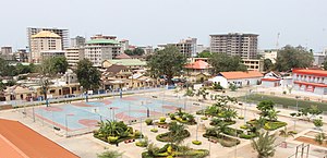
Conakry ( KON-ə-kree, French: [kɔnakʁi]; Susu: Kɔnakiri; N'Ko: ߞߐߣߊߞߙߌ߫, romanized: Kɔnakrí; Fula: 𞤑𞤮𞤲𞤢𞥄𞤳𞤭𞤪𞤭, romanized: Konaakiri{{langx}} uses deprecated parameter(s) ) is the capital and largest city of Guinea. A port city, it serves as the economic, financial and cultural centre of Guinea. Its population as of the 2014 Guinea census was 1,660,973.
Central Bank of the Republic of Guinea
Monetary Authority of Guinea
Distance: Approx. 286 meters
Latitude and longitude: 9.5098,-13.7144
The Central Bank of the Republic of Guinea (French: Banque Centrale de la République de Guinée, BCRG; N'Ko: ߖߌ߬ߣߍ߫ ߞߊ߲ߓߍ߲ ߕߊ߲ߓߊ߲ ߜߍߓߏ߲) is the central bank of Guinea. The headquarters of the bank is located in the capital city of Conakry. The current governor is Dr Karamo Kaba.

Tombo Island
Distance: Approx. 232 meters
Latitude and longitude: 9.51,-13.71
Tombo Island is an island in the Atlantic Ocean at the tip of the Guinean Kaloum Peninsula, approximately 4 km (2.5 mi) east of the Loos Islands. The island is the site where the capital Conakry was built on. It is the site of the old city of Conakry while the new colonial city is located at Kaloum.

Roman Catholic Archdiocese of Conakry
Latin Catholic jurisdiction in Guinea
Distance: Approx. 435 meters
Latitude and longitude: 9.5102,-13.7157
The Archdiocese of Conakry (Latin: Konakrien(sis)) is a Latin Church ecclesiastical territory or archdiocese of the Catholic Church in Guinea. It is the metropolitan see for its ecclesiastical province which covers all Guinea. It depends upon the Congregation for the Evangelization of Peoples.

Kaloum
Sub-prefecture in Conakry Region, Guinea
Distance: Approx. 36 meters
Latitude and longitude: 9.50916667,-13.71222222
Kaloum is an urban sub-prefecture in the Conakry Region of Guinea and one of five in the capital Conakry. Kaloum includes the city centre of Conakry. As of 2014 it had a population of 62,675 people.

Grand Hotel de L'Independance
Hotel in Conakry, Guinea
Distance: Approx. 829 meters
Latitude and longitude: 9.505858,-13.718705
The Grand Hotel de L'Independance (or Hotel GHI), formerly the Hotel de France, is a hotel in downtown Conakry, Guinea. The hotel was first opened in 1954 as the Hotel de France, with a modernistic design for the time. It was renamed the Grand Hotel de L'Independance when Guinea gained independence in 1958.

Sandervalia National Museum
National museum
Distance: Approx. 583 meters
Latitude and longitude: 9.504702,-13.709003
The Sandervalia National Museum (French: Musée national de Sandervalia) is the national museum of Guinea, situated in the capital, Conakry. Most of the rooms are empty, but it contains a limited display of traditional objects from different regions of Guinea, as well as objects and statues from the colonial era. Various craft items are for sale.

St. Mary's Cathedral, Conakry
Distance: Approx. 423 meters
Latitude and longitude: 9.510217,-13.715583
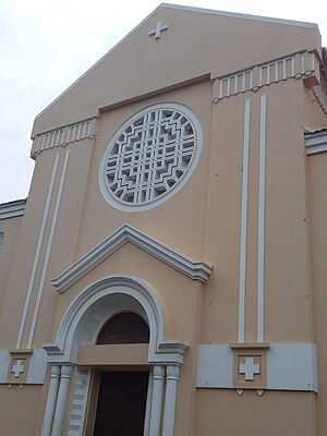
The Cathédrale Sainte-Marie is an important place of Christian worship in Conakry, Guinea. The yellow and red building is of considerable architectural interest. Monseigneur Raymond René Lérouge laid the foundation stone of the Cathedral in 1928.
Presidential Palace, Conakry
Distance: Approx. 619 meters
Latitude and longitude: 9.51014,-13.717439
The Sekhoutoureah Presidential Palace (French: Palais présidentiel Sekhoutoureah) in Conakry, Guinea, is the official residence of the president of Guinea. The Palais Presidentiel Sekhoutoureah is behind the Cathédrale Sainte-Marie.
Ignace Deen Hospital
Hospital in Conakry, Guinea
Distance: Approx. 799 meters
Latitude and longitude: 9.5068,-13.705
The Ignace Deen Hospital (Hôpital Ignace Deen) is a hospital in Conakry, Guinea built during the colonial era. The hospital is situated next to the National Museum. A report in 2011 described the conditions as squalid, with poor quality of care.
Marché du Niger
Market in Conakry, Guinea
Distance: Approx. 510 meters
Latitude and longitude: 9.51055556,-13.7075
Marché du Niger (Nigerian market) is a market in Conakry, Guinea, slightly smaller than the other main market in the city, Marché Madina. It sells fruits and vegetables but reportedly has an issue with pickpocketing.
Weather in this IP's area
light rain
31 Celsius
38 Celsius
31 Celsius
31 Celsius
1009 hPa
70 %
1009 hPa
1008 hPa
10000 meters
4.12 m/s
270 degree
40 %
06:49:22
18:30:16