Country:
Region:
City:
Latitude and Longitude:
Time Zone:
Postal Code:
IP information under different IP Channel
ip-api
Country
Region
City
ASN
Time Zone
ISP
Blacklist
Proxy
Latitude
Longitude
Postal
Route
Luminati
Country
Region
ma
City
puntaarenas
ASN
Time Zone
America/Punta_Arenas
ISP
APOAPSIS SPA
Latitude
Longitude
Postal
IPinfo
Country
Region
City
ASN
Time Zone
ISP
Blacklist
Proxy
Latitude
Longitude
Postal
Route
db-ip
Country
Region
City
ASN
Time Zone
ISP
Blacklist
Proxy
Latitude
Longitude
Postal
Route
ipdata
Country
Region
City
ASN
Time Zone
ISP
Blacklist
Proxy
Latitude
Longitude
Postal
Route
Popular places and events near this IP address

Magallanes Region
First-level administrative division of Chile
Distance: Approx. 2479 meters
Latitude and longitude: -53.16666667,-70.93333333
The Magallanes Region (locally [maɣaˈʝanes]), officially the Magallanes y la Antártica Chilena Region (Spanish: Región de Magallanes y de la Antártica Chilena), is one of Chile's 16 first order administrative divisions. It is the southernmost, largest, and second least populated region of Chile. It comprises four provinces: Última Esperanza, Magallanes, Tierra del Fuego, and Antártica Chilena.

University of Magallanes
University in Punta Arenas, Chile
Distance: Approx. 2649 meters
Latitude and longitude: -53.13694444,-70.87972222
University of Magallanes (UMAG) is a university in the southern Chilean city of Punta Arenas. It is a public state university and it is part of the Chilean Traditional Universities. The University of Magallanes was established in 1981 during the neoliberal reforms of the Chile's military regime as the successor of Universidad Técnica del Estado's Punta Arenas section.

Punta Arenas
City in Magallanes y Antártica Chilena, Chile
Distance: Approx. 2479 meters
Latitude and longitude: -53.16666667,-70.93333333
Punta Arenas (Spanish pronunciation: [ˈpunta aˈɾenas], historically known as Sandy Point in English) is the capital city of Chile's southernmost region, Magallanes and Antarctica Chilena. Although officially renamed as Magallanes in 1927, the name was changed back to Punta Arenas in 1938. The city is the largest south of the 46th parallel south and the most populous southernmost city in Chile and the Americas.
Magallanes Province
Province in Magallanes y Antártica Chilena, Chile
Distance: Approx. 2479 meters
Latitude and longitude: -53.16666667,-70.93333333
Magallanes Province (Spanish: Provincia de Magallanes) is one of four provinces in the southern Chilean region of Magallanes and Antártica Chilena. The provincial capital is the city of Punta Arenas.

Instituto Antártico Chileno
Chilean public service institution
Distance: Approx. 1864 meters
Latitude and longitude: -53.16307,-70.90719
The Chilean Antarctic Institute, known as INACH (Instituto Antártico Chileno), is a public service institution in charge of managing and coordinating scientific activities in the Chilean Antarctic Territory. It is the national Antarctic operator and has an active role in Antarctic affairs. It was created by the Chilean government on September 10, 1963, and since 2003 it has had its main headquarters in Punta Arenas, capital of the Magallanes Region and Chilean Antarctica.

Magallanes National Reserve
Distance: Approx. 5850 meters
Latitude and longitude: -53.1461,-71.0032
Magallanes National Reserve (Spanish: Reserva Nacional Magallanes) is a national reserve of southern Chile's Magallanes and Antártica Chilena Region. It was created on February 13, 1932.
Cemetery of Punta Arenas
Cemetery in Chile
Distance: Approx. 1364 meters
Latitude and longitude: -53.15277778,-70.8975
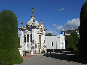
Cemetery of Punta Arenas Sara Braun is the public cemetery of the city of Punta Arenas, Chile. It is established on four hectares and is located in the northern area of the city, in Bulnes Avenue, between the streets Francisco Bilbao and Angamos. There are three entrances: the main entrance is in Bulnes Avenue, and two other entrances are in Francisco Bilbao and Angamos streets.

County of Peebles (ship)
Four-masted, iron-hulled full-rigged ship
Distance: Approx. 3329 meters
Latitude and longitude: -53.17698,-70.91746
The County of Peebles was the world's first four-masted, iron-hulled full-rigged ship. It was built during 1875, by Barclay Curle Shipbuilders in Glasgow, Scotland, for the shipping company R & J Craig of Glasgow. Measuring 81.2 metres (266 ft 5 in) long, with a beam of 11.8 metres (38 ft 9 in), a draught of 7.1 metres (23 ft 4 in) and a cargo capacity of 1,614 net register tons (NRT), it was a state-of-the-art windjammer when it began its use, for the jute trade between the ports of Dundee and Cardiff in Great Britain and Bombay and Calcutta / Hooghly River in East India.
Estadio Municipal Antonio Ríspoli Díaz
Distance: Approx. 1548 meters
Latitude and longitude: -53.15405278,-70.89551667
The Estadio Fiscal Antonio Rispoli Diaz is a stadium located in Punta Arenas, Chile. It has a capacity for 4,500 spectators.

Museo Nao Victoria
Maritime museum in Punta Arenas, Chile
Distance: Approx. 4996 meters
Latitude and longitude: -53.10768,-70.879832
The Nao Victoria Museum is a private maritime museum located in Punta Arenas, Chile. It has been open to the public since 1 October 2011. The museum offers interactive displays featuring replicas of the ships that contributed to the discovery of the area, helped colonize the territory, or had a special and historic heritage significance for the Magallanes Region of Chile.
Liceo María Auxiliadora
High school
Distance: Approx. 1639 meters
Latitude and longitude: -53.16053,-70.90554
Liceo María Auxiliadora (English: Mary Help of Christians High School) is a Chilean high school located in Santa Cruz, Colchagua Province, Chile. The school opened its doors in March 1889, with an enrollment of 13 students under the direction of Mother Angela Vallese.

Sacred Heart Cathedral, Punta Arenas
Church in Punta Arenas, Chile
Distance: Approx. 1716 meters
Latitude and longitude: -53.162,-70.909
The Sacred Heart Cathedral Cathedral (Spanish: Catedral del Sagrado Corazón) also called Punta Arenas Cathedral and Sacred Heart of Jesus Parish, is a religious building of the Catholic Church which has a Renaissance tower that is dedicated to the order of the Salesians. Its construction began on December 28, 1892, on the plans made by the Father of the Salesian order Juan Bernabe. It is located in the city of Punta Arenas in the region of Magallanes and Chilean Antarctica in the South American country of Chile.
Weather in this IP's area
light rain
12 Celsius
11 Celsius
12 Celsius
13 Celsius
990 hPa
50 %
990 hPa
986 hPa
10000 meters
3.09 m/s
80 degree
05:36:26
21:20:08

