Country:
 Peru
PeruRegion:
City:
Latitude and Longitude:
Time Zone:
Postal Code:
IP information under different IP Channel
ip-api
Country
Region
City
ASN
Time Zone
ISP
Blacklist
Proxy
Latitude
Longitude
Postal
Route
IPinfo
Country
Region
City
ASN
Time Zone
ISP
Blacklist
Proxy
Latitude
Longitude
Postal
Route
MaxMind
Country
Region
City
ASN
Time Zone
ISP
Blacklist
Proxy
Latitude
Longitude
Postal
Route
Luminati
Country
PERegion
lma
City
lima
ASN
Time Zone
America/Lima
ISP
SOFTBUTTERFLY SAC
Latitude
Longitude
Postal
db-ip
Country
Region
City
ASN
Time Zone
ISP
Blacklist
Proxy
Latitude
Longitude
Postal
Route
ipdata
Country
Region
City
ASN
Time Zone
ISP
Blacklist
Proxy
Latitude
Longitude
Postal
Route
Popular places and events near this IP address

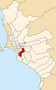
Chorrillos District
District in Lima, Peru
Distance: Approx. 2992 meters
Latitude and longitude: -12.18638889,-77.02111111
Chorrillos is a district of the Lima Province in Peru and part of the city of Lima. It gets its name from the Spanish word for "trickle of water". The district was founded as San Pedro de los Chorrillos and served as a deluxe beach resort until the late 19th century, when it was almost completely destroyed by Chilean forces during the War of the Pacific.
Santiago de Surco
District of Lima, Peru
Distance: Approx. 2390 meters
Latitude and longitude: -12.15,-77.01666667
Santiago de Surco, commonly known simply as Surco, is a district of Lima, Peru. It is bordered on the north with the district of Ate Vitarte and La Molina; on the east with San Juan de Miraflores, on the west with San Borja, Surquillo, Miraflores and Barranco, and on the south with Chorrillos. Due to its relatively large area, it is a very heterogeneous district, having inhabitants belonging to all socio-economic levels.

Barranco District
District in Lima, Peru
Distance: Approx. 3036 meters
Latitude and longitude: -12.14166667,-77.01666667
Barranco, founded in 1874 as San José de Surco, is one of 43 districts in Lima, Peru. Its current mayor is Jessica Vargas. The district is considered to be the city's most romantic and bohemian, being the home and working place of many of Peru's leading artists, musicians, designers and photographers.

Chorrillos Military School
Distance: Approx. 1733 meters
Latitude and longitude: -12.1619,-77.0184
The Chorrillos Military School (Spanish: Escuela Militar de Chorrillos) is the institution in charge of the undergraduate education of officers of the Peruvian Army.

Cristo del Pacífico
Distance: Approx. 1396 meters
Latitude and longitude: -12.17416667,-77.02888889
Cristo del Pacífico, "the Christ of the Pacific", is a 37-metre-high (121 ft) statue of Jesus erected in Lima, Peru, in 2011. Its erection was a gift from a consortium of Brazilian companies to the city of Lima, under former President Alan García, and described as a parting gift to the nation on occasion of his leaving office after the 2011 presidential election. It was inspired by the Christ the Redeemer statue in Rio de Janeiro.

Morro Solar
Distance: Approx. 2327 meters
Latitude and longitude: -12.182,-77.02583333
Morro Solar (morro in Spanish means: a rounded promontory) is a headland, situated in the district of Chorrillos, to the south of Lima, Peru.: 3, 842 Morro Solar is notable for being a site of the Battle of San Juan and Chorrillos between Peruvian and Chilean forces in 1881. Notable landmarks include an astronomical observatory and a monument to an unknown soldier. Its geological formations are rich in silver which is being extracted by several mining companies.
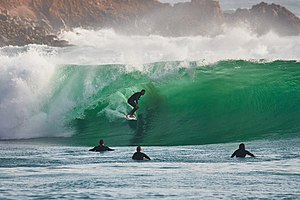
La Herradura, Lima
Beach in Peru
Distance: Approx. 1271 meters
Latitude and longitude: -12.1742,-77.0337
La Herradura is a beach located in the Chorrillos District of Lima, Peru. It has been used as a balneario since the beginning of the 20th century and for surfing since the 1960s. Until the 1980s it was one of the most popular beaches in Lima, visited especially by the city's wealthy families.

Hermitage of Barranco
Church in Peru
Distance: Approx. 1947 meters
Latitude and longitude: -12.14914,-77.02312
The Hermitage of Barranco (Spanish: Ermita de Barranco), formerly known as the Templo de la Santísima Cruz and later as Santísima Cruz de Barranco, is a Catholic church building in Barranco District, Lima, Peru. It is located in the district's historic centre and once served as the district's capital and cathedral, next to the Bridge of Sighs, and has been closed since 1974 due to the damages caused by that year's earthquake. The Plazuela Chabuca Granda, named after the Peruvian singer who dedicated a song to the bridge, serves as the main public area outside the church and features two statues by sculptor Fausto Jaulis dedicated to Granda and José Antonio de Lavalle y García, the subject of another song of hers.

Monument to Chabuca Granda
Monument in Peru
Distance: Approx. 1991 meters
Latitude and longitude: -12.14892,-77.02276
The Monument to Chabuca Granda (Spanish: Monumento a Chabuca Granda) is a monument made up by a pair of stone statues located at the Plazuela Chabuca Granda in Barranco District dedicated to Peruvian singer-songwriter Chabuca Granda. Next to Granda's statue is an equestrian statue of José Antonio de Lavalle y García, the subject of Granda's song José Antonio.

José Castro Mendivil Digital Planetarium
Planetarium in Peru
Distance: Approx. 728 meters
Latitude and longitude: -12.16929,-77.03348
José Castro Mendivil Digital Planetarium (Spanish: Planetario Digital José Castro Mendivil), also known simply as the Morro Solar Planetarium (Spanish: Planetario del Morro Solar), is a planetarium and site museum dedicated to astronomy in the Morro Solar of Chorrillos District, Lima, Peru. It is named after the engineer who designed it. It is administered by the Peruvian Astronomy Association (Spanish: Asociación Peruana de Astronomía, APA), founded on August 15, 1946, and then headed by Peruvian astronomer Víctor Estremadoyro Robles.

Monument to the Unknown Soldier, Lima
Monument in Lima, Peru
Distance: Approx. 1074 meters
Latitude and longitude: -12.17184,-77.03085
The Monument to the Unknown Soldier is a memorial located on a plain on the slopes of the northern side of Morro Solar in the district of Chorrillos, in Lima, Peru. It is dedicated to those killed during the War of the Pacific.
Luis Gálvez Chipoco Stadium
Stadium in Peru
Distance: Approx. 2990 meters
Latitude and longitude: -12.1381,-77.0235
Luis Gálvez Chipoco Stadium (Spanish: Estadio Luis Gálvez Chipoco) is a multi-purpose stadium in Barranco, Lima, Peru. It is also known as Parque Confraternidad, the name of the public park located there prior to its construction that partially served as the location of Barranco Zoo (Spanish: Zoológico de Barranco), the district's zoo from 1947 until its closure in 1970, when its animals were moved to the Parque de las Leyendas in San Miguel.
Weather in this IP's area
overcast clouds
17 Celsius
17 Celsius
16 Celsius
17 Celsius
1013 hPa
86 %
1013 hPa
1013 hPa
8000 meters
4.12 m/s
180 degree
100 %
05:59:28
18:04:08