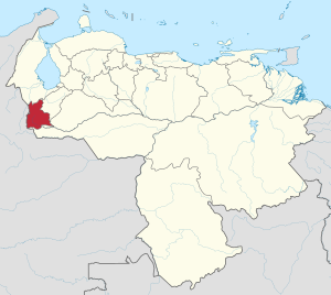
Country:
Region:
City:
Latitude and Longitude:
Time Zone:
Postal Code:
IP information under different IP Channel
ip-api
Country
Region
City
ASN
Time Zone
ISP
Blacklist
Proxy
Latitude
Longitude
Postal
Route
Luminati
Country
Region
s
City
sancristobal
ASN
Time Zone
America/Caracas
ISP
INFINITICS S.A.
Latitude
Longitude
Postal
IPinfo
Country
Region
City
ASN
Time Zone
ISP
Blacklist
Proxy
Latitude
Longitude
Postal
Route
db-ip
Country
Region
City
ASN
Time Zone
ISP
Blacklist
Proxy
Latitude
Longitude
Postal
Route
ipdata
Country
Region
City
ASN
Time Zone
ISP
Blacklist
Proxy
Latitude
Longitude
Postal
Route
Popular places and events near this IP address

San Cristóbal, Táchira
Place in Táchira, Venezuela
Distance: Approx. 1155 meters
Latitude and longitude: 7.76666667,-72.23333333
San Cristóbal (Spanish pronunciation: [saŋ kɾisˈtoβal]) is the capital city of the Venezuelan state of Táchira. It is located in a mountainous region of Western Venezuela. The city is situated 818 metres (2,684 ft) above sea level in the northern Andes overlooking the Torbes River, 56 kilometres (35 mi) from the Colombian border.

Estadio Polideportivo de Pueblo Nuevo
Distance: Approx. 3782 meters
Latitude and longitude: 7.78638889,-72.19777778
Estadio Polideportivo de Pueblo Nuevo is a multi-purpose stadium in San Cristóbal, Venezuela. It is currently used mostly for football matches and is the home stadium of Deportivo Táchira Fútbol Club. The stadium holds 38,755 people.

Plaza Monumental de Toros de Pueblo Nuevo
Bullring in San Cristóbal, Venezuela
Distance: Approx. 3589 meters
Latitude and longitude: 7.787853,-72.201741
Plaza Monumental de toros de Pueblo Nuevo is a Bullring in San Cristóbal, Venezuela, currently used for bullfighting. The stadium can hold up to 15,000 people and was built in 1967.

Andean Region, Venezuela
Distance: Approx. 1690 meters
Latitude and longitude: 7.75,-72.2167
The Andean Region is one of the 10 administrative regions in which Venezuela was divided for its development plans in 1969.
Táriba
City in Táchira, Venezuela
Distance: Approx. 5941 meters
Latitude and longitude: 7.81666667,-72.21666667
Táriba is a town in Táchira, Venezuela, and is the capital of the Cárdenas Municipality. It was founded in 1602. Táriba has a population of 128,590.
Palmira, Táchira
Place
Distance: Approx. 8631 meters
Latitude and longitude: 7.84055556,-72.23361111
Palmira is a town in Táchira, Venezuela. It is the capital of Guásimos Municipality. It was founded in 1627 by Fernando Saavedra and in 1642 by Captain Luis Sosa Lovera.

Táchira helicopter crash
Helicopter crash in Venezuela
Distance: Approx. 1155 meters
Latitude and longitude: 7.76666667,-72.23333333
The Táchira helicopter crash was the loss of a Venezuela Army helicopter and its 17 occupants on 3 May 2009.

Cathedral of St. Christopher, San Cristóbal
Church in San Cristóbal, Venezuela
Distance: Approx. 1334 meters
Latitude and longitude: 7.76495,-72.23533
The Cathedral of St. Christopher (Spanish: Catedral de San Cristóbal) It is a religious building belonging to the Catholic Church and is located at 5 with race 3 at one side of the Juan Maldonado Square, of the town of San Cristóbal in the municipality of San Cristóbal, Táchira State in the Andean region South American country of Venezuela. Not to be confused with another cathedral dedicated to the same saint but located in the city of Barcelona, Anzoátegui State.

Paramillo Airport
Airport
Distance: Approx. 4767 meters
Latitude and longitude: 7.80138889,-72.20277778
Paramillo Airport (IATA: SCI, ICAO: SVPM) is an airport serving San Cristóbal, the capital of the Táchira state of Venezuela. The runway is in Paramillo, 4 kilometres (2.5 mi) north of San Cristóbal. The Paramillo non-directional beacon (Ident: PRM) is located on the field.

Catholic University of Tachira
Jesuit, catholic school in Calle Jose Gregorio Hernandez, San Cristóbal, Táchira, Venezuela
Distance: Approx. 2939 meters
Latitude and longitude: 7.78985278,-72.22696944
Catholic University of Tachira (Universidad Católica del Táchira – UCAT) in San Cristobal, capital of Táchira state in Venezuela, originated in 1962 as an extension of Andrés Bello Catholic University of the Society of Jesus.

Chorro El Indio National Park
Distance: Approx. 6430 meters
Latitude and longitude: 7.75,-72.16666667
The Chorro El Indio National Park (Spanish: Parque nacional Chorro El Indio) Is a national park of Venezuela located to the east of San Cristóbal, Táchira State, in the mountain range the Maravilla, has access by the highway San Cristóbal - Macanillo - Potosí. The area includes the paramos of Guarín, El Pino, El Moradeño, El Moraleño, El Oso, Cerro La Maravilla and Cerro El Chimborazo, within which are the waterfalls Chorro El Indio and Chorro El Franklin, at the headwaters of the river Zúñiga. It reached the rank of National Park by decree dated December 7, 1989 by the then president of the republic Carlos Andrés Pérez.
Abra de Río Frío Natural Monument
Distance: Approx. 803 meters
Latitude and longitude: 7.76666667,-72.21666667
The Abra de Río Frío Natural Monument (Spanish: Monumento Natural Abra de Río Frío) Is a protected natural space located in the municipality of San Cristóbal, in the state of Táchira, Venezuela. Received the status of natural monument on February 18, 1993. The natural space aims to protect the geological and orographic structure of the open cold river, the only natural step through the Andean Cordilleras, linking the high western plains and tectonic Táchira depression.
Weather in this IP's area
overcast clouds
20 Celsius
20 Celsius
20 Celsius
20 Celsius
1013 hPa
97 %
1013 hPa
913 hPa
10000 meters
0.73 m/s
0.87 m/s
324 degree
100 %
06:40:22
18:26:40
