45.188.109.87 - IP Lookup: Free IP Address Lookup, Postal Code Lookup, IP Location Lookup, IP ASN, Public IP
Country:
Region:
City:
Location:
Time Zone:
Postal Code:
IP information under different IP Channel
ip-api
Country
Region
City
ASN
Time Zone
ISP
Blacklist
Proxy
Latitude
Longitude
Postal
Route
Luminati
Country
Region
ver
City
veracruz
ASN
Time Zone
America/Mexico_City
ISP
CONECTARED SA DE CV
Latitude
Longitude
Postal
IPinfo
Country
Region
City
ASN
Time Zone
ISP
Blacklist
Proxy
Latitude
Longitude
Postal
Route
IP2Location
45.188.109.87Country
Region
veracruz de ignacio de la llave
City
boca del rio
Time Zone
America/Mexico_City
ISP
Language
User-Agent
Latitude
Longitude
Postal
db-ip
Country
Region
City
ASN
Time Zone
ISP
Blacklist
Proxy
Latitude
Longitude
Postal
Route
ipdata
Country
Region
City
ASN
Time Zone
ISP
Blacklist
Proxy
Latitude
Longitude
Postal
Route
Popular places and events near this IP address

Boca del Río, Veracruz
City and municipality in Veracruz, Mexico
Distance: Approx. 1026 meters
Latitude and longitude: 19.10555556,-96.10777778
Boca del Río is a city and municipality located in the center of the Mexican state of Veracruz. The small city of Boca del Río serves as the seat of the municipality. The municipality lies just south of the municipality of Veracruz, and contains a part of the city and city and port of Veracruz.

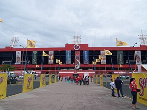
Estadio Luis "Pirata" Fuente
Football stadium in Veracruz, Mexico
Distance: Approx. 7618 meters
Latitude and longitude: 19.16422222,-96.12501667
The Estadio Luis "Pirata" Fuente is an association football stadium located at the seaside in Boca del Río, Veracruz, Mexico, with a capacity of 28,703. It is named in honour of Luis de la Fuente, a Mexican football star who played with C.D. Veracruz from 1943 to 1952. It was also the home of the Tiburones Rojos lit. 'Red Sharks' before the team's dissolution on December 18, 2019.

Veracruz Mexico Temple
Distance: Approx. 3887 meters
Latitude and longitude: 19.13441,-96.10626
The Veracruz Mexico Temple, located in Boca del Río in the Mexican state of Veracruz, is the 93rd operating temple of the Church of Jesus Christ of Latter-day Saints (LDS Church).

Jamapa River
River in Mexico
Distance: Approx. 166 meters
Latitude and longitude: 19.101278,-96.100806
The Río Jamapa is located in the Mexican state of Veracruz, forming in Citlaltépetl (also known as Pico de Orizaba) and pouring into the Gulf of Mexico in the municipality of Boca del Río (Mouth of the River).
Estadio Universitario Beto Ávila
Distance: Approx. 7631 meters
Latitude and longitude: 19.16509722,-96.12273611
Estadio Universitario Beto Ávila is a stadium in Veracruz, Mexico. It is primarily used for baseball and is home to El Águila de Veracruz of the Mexican League. It previously served as the home stadium for the Rojos del Águila de Veracruz from 1992 to 2017.

Isla de Sacrificios
Distance: Approx. 8401 meters
Latitude and longitude: 19.1751,-96.0921
Isla de Sacrificios ("Island of Sacrifices") is an island in the Gulf of Mexico, situated off the Gulf coastline near the port of Veracruz, in Mexico. The waters surrounding the island are part of the Sistema Arrecifal Veracruzano National Marine Park. It is currently closed to the public and is under the protection of the Secretariat of the Navy.
Parque Deportivo Veracruzano
Distance: Approx. 8258 meters
Latitude and longitude: 19.170111,-96.125664
Parque Deportivo Veracruzano was a multi-use stadium in Veracruz, Mexico. It was initially used as the stadium of Rojos del Águila de Veracruz and Tiburones Rojos de Veracruz matches. It was replaced by Estadio Universitario Beto Ávila in 2006 for Rojos del Águila de Veracruz and Estadio Luis de la Fuente in 1967 for the Tiburones Rojos de Veracruz .
Medellín Municipality, Veracruz
Place in Veracruz, Mexico
Distance: Approx. 7814 meters
Latitude and longitude: 19.06166667,-96.16222222
Medellín is a municipality in the Mexican state of Veracruz. The municipal seat is the town of Medellín.
Auditorio Benito Juárez
Arena in Veracruz, Mexico
Distance: Approx. 9491 meters
Latitude and longitude: 19.1783,-96.1357
Auditorio Benito Juarez is a 4,000-seat indoor arena located in Veracruz, Veracruz, Mexico. It was built in 1972 and renovated in 2004. It is the home of the Halcones Rojos de Veracruz basketball team, and one of two LNBP arenas named in honor of Benito Juárez.
La Joya (archaeological site)
Distance: Approx. 9683 meters
Latitude and longitude: 19.02833333,-96.15215556
La Joya is a Mesoamerican prehispanic archeological site, located in the municipality of Medellín in central Veracruz, Mexico, about 15 kilometers from the port of Veracruz, near the confluence of the Jamapa and Cotaxtla Rivers. The site, discovered and registered in 1935, is known as "La Joya de San Martín Garabato" and comprises several earthen structures from an alleged early Olmec origin. Remains of a continued human occupation throughout the classical period (200 BCE – 1000 CE) have been found), about 95% of the structures are destroyed by the common human carelessness and destruction.

ARM Guanajuato (C-07)
Former Mexican Navy gunboat
Distance: Approx. 448 meters
Latitude and longitude: 19.10045,-96.10423
ARM Guanajuato (C-07), also known as Cañonero Guanajuato, was a gunboat that served for the Mexican Navy until 2001. It has been located at the shore of the Jamapa River, in the municipality of Boca del Río, Veracruz, as a museum ship.

4th federal electoral district of Veracruz
Federal electoral district of Mexico
Distance: Approx. 0 meters
Latitude and longitude: 19.1,-96.1
The fourth federal electoral district of Veracruz (Distrito electoral federal 04 de Veracruz) is one of the 300 electoral districts into which Mexico is divided for elections to the federal Chamber of Deputies and one of 19 such districts in the state of Veracruz. It elects one deputy to the lower house of Congress for each three-year legislative session by means of the first-past-the-post system. Votes cast in the district also count towards the calculation of proportional representation ("plurinominal") deputies elected from the third region.
Weather in this IP's area
overcast clouds
22 Celsius
22 Celsius
22 Celsius
22 Celsius
1019 hPa
62 %
1019 hPa
1019 hPa
10000 meters
6.94 m/s
8.36 m/s
3 degree
94 %