Country:
Region:
City:
Latitude and Longitude:
Time Zone:
Postal Code:
IP information under different IP Channel
ip-api
Country
Region
City
ASN
Time Zone
ISP
Blacklist
Proxy
Latitude
Longitude
Postal
Route
Luminati
Country
ASN
Time Zone
America/Lima
ISP
INTERMAX S.A.C.
Latitude
Longitude
Postal
IPinfo
Country
Region
City
ASN
Time Zone
ISP
Blacklist
Proxy
Latitude
Longitude
Postal
Route
db-ip
Country
Region
City
ASN
Time Zone
ISP
Blacklist
Proxy
Latitude
Longitude
Postal
Route
ipdata
Country
Region
City
ASN
Time Zone
ISP
Blacklist
Proxy
Latitude
Longitude
Postal
Route
Popular places and events near this IP address

Tarata bombing
Terrorist attack in Lima, Peru
Distance: Approx. 100 meters
Latitude and longitude: -12.123345,-77.028193
The Tarata bombing, known also as the Miraflores bombing or Lima bombing, was a terrorist attack carried out in Tarata Street, located in Miraflores District of Lima, Peru, on 16 July 1992, by the leftist Shining Path terrorist group. The blast was one of the deadliest Shining Path bombings during the Internal conflict in Peru and was part of a larger bombing campaign in the city during the last stage of the terrorism era. The explosions happened next to the important Avenida Larco, in the business area of Miraflores, an upscale district of the city.

Surquillo
District in Lima, Peru
Distance: Approx. 1045 meters
Latitude and longitude: -12.11722222,-77.02055556
Surquillo is a district located in Lima, Peru. The district is bordered by the districts of San Isidro and San Borja on the north; by Miraflores on the south and west; and by Santiago de Surco on the east.

Larcomar
Shopping mall in Miraflores District, Lima
Distance: Approx. 992 meters
Latitude and longitude: -12.13111111,-77.03083333
Larcomar is a shopping center in the Miraflores district of Lima, Peru owned by Chilean company Parque Arauco S.A. It was opened on 27 November 1998. It is frequently visited by international tourists, as well as by locals from Miraflores and other parts of Lima. It is located on Avenida Jose Larco, and it is along the cliff next to the ocean (mar means 'sea' in Spanish) thus the name Larcomar.
Raúl Porras Barrenechea Institute
Distance: Approx. 505 meters
Latitude and longitude: -12.11833333,-77.02666667
The Raúl Porras Barrenechea Institute of the National University of San Marcos (IRPB-UNMSM) was founded in 1964 by the University of San Marcos in honor of the distinguished alum, Peruvian historian and diplomat Raúl Porras Barrenechea. The institute acts as a Center for Higher Studies and Peruvian Research, developing and promoting research mainly related to the areas of humanities, arts and social sciences. To this end, the institute offers researchers and the general public a library specialized in the mentioned fields.

Angamos metro station
Lima metro station
Distance: Approx. 1034 meters
Latitude and longitude: -12.11352778,-77.02602778
Angamos is a Lima and Callao Metro station on Line 1. The station is located between Cabitos and San Borja Sur. It was opened on 11 July 2011 as part of the extension of the line from Atocongo to Miguel Grau.

Miraflores Central Park
Park in Lima
Distance: Approx. 210 meters
Latitude and longitude: -12.1211,-77.0298
Miraflores Central Park (Spanish: Parque Central de Miraflores), also known as Miraflores Park (Spanish: Parque de Miraflores), is a public park located in Miraflores, Lima, Peru. It is divided into two parks: John F. Kennedy Park (Spanish: Parque John F. Kennedy) and 7 June Park (Spanish: Parque 7 de Junio). The former gives the entire park complex its popular name, Kennedy Park.

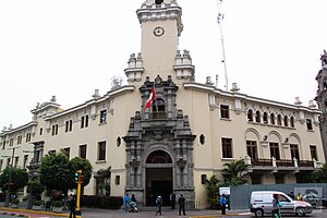
Palacio Municipal de Miraflores
Building in Lima, Peru
Distance: Approx. 117 meters
Latitude and longitude: -12.1218,-77.0293
The Municipal Palace of Miraflores (Spanish: Palacio Municipal de Miraflores) is the current headquarters of the municipal corporation of the Lima district of Miraflores in Peru. It is located at number 400 Larco Avenue, in front of Miraflores Central Park. It was declared a national monument in 1999.

Love Park, Lima
Park in Lima
Distance: Approx. 994 meters
Latitude and longitude: -12.1268,-77.0365
Alberto Andrade Carmona Park (Spanish: Parque Alberto Andrade Carmona), better known as Love Park (Spanish: Parque del Amor), is a public park in Lima, Peru.

Eduardo Villena Rey Bridge
Bridge in Lima, Peru
Distance: Approx. 961 meters
Latitude and longitude: -12.1275,-77.0357
Eduardo Villena Rey Bridge (Spanish: Puente Eduardo Villena Rey) is an arch bridge in Miraflores, Lima, Peru. It joins the Malecón de Miraflores and crosses the Bajada Balta.

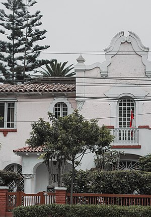
Quinta Leuro
Quinta in Lima, Peru
Distance: Approx. 781 meters
Latitude and longitude: -12.12877,-77.02529
The Quinta Leuro is an estate located in the district of Miraflores, Lima, Peru.

Parque Reducto No. 2
Park in Lima, Peru
Distance: Approx. 783 meters
Latitude and longitude: -12.12638889,-77.0225
The Parque Reducto No. 2 is a 20,000 m2 public park located at the intersections of Benavides and Luis Bedoya Reyes avenues, in Miraflores District, Lima, Peru. Located in a former redoubt built by the Peruvian Army during the War of the Pacific, it was declared a National Monument in 1944, and a Patriotic Sanctuary in 1965.

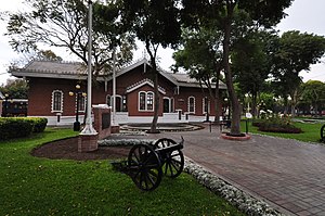
Andrés Avelino Cáceres Museum
Museum in Lima, Peru
Distance: Approx. 852 meters
Latitude and longitude: -12.12665,-77.02192
Andrés Avelino Cáceres Museum (Spanish: Museo de Sitio Andrés Avelino Cáceres) is a war museum located at a building formerly used as a train station at the Parque Reducto № 2 in Miraflores District, Lima, Peru. It is named after Marshal Andrés Avelino Cáceres, who participated at the park's defense during the War of the Pacific, then used as a redoubt.
Weather in this IP's area
scattered clouds
19 Celsius
19 Celsius
19 Celsius
19 Celsius
1013 hPa
79 %
1013 hPa
1002 hPa
10000 meters
3.08 m/s
3.24 m/s
177 degree
36 %
05:32:46
18:12:43
