45.181.137.117 - IP Lookup: Free IP Address Lookup, Postal Code Lookup, IP Location Lookup, IP ASN, Public IP
Country:
Region:
City:
Location:
Time Zone:
Postal Code:
ISP:
ASN:
language:
User-Agent:
Proxy IP:
Blacklist:
IP information under different IP Channel
ip-api
Country
Region
City
ASN
Time Zone
ISP
Blacklist
Proxy
Latitude
Longitude
Postal
Route
db-ip
Country
Region
City
ASN
Time Zone
ISP
Blacklist
Proxy
Latitude
Longitude
Postal
Route
IPinfo
Country
Region
City
ASN
Time Zone
ISP
Blacklist
Proxy
Latitude
Longitude
Postal
Route
IP2Location
45.181.137.117Country
Region
santa catarina
City
lagoa
Time Zone
America/Sao_Paulo
ISP
Language
User-Agent
Latitude
Longitude
Postal
ipdata
Country
Region
City
ASN
Time Zone
ISP
Blacklist
Proxy
Latitude
Longitude
Postal
Route
Popular places and events near this IP address

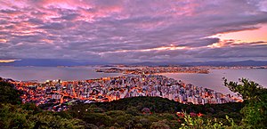
Florianópolis
Capital city of Santa Catarina, Brazil
Distance: Approx. 1970 meters
Latitude and longitude: -27.61222222,-48.48527778
Florianópolis (Portuguese pronunciation: [floɾiaˈnɔpolis]) is the capital and second largest city of the state of Santa Catarina, in the South region of Brazil. The city encompasses Santa Catarina Island and surrounding small islands, as well as part of the mainland. It has a population of 537,211, according to the 2022 Brazilian census, the second-most populous city in the state (after Joinville), and the 39th in Brazil.

Federal University of Santa Catarina
University in Florianópolis, Brazil
Distance: Approx. 5236 meters
Latitude and longitude: -27.60111111,-48.52
The Federal University of Santa Catarina (Portuguese: Universidade Federal de Santa Catarina, UFSC) is a public university in Florianópolis, the capital city of Santa Catarina in southern Brazil. Considered one of the leading universities in Brazil, UFSC is the 6th best university in Latin America in the ranking of Times Higher Education; the 23rd by QS World University Rankings, and was ranked as the 10th best institution of higher education in Latin America by the Webometrics Ranking of World Universities. In the annual ranking of the Brazilian newspaper Folha de São Paulo, it is the 6th best Brazilian university, with courses being among the ten best in the country.

Santa Catarina Island
Island in Santa Catarina, Brazil
Distance: Approx. 3291 meters
Latitude and longitude: -27.6,-48.5
Santa Catarina Island (Portuguese: Ilha de Santa Catarina) is an island in the Brazilian state of Santa Catarina, located off the southern coast. It is home to the state capital, Florianópolis.

Santa Catarina Art Museum
Museum in Florianopolis, Brazil
Distance: Approx. 6572 meters
Latitude and longitude: -27.5775,-48.5261
The Museu de Arte de Santa Catarina (MASC), was created in 1949 as Museu de Arte Moderna de Florianópolis (MAMF), and, since then, is the official institution for fine arts in Santa Catarina. Also known as MASC, it is an institution linked to the Fundação Catarinense de Cultura (FCC) and is currently housed in the building of the Centro Integrado de Cultura (CIC), at Avenida Gov. Irineu Bornhausen, No.
Barra da Lagoa
District in Santa Catarina, Brazil
Distance: Approx. 4725 meters
Latitude and longitude: -27.57805556,-48.43
Barra da Lagoa is a small fishing village in the city of Florianópolis, Santa Catarina, Brazil. The village is set on the mouth of a tidewater channel that flows in and out of the Island's sizable lagoon, the Lagoa da Conceição. The channel is at the end of a long beach made up of Praia Barra da Lagoa (English:Barra da Lagoa Beach) and Mozambique Beach which form a single 14 km stretch of beach.

Lagoa da Conceição
District in Santa Catarina, Brazil
Distance: Approx. 6340 meters
Latitude and longitude: -27.55,-48.45
Lagoa da Conceição (Portuguese: [laˈɡoɐ dɐ kõsejˈsɐ̃w]) is a district located next to a large lagoon of the same name near the center of Florianópolis, capital city of the state of Santa Catarina, located in the south of Brazil. Lagoa da Conceição combines beaches, dunes, hills, and the biggest lagoon on the island. The area has a small town center with a medical clinic, post office, pharmacies, supermarkets, boutique stores and specialty shops.
Tavares River
River in Brazil
Distance: Approx. 6826 meters
Latitude and longitude: -27.655,-48.507
The Tavares River or Rio Tavares is a river of Florianópolis, capital of Santa Catarina state in southeastern Brazil. Rio Tavares is also the name of a neighborhood in the city which is cut by the river.
Mole Beach
Beach located in the city of Florianópolis, Brazil
Distance: Approx. 3396 meters
Latitude and longitude: -27.6025,-48.43277778
Mole Beach (Portuguese: [ˈpɾajɐ ˈmɔli], Praia Mole) is located in the city of Florianópolis, Brazil. It is up to 120 metres wide and 960 metres long. It is an LGBT tourist spot in Florianópolis.

Santa Catarina State University
Distance: Approx. 5236 meters
Latitude and longitude: -27.6011,-48.52
Santa Catarina State University (Portuguese: Universidade do Estado de Santa Catarina, UDESC) is a public state university in Brazil. It was established in 1965. UDESC is located in Santa Catarina state in southern Brazil, primarily in Itacorubi, Florianópolis and Joinville, but it has multiple campuses in 10 cities.

Legislative Assembly of Santa Catarina
Legislative assembly of the state of Santa Catarina, Brazil
Distance: Approx. 7961 meters
Latitude and longitude: -27.60305556,-48.54777778
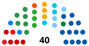
The Legislative Assembly of Santa Catarina (Portuguese: Assembleia Legislativa de Santa Catarina) is the unicameral legislature of Santa Catarina state in Brazil. It has 40 state deputies elected by proportional representation. The Assembly was created on August 12, 1834, the first legislature had 20 deputies, until 1881 when it was increased to 22.

Pirajubaé Marine Extractive Reserve
Distance: Approx. 7955 meters
Latitude and longitude: -27.65136,-48.52839
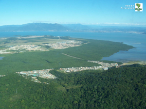
Pirajubaé Marine Extractive Reserve (Portuguese: Reserva Extrativista Marinha do Pirajubaé) is an extractive reserve in the state of Santa Catarina, Brazil, created in 1993. The purpose was to support sustainable harvesting of shellfish from a shoal in the south bay of the Santa Caterina Island. In recent years, due to various natural and human causes including dredging and over-fishing, the catch has declined steeply.

Rio Vermelho State Park
State park in Santa Catarina, Brazil
Distance: Approx. 7208 meters
Latitude and longitude: -27.546753,-48.434971
The Rio Vermelho State Park Portuguese: Parque Estadual do Rio Vermelho is a state park in the state of Santa Catarina, Brazil. It protects an area of restinga, dense rainforest and land modified by exotic plantations which is to be restored. The park provides a green space for visitors from the nearby state capital of Florianópolis.
Weather in this IP's area
clear sky
25 Celsius
26 Celsius
24 Celsius
25 Celsius
1015 hPa
96 %
1015 hPa
1012 hPa
10000 meters
2.06 m/s
250 degree

