45.181.122.253 - IP Lookup: Free IP Address Lookup, Postal Code Lookup, IP Location Lookup, IP ASN, Public IP
Country:
Region:
City:
Location:
Time Zone:
Postal Code:
ISP:
ASN:
language:
User-Agent:
Proxy IP:
Blacklist:
IP information under different IP Channel
ip-api
Country
Region
City
ASN
Time Zone
ISP
Blacklist
Proxy
Latitude
Longitude
Postal
Route
db-ip
Country
Region
City
ASN
Time Zone
ISP
Blacklist
Proxy
Latitude
Longitude
Postal
Route
IPinfo
Country
Region
City
ASN
Time Zone
ISP
Blacklist
Proxy
Latitude
Longitude
Postal
Route
IP2Location
45.181.122.253Country
Region
libertador general bernardo o'higgins
City
santa cruz
Time Zone
America/Santiago
ISP
Language
User-Agent
Latitude
Longitude
Postal
ipdata
Country
Region
City
ASN
Time Zone
ISP
Blacklist
Proxy
Latitude
Longitude
Postal
Route
Popular places and events near this IP address
Santa Cruz, Chile
City and commune in O'Higgins, Chile
Distance: Approx. 550 meters
Latitude and longitude: -34.63722222,-71.36305556
Santa Cruz is a Chilean city and commune, located in the Colchagua valley, in the O'Higgins Region, located on the southern shore of the Tinguiririca river, 110 miles from Santiago, Chile's capital city, and 27 miles from San Fernando.
Palmilla
City and Commune in O'Higgins, Chile
Distance: Approx. 3332 meters
Latitude and longitude: -34.60416667,-71.35833333
Palmilla is a Chilean city and commune in Colchagua Province, O'Higgins Region.

Paniahue
Distance: Approx. 1852 meters
Latitude and longitude: -34.61666667,-71.36666667
Paniahue (Mapudungun: proper place to take the glare) is a Chilean village located north of Santa Cruz, Colchagua Province, O'Higgins Region. In 1899, it had 1,055 inhabitants, its own post office and a free public school. It currently has 2,526 inhabitants.

Instituto Regional Federico Errázuriz
Primary and secondary school in Santa Cruz, Chile
Distance: Approx. 836 meters
Latitude and longitude: -34.63662222,-71.35851667
Instituto Regional Federico Errázuriz (Federico Errázuriz Regional Institute, in Spanish), also known as President Errázuriz Regional Institute or I.R.F.E., is a primary and secondary school in Santa Cruz, O'Higgins Region, Chile. It was founded in 1940 by Carlos Errázuriz Mena, member of the Chilean Christian Board. It is named after the former Presidents of Chile Federico Errázuriz Zañartu, and Federico Errázuriz Echaurren.
Evelyn's School
High school
Distance: Approx. 647 meters
Latitude and longitude: -34.63585,-71.37305
Evelyn's School is a Chilean high school located in Santa Cruz, Colchagua Province, Chile.
Colegio Santa Cruz de Unco
High school in Colchagua Province, Chile
Distance: Approx. 494 meters
Latitude and longitude: -34.63132,-71.36187
Colegio Santa Cruz de Unco (English: Santa Cruz de Unco School) is a Chilean high school located in Santa Cruz, Colchagua Province, Chile.
Instituto Politécnico Santa Cruz
High school
Distance: Approx. 137 meters
Latitude and longitude: -34.63218,-71.36609
Instituto Politécnico Santa Cruz (English: Santa Cruz Polytechnical Institute) is a Chilean high school located in Santa Cruz, Colchagua Province, Chile.
Barreales
Village in Libertador General Bernardo O'Higgins, Chile
Distance: Approx. 1082 meters
Latitude and longitude: -34.64083333,-71.37416667
Barreales is a Chilean village located in Santa Cruz, Colchagua Province, Libertador General Bernardo O'Higgins Region. It was also formerly known as (El) Barrial, (Los) Barriales, and Los Barreales.
Santa Cruz Airport (Chile)
Airport in Chile
Distance: Approx. 2515 meters
Latitude and longitude: -34.64805556,-71.3875
Santa Cruz Airport (Spanish: Aeropuerto de Santa Cruz, (ICAO: SCUZ)) is an airport 2 kilometres (1.2 mi) west of Santa Cruz, a city in the O'Higgins Region of Chile. The marked runway has a 170 metres (560 ft) overrun on the northwest end, terminated by a hangar. There is hilly terrain 3 kilometres (1.9 mi) west of the runway.
Isla del Guindo
Village in O'Higgins, Chile
Distance: Approx. 3577 meters
Latitude and longitude: -34.65,-71.33333333
Isla del Guindo is a village located in the Chilean commune of Santa Cruz, Colchagua province.
Chomedahue
Village in the O'Higgins Region, Chile
Distance: Approx. 3577 meters
Latitude and longitude: -34.65,-71.33333333
Chomedahue is a small town located in the Chilean commune of Santa Cruz, Colchagua province.

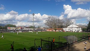
Estadio Municipal Joaquín Muñoz García
Distance: Approx. 805 meters
Latitude and longitude: -34.64,-71.37
Estadio Municipal Joaquín Muñoz García is a sports venue located in Santa Cruz, Chile, Province of Colchagua. It was inaugurated in 1920, being one of Chile's oldest stadiums. It bears the name in honor to Joaquín Muñoz García, one of Deportes Santa Cruz founders, who donated the land for the stadium's construction.
Weather in this IP's area
clear sky
37 Celsius
34 Celsius
37 Celsius
37 Celsius
1009 hPa
10 %
1009 hPa
971 hPa
10000 meters
5.22 m/s
3.27 m/s
267 degree
