Country:
 Brazil
Region:
City:
Latitude and Longitude:
Time Zone:
Postal Code:
IP information under different IP Channel
ip-api
Country
Region
City
ASN
Time Zone
ISP
Blacklist
Proxy
Latitude
Longitude
Postal
Route
IPinfo
Country
Region
City
ASN
Time Zone
ISP
Blacklist
Proxy
Latitude
Longitude
Postal
Route
MaxMind
Country
Region
City
ASN
Time Zone
ISP
Blacklist
Proxy
Latitude
Longitude
Postal
Route
Luminati
Country
BRRegion
es
City
vilavelha
ASN
Time Zone
America/Sao_Paulo
ISP
SUPERNETMAIS TELECOMUNICACOES LTDA
Latitude
Longitude
Postal
db-ip
Country
Region
City
ASN
Time Zone
ISP
Blacklist
Proxy
Latitude
Longitude
Postal
Route
ipdata
Country
Region
City
ASN
Time Zone
ISP
Blacklist
Proxy
Latitude
Longitude
Postal
Route
Popular places and events near this IP address

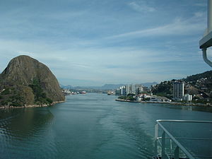
Vitória, Espírito Santo
Capital city of Espírito Santo, Brazil
Distance: Approx. 4442 meters
Latitude and longitude: -20.28888889,-40.30833333
Vitória (Portuguese pronunciation: [viˈtɔɾjɐ]; lit. 'Victory') is the capital of the state of Espírito Santo, Brazil. It is located on a small island within a bay where a number of rivers meet the sea. It was founded in 1551.

Vila Velha
Municipality in Southeast, Brazil
Distance: Approx. 1203 meters
Latitude and longitude: -20.33638889,-40.29361111
Vila Velha (Portuguese pronunciation: [ˈvilɐ ˈvɛʎɐ]; lit. 'Old Village') is a Brazilian municipality located in the state of Espírito Santo. It lies across from Vitória, the state capital. Its population was 467,722 (2022) and its area is 210.23 km2.

Penha Convent
Distance: Approx. 642 meters
Latitude and longitude: -20.3293,-40.2871
Penha Convent (Portuguese: Convento da Penha) is a convent in Vila Velha, Brazil, on the top of a high mountain overlooking the cities of Vitória and Vila Velha. Founded in approximately 1558 by Pedro Palácios, today it is home to Espírito Santo's Patron Saint, Our Mother of Penha. Many believers make pilgrimages to this site which is surrounded by a green haven of forest.

Garoto
Brazilian chocolate manufacturer
Distance: Approx. 2179 meters
Latitude and longitude: -20.33777778,-40.30833333
Chocolates Garoto S.A. is a Brazilian chocolate manufacturer. Its headquarters are located in Vila Velha, Espírito Santo. The company was founded in 1929 by German immigrant Heinrich Meyerfreund and acquired by Nestlé in 2002.

Third Bridge
Bridge
Distance: Approx. 985 meters
Latitude and longitude: -20.3201,-40.2846
The Deputy Darcy Castelo de Mendonça Bridge, colloquially known as the Third Bridge (Portuguese: Terceira Ponte), is the second tallest bridge in Brazil, connecting the cities of Vila Velha and Vitória in the state of Espírito Santo. Spanning the mouth of Vitória's bay, which has many other features, including the Penha Convent, Moreno's hill, freight ships, coastline, islands and modern buildings, the bridge has become one of Espírito Santo's main landmarks.

Santa Maria da Vitória River
River in Brazil
Distance: Approx. 1346 meters
Latitude and longitude: -20.31666667,-40.28333333
The Santa Maria da Vitória River is a river of Espírito Santo state in eastern Brazil.

Legislative Assembly of Espírito Santo
Distance: Approx. 1549 meters
Latitude and longitude: -20.3119,-40.29
The Legislative Assembly of Espírito Santo (Portuguese: Assembleia Legislativa do Espírito Santo) is the unicameral legislature of the state of Espírito Santo in Brazil. It has 30 state deputies elected by proportional representation. It is located in the city of Vitória.
Morro do Penedo Natural Monument
Distance: Approx. 3455 meters
Latitude and longitude: -20.323804,-40.324934
The Morro do Penedo Natural Monument (Portuguese: Monumento Natural Municipal Morro do Penedo) is a municipal natural monument in the state of Espírito Santo, Brazil. It contains a small sugarloaf hill on the shore of the bay to the south of Vitória, the state capital.
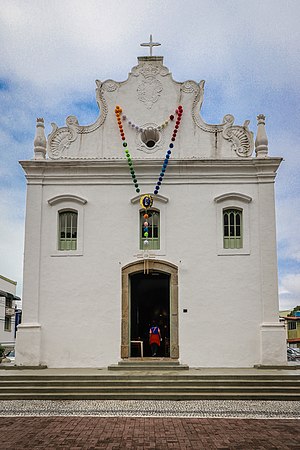
Church of Our Lady of the Rosary (Vila Velha)
Catholic temple in Vila Velha, Espírito Santo, Brazil
Distance: Approx. 556 meters
Latitude and longitude: -20.33068889,-40.29211111
The Church of Our Lady of the Rosary (Portuguese: Igreja de Nossa Senhora do Rosário) is a Catholic temple located in the Prainha Historic Site, in the municipality of Vila Velha, in the state of Espírito Santo. It is considered one of the oldest churches in Brazil and a landmark of the colonization of the territory of Espírito Santo.

Fort of São Francisco Xavier de Piratininga
Military structure in Espirito Santo, Brazil
Distance: Approx. 594 meters
Latitude and longitude: -20.32361111,-40.28666667
The Fort of São Francisco Xavier de Piratininga, also known as the Fort of São Francisco Xavier da Barra or simply as the Fort of Piratininga, is located in the Inhoã Cove, in the city of Vila Velha, in the Brazilian state of Espírito Santo. Strategically erected at the base of Penha Hill, its mission was to defend the southern bar of Vitória Bay, on the coast of the former Captaincy of Espírito Santo.

Solar Monjardim Museum
Brazilian historical public museum in Vitória, Espírito Santo
Distance: Approx. 3836 meters
Latitude and longitude: -20.3058,-40.3219
The Solar Monjardim Museum (MSM) is a Brazilian historical public museum located in the Solar Monjardim, in Santa Cecília, neighborhood of Vitória, Espírito Santo. The museum is currently one of the federal institutions administered by the Brazilian Institute of Museums (Ibram).
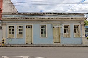
Memory House Museum
Museum in Vila Velha, Brazil
Distance: Approx. 417 meters
Latitude and longitude: -20.329431,-40.292211
The Memory House Museum (Portuguese: Museu Casa da Memória) is a Brazilian museum in Vila Velha, created in 1997. It is located in a house built in 1893, which was restored by the DEC/ES through the efforts of a group of volunteers and Vila Velha residents. The project began in 1993 and was inaugurated as the Memory House Museum in 1994.
Weather in this IP's area
few clouds
23 Celsius
24 Celsius
23 Celsius
24 Celsius
1012 hPa
82 %
1012 hPa
1012 hPa
10000 meters
5.14 m/s
360 degree
20 %
05:20:13
17:39:42