Country:
 Brazil
Region:
City:
Latitude and Longitude:
Time Zone:
Postal Code:
IP information under different IP Channel
ip-api
Country
Region
City
ASN
Time Zone
ISP
Blacklist
Proxy
Latitude
Longitude
Postal
Route
IPinfo
Country
Region
City
ASN
Time Zone
ISP
Blacklist
Proxy
Latitude
Longitude
Postal
Route
MaxMind
Country
Region
City
ASN
Time Zone
ISP
Blacklist
Proxy
Latitude
Longitude
Postal
Route
Luminati
Country
BRRegion
sp
City
maua
ASN
Time Zone
America/Sao_Paulo
ISP
BATISTA E SANTOS LTDA
Latitude
Longitude
Postal
db-ip
Country
Region
City
ASN
Time Zone
ISP
Blacklist
Proxy
Latitude
Longitude
Postal
Route
ipdata
Country
Region
City
ASN
Time Zone
ISP
Blacklist
Proxy
Latitude
Longitude
Postal
Route
Popular places and events near this IP address
Santo André, São Paulo
Municipality in Southeast, Brazil
Distance: Approx. 6809 meters
Latitude and longitude: -23.65722222,-46.53333333
Santo André (Portuguese pronunciation: [sɐ̃twɐ̃ˈdɾɛ], Saint Andrew) is a Brazilian municipality located in the Metropolitan Region of São Paulo. It is part of a group of municipalities known as the ABC Region. According to the most recent census in 2022, the population is estimated at 748,919 in an area of 175.8 km².

Mauá
Place in Southeast, Brazil
Distance: Approx. 690 meters
Latitude and longitude: -23.66777778,-46.46083333
Mauá (Portuguese pronunciation: [maˈwa]) is a municipality in the state of São Paulo, in Brazil. Is part of the metropolitan region of São Paulo. The population as of 2020 is 477,552 inhabitants (11th largest city in population number of the state), the density is 7,500 per square kilometre (19,000/sq mi) and the area is 62.6 square kilometres (24.2 sq mi).

Capuava
District in Brazil
Distance: Approx. 3936 meters
Latitude and longitude: -23.64444444,-46.49638889
Capuava is a district of the municipality of Santo André, in the Brazilian state of São Paulo. Created in 1985, the district of Capuava was formed from a part of the Utinga subdistrict, and is situated in one of the most industrialized regions of the city. Geopolitical researchers say that one of the reasons for the creation of this new district was mainly to prevent the subdistrict of Utinga from separating from Santo André, since the industrial power of Utinga was set in Capuava zone.

Estádio Bruno José Daniel
Distance: Approx. 4241 meters
Latitude and longitude: -23.66944444,-46.50916667
The Estádio Bruno José Daniel, sometimes called Brunão or Estádio Municipal Bruno José Daniel, is a football stadium in Santo André, São Paulo state. The stadium, which opened on December 14, 1969, has a maximum capacity of 18,000 people. It is owned by the City Hall of Santo André, and is the home of Santo André.

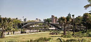
Federal University of ABC
Public federal university in São Paulo, Brazil
Distance: Approx. 6670 meters
Latitude and longitude: -23.645,-46.528
Federal University of ABC (Portuguese: Universidade Federal do ABC, UFABC) is a Brazilian federal public institution of higher learning based in Santo André and São Bernardo do Campo, municipalities belonging to the ABC region, both in the state of São Paulo. UFABC is the only federal university in Brazil with 100% of its professors holding PhDs and, for the second consecutive year in 2011, emerged as the only university in Brazil with impact factor in scientific publications above the world average according to SCImago Institutions Rankings. The institution was evaluated by the General Course Index (IGC) of the Ministry of Education (MEC) as the best university in the State of São Paulo, being rated as the 1st in the ranking of undergraduate courses among all universities in Brazil.

Subprefecture of São Mateus
Subprefecture in Southeast, Brazil
Distance: Approx. 6886 meters
Latitude and longitude: -23.60638889,-46.47361111
The Subprefecture of São Mateus is one of 32 subprefectures of the city of São Paulo, Brazil. It comprises three districts: São Mateus, São Rafael, and Iguatemi.

Sabina Escola Parque do Conhecimento
Science museum
Distance: Approx. 6608 meters
Latitude and longitude: -23.67903,-46.53129
The Sabina School Park of Knowledge (Portuguese: Sabina Escola Parque do Conhecimento) is a science museum in Santo André, São Paulo, Brazil. Other planetaria in Greater São Paulo include Professor Aristóteles Orsini Planetarium and Carmo Planetarium.
Estádio Pedro Benedetti
Distance: Approx. 317 meters
Latitude and longitude: -23.66888889,-46.47055556
The Estádio Municipal Pedro Benedetti is a football stadium in Mauá, São Paulo, Brazil. It is the home ground of Grêmio Mauaense and Mauá Futebol. The stadium has a maximum capacity of 11,986, although only up to 8,567 fans are allowed in by the Military Firefighters Corps.
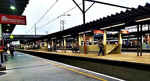
Pref. Celso Daniel-Santo André (CPTM)
Railway station in São Paulo, Brazil
Distance: Approx. 6425 meters
Latitude and longitude: -23.652244,-46.528221
Prefeito Celso Daniel-Santo André, or informally known only as Santo André, is a train station on CPTM Line 10 (Turquoise), in the city of Santo André.

Capuava (CPTM)
Railway station in São Paulo, Brazil
Distance: Approx. 2532 meters
Latitude and longitude: -23.658357,-46.490096
Capuava is a train station on CPTM Line 10-Turquoise, located in the city of Mauá. It was opened in 1920 as a telegraph post and, in 1960, its original building was replaced by the one who is up until today.

Mauá (CPTM)
Railway station in São Paulo, Brazil
Distance: Approx. 610 meters
Latitude and longitude: -23.668095,-46.461616
Mauá is a train station on CPTM, commuter rail in Sao Paulo, Brazil, Line 10-Turquoise, located in the city of Mauá.
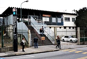
Guapituba (CPTM)
Railway station in São Paulo, Brazil
Distance: Approx. 3320 meters
Latitude and longitude: -23.692172,-46.448532
Guapituba is a train station on CPTM Line 10-Turquoise, located in the city of Mauá.
Weather in this IP's area
clear sky
20 Celsius
20 Celsius
20 Celsius
22 Celsius
1015 hPa
78 %
1015 hPa
929 hPa
10000 meters
4.63 m/s
120 degree
05:44:41
18:05:16