Country:
Region:
City:
Latitude and Longitude:
Time Zone:
Postal Code:
IP information under different IP Channel
ip-api
Country
Region
City
ASN
Time Zone
ISP
Blacklist
Proxy
Latitude
Longitude
Postal
Route
Luminati
Country
Region
se
City
saocristovao
ASN
Time Zone
America/Maceio
ISP
Lehi V. de Aguiar Solucoes
Latitude
Longitude
Postal
IPinfo
Country
Region
City
ASN
Time Zone
ISP
Blacklist
Proxy
Latitude
Longitude
Postal
Route
db-ip
Country
Region
City
ASN
Time Zone
ISP
Blacklist
Proxy
Latitude
Longitude
Postal
Route
ipdata
Country
Region
City
ASN
Time Zone
ISP
Blacklist
Proxy
Latitude
Longitude
Postal
Route
Popular places and events near this IP address

Itaporanga d'Ajuda
Municipality in Northeast Region, Brazil
Distance: Approx. 9370 meters
Latitude and longitude: -10.99777778,-37.31083333
Itaporanga d'Ajuda is a Brazilian municipality in the Northeastern state of Sergipe. It covers 757 square kilometres (292 sq mi), has a population of 34,709 (2020) and a population density of 46 residents per km2 (120/sq mi). It is home to the Tejupeba House and the Chapel of the Colégio Sugar Plantation, a plantation house and chapel cited as the first Jesuits settlement in Portuguese Brazil.

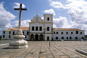
São Francisco Square
UNESCO World Heritage Site in Sergipe, Brazil
Distance: Approx. 8636 meters
Latitude and longitude: -11.01611111,-37.21
São Francisco Square (Portuguese: Praça São Francisco) is a historic plaza in São Cristóvão, Sergipe, Brazil. The square, or praça, is an open space surrounded by Portuguese colonial-period buildings such as the Church and Convent of Santa Cruz (São Francisco Church), the Misericórdia Hospital and Church, the Provincial Palace and buildings from later periods. The complex is a well-preserved example of both the Spanish colonial and the Portuguese Franciscan architecture of north-eastern Brazil.
Weather in this IP's area
broken clouds
26 Celsius
26 Celsius
26 Celsius
26 Celsius
1012 hPa
78 %
1012 hPa
1007 hPa
10000 meters
4.12 m/s
70 degree
75 %
04:55:17
17:34:27