Country:
Region:
City:
Latitude and Longitude:
Time Zone:
Postal Code:
IP information under different IP Channel
ip-api
Country
Region
City
ASN
Time Zone
ISP
Blacklist
Proxy
Latitude
Longitude
Postal
Route
Luminati
Country
Region
cmx
City
mexicocity
ASN
Time Zone
America/Mexico_City
ISP
Bicentel SA de CV
Latitude
Longitude
Postal
IPinfo
Country
Region
City
ASN
Time Zone
ISP
Blacklist
Proxy
Latitude
Longitude
Postal
Route
db-ip
Country
Region
City
ASN
Time Zone
ISP
Blacklist
Proxy
Latitude
Longitude
Postal
Route
ipdata
Country
Region
City
ASN
Time Zone
ISP
Blacklist
Proxy
Latitude
Longitude
Postal
Route
Popular places and events near this IP address

San Pedro Garza García
Place in Nuevo León, Mexico
Distance: Approx. 364 meters
Latitude and longitude: 25.66666667,-100.3
San Pedro Garza García (also known as San Pedro) is a city-municipality in the Mexican state of Nuevo León and part of the Monterrey Metropolitan area. It is a contemporary commercial suburb of the larger metropolitan city of Monterrey between Puente de la Unidad and the Alfa Planetarium, including areas surrounding Calzada del Valle/Calzada San Pedro. In 2018 it was evaluated as having the best quality of life in Mexico.

Faro del Comercio
Monument in Mexico
Distance: Approx. 1053 meters
Latitude and longitude: 25.66619444,-100.31002778
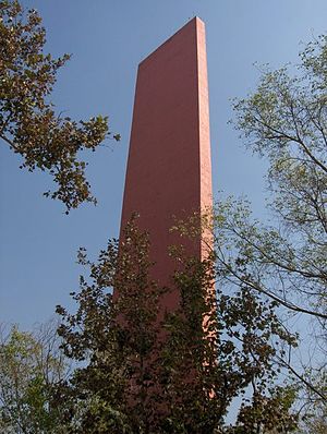
Faro del Comercio is a monument designed by the accomplished Mexican architect Luis Barragán and constructed in 1984 by architect Raúl Ferrera. It is a recognizable sight in Monterrey among many other modern manmade landmarks, such as Neptune's Fountain (Fuente de la Vida), the Monterrey City Hall, the Papal Bridge (El Puente del Papa), and the Bridge of Unity (Puente de la Unidad) in San Pedro, connecting that municipality to Monterrey. These sites are intended on one hand to complement the city's few remaining traditional landmarks, such as, the Bishopric Palace (Palacio del Obispado) and Museum, the City's Cathedral (Catedral Metropolitana de Nuestra Señora de Monterrey), the Central Post Office (old Monterrey City Hall), and the State of Nuevo León Government building, on the north end of the Macroplaza.
Roman Catholic Archdiocese of Monterrey
Latin Catholic jurisdiction in Mexico
Distance: Approx. 1033 meters
Latitude and longitude: 25.6656,-100.31
The Archdiocese of Monterrey (Latin: Archidioecesis Monterreyensis) is a Latin Church ecclesiastical territory or archdiocese of the Catholic Church located in Monterrey, Nuevo León, Mexico. The Archdiocese of Monterrey is a metropolitan see; its suffragan dioceses are the Ciudad Victoria, Linares, Matamoros, Nuevo Laredo, Piedras Negras, Saltillo and Tampico.
Macroplaza
Town square or plaza in Monterrey, Mexico
Distance: Approx. 1135 meters
Latitude and longitude: 25.66861111,-100.30972222
The Macroplaza or La Gran Plaza is a town square or plaza located in the heart of the city of Monterrey, Mexico. The Macroplaza is the fifth-largest plaza in the world and the largest Plaza in Mexico. It has an extension of 400,000 square metres consisting of various monuments, smaller plazas and gardens.

General I. Zaragoza metro station
Monterrey metro station
Distance: Approx. 1141 meters
Latitude and longitude: 25.66777778,-100.31027778
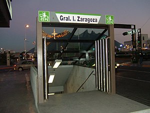
General I. Zaragoza (Spanish: Estación General I. Zaragoza or Terminal Zaragoza) is a station on Lines 2 and 3 of the Monterrey Metro. It is located in Monterrey, on the heart of the Macroplaza. The station was opened on 30 November 1994 as the eastern terminus of the inaugural section of Line 2, between General Anaya and Zaragoza.

XHAW-TDT
Multimedios Televisión station in Monterrey
Distance: Approx. 691 meters
Latitude and longitude: 25.65721,-100.29953
XHAW-TDT, virtual channel 6 (UHF digital channel 25), is the flagship station of the Multimedios television network, licensed to Monterrey, Nuevo León and Saltillo, Coahuila, Mexico. The station is owned by Grupo Firmas Globales.

Barrio Antiguo
Distance: Approx. 806 meters
Latitude and longitude: 25.66684444,-100.30706944
Popularly known as the Barrio Antiguo (Spanish old quarter) comprise what is preserved from the historical quarter of the city of Monterrey, Nuevo León, Mexico. Currently located next to the Government Palace and the Macroplaza, it originally covered a larger space from the Santa Catarina River to 5 de Mayo Street, south to north, and from Mina Street to Roble Street (nowadays Avenida Benito Juárez), east to west. Most of the buildings now preserved are from the Spanish Colonial period and from the last years of the 19th century.

Mexican Professional Baseball Hall of Fame
Baseball hall of fame
Distance: Approx. 1125 meters
Latitude and longitude: 25.67277778,-100.29583333
The Salón de la Fama del Beisbol Mexicano (in English, Mexican Professional Baseball Hall of Fame), commonly called the Salón de la Fama (Hall of Fame) is a baseball hall of fame and museum located in Monterrey, Nuevo León, inaugurated on 10 March 1973. It is dedicated to recognizing people who have contributed greatly to baseball in México. It had its first five inductees in 1939.
Santa Lucía riverwalk
Distance: Approx. 1039 meters
Latitude and longitude: 25.67257778,-100.29811667
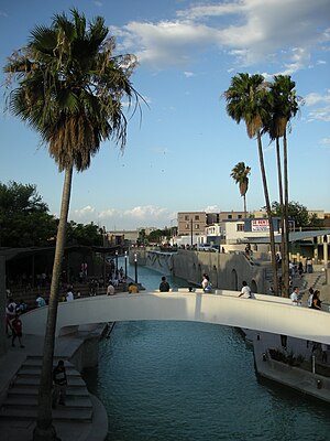
The Santa Lucia riverwalk (Spanish: Paseo Santa Lucía) is an artificial river located in the Mexican city of Monterrey, Nuevo León.

Urban water management in Monterrey, Mexico
City in Nuevo León, Mexico
Distance: Approx. 364 meters
Latitude and longitude: 25.66666667,-100.3
Early in the 20th century, Monterrey, Mexico began a successful economic metamorphosis and growth pattern that remains an exception in Mexico. This all began with increased investments in irrigation that fueled a boom in agriculture and ranching for this northern Mexican city. The economic growth has fueled income disparity for the 3.86 million residents who live in the Monterrey Metro area (MMA).
Timeline of Monterrey, Mexico
Distance: Approx. 364 meters
Latitude and longitude: 25.666667,-100.3
The following is a timeline of the history of the city of Monterrey, Nuevo León, Mexico.
Monterrey Cathedral
Church in Monterrey, Mexico
Distance: Approx. 1013 meters
Latitude and longitude: 25.6656,-100.3098
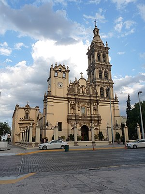
The Metropolitan Cathedral of Our Lady of Monterrey (Spanish: Catedral Metropolitana de Nuestra Señora de Monterrey) also Monterrey Cathedral is the main Catholic church and home of the Archdiocese of Monterrey. It is located in the capital of the state of Nuevo León in Mexico. The building has a central nave in the shape of a Latin cross flanked by niches chapels.
Weather in this IP's area
clear sky
24 Celsius
24 Celsius
24 Celsius
25 Celsius
1016 hPa
52 %
1016 hPa
956 hPa
10000 meters
3.24 m/s
3.76 m/s
111 degree
10 %
06:58:43
17:52:58


