45.163.186.55 - IP Lookup: Free IP Address Lookup, Postal Code Lookup, IP Location Lookup, IP ASN, Public IP
Country:
Region:
City:
Location:
Time Zone:
Postal Code:
ISP:
ASN:
language:
User-Agent:
Proxy IP:
Blacklist:
IP information under different IP Channel
ip-api
Country
Region
City
ASN
Time Zone
ISP
Blacklist
Proxy
Latitude
Longitude
Postal
Route
db-ip
Country
Region
City
ASN
Time Zone
ISP
Blacklist
Proxy
Latitude
Longitude
Postal
Route
IPinfo
Country
Region
City
ASN
Time Zone
ISP
Blacklist
Proxy
Latitude
Longitude
Postal
Route
IP2Location
45.163.186.55Country
Region
bahia
City
cachoeira
Time Zone
America/Bahia
ISP
Language
User-Agent
Latitude
Longitude
Postal
ipdata
Country
Region
City
ASN
Time Zone
ISP
Blacklist
Proxy
Latitude
Longitude
Postal
Route
Popular places and events near this IP address

Cachoeira
Municipality in Bahia, Brazil
Distance: Approx. 3769 meters
Latitude and longitude: -12.58444444,-38.95583333
Cachoeira (Portuguese, meaning waterfall) is an inland municipality of Bahia, Brazil, on the Paraguaçu River. The town exports sugar, cotton, and tobacco and is a thriving commercial and industrial centre. The municipality contains 56% of the 10,074 hectares (24,890 acres) Baía do Iguape Marine Extractive Reserve, created in 2000.
Muritiba
Municipality in Nordeste, Brazil
Distance: Approx. 3808 meters
Latitude and longitude: -12.6258,-38.99
Muritiba is a municipality in the state of Bahia in the North-East region of Brazil.
Governador Mangabeira
Municipality in Nordeste, Brazil
Distance: Approx. 9623 meters
Latitude and longitude: -12.60194444,-39.04277778
Governador Mangabeira is a municipality in the state of Bahia in the North-East region of Brazil.

São Félix, Bahia
Municipality in Northeast, Brazil
Distance: Approx. 1946 meters
Latitude and longitude: -12.60691944,-38.96939444
São Félix, Bahia is a municipality in Bahia, Brazil. The municipality has a population of 14,762 with a population density of 142 inhabitants per square kilometer. It is located 110 km (68 mi) from the state capital of Bahia, Salvador.

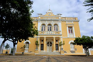
Town Hall of São Félix
Town hall in Bahia, Brazil
Distance: Approx. 1991 meters
Latitude and longitude: -12.606502,-38.969577
The Town Hall of São Félix (Portuguese: Paço Municipal de São Félix) is an 18th-century municipal building in São Félix, Bahia, Brazil. São Félix was a district of Cachoeira, a municipality across the Paraguaçu River, during the Portuguese colonial period of Brazil. It experienced a boom in tobacco production in the late 19th century and became the largest producers of cigars in Brazil.
Weather in this IP's area
overcast clouds
27 Celsius
30 Celsius
27 Celsius
27 Celsius
1009 hPa
79 %
1009 hPa
991 hPa
10000 meters
0.81 m/s
1.92 m/s
304 degree
99 %