45.163.123.230 - IP Lookup: Free IP Address Lookup, Postal Code Lookup, IP Location Lookup, IP ASN, Public IP
Country:
 Mexico
Region:
City:
Location:
Time Zone:
Postal Code:
ISP:
ASN:
language:
User-Agent:
Proxy IP:
Blacklist:
IP information under different IP Channel
ip-api
Country
Region
City
ASN
Time Zone
ISP
Blacklist
Proxy
Latitude
Longitude
Postal
Route
db-ip
Country
Region
City
ASN
Time Zone
ISP
Blacklist
Proxy
Latitude
Longitude
Postal
Route
IPinfo
Country
Region
City
ASN
Time Zone
ISP
Blacklist
Proxy
Latitude
Longitude
Postal
Route
IP2Location
45.163.123.230Country
mxRegion
michoacan de ocampo
City
morelia
Time Zone
America/Mexico_City
ISP
Language
User-Agent
Latitude
Longitude
Postal
ipdata
Country
Region
City
ASN
Time Zone
ISP
Blacklist
Proxy
Latitude
Longitude
Postal
Route
Popular places and events near this IP address

Morelia Cathedral
Church in Morelia, Mexico
Distance: Approx. 830 meters
Latitude and longitude: 19.7028,-101.192
The Metropolitan Cathedral of Morelia (Spanish: Catedral Metropolitana de Morelia (San Salvador)) is a religious site that is the seat of the Archdiocese of Morelia of the Catholic church in Mexico. It is located as its name itself says in the city of Morelia, capital of the state of Michoacán, Mexico. The cathedral is located in the first square of the city, forming the trace of the Historic Center of Morelia.

Roman Catholic Archdiocese of Morelia
Latin Catholic jurisdiction in Mexico
Distance: Approx. 819 meters
Latitude and longitude: 19.7024,-101.192
The Archdiocese of Morelia (Latin: Archidioecesis Moreliensis) is a Latin Church ecclesiastical territory or archdiocese of the Catholic Church in western central Mexico. It was erected on 11 August 1536 as the Diocese of Michoacán. The cathedra is found in the Cathedral of the Transfiguration in the episcopal see of Morelia, capital of Michoacán state.

Morelia Institute of Technology
Public university in Michoacán, Mexico
Distance: Approx. 2543 meters
Latitude and longitude: 19.7235,-101.1859
The Morelia Institute of Technology (in Spanish: Instituto Tecnológico de Morelia), also known as Morelia Tech (Tec de Morelia), is a public university in Morelia, Michoacán, México founded in 1964.

Universidad Michoacana de San Nicolás de Hidalgo
Public university in Michoacán, Mexico
Distance: Approx. 2575 meters
Latitude and longitude: 19.6914,-101.2069
Michoacana University of San Nicolás de Hidalgo (UMSNH) is a public university in Morelia, Michoacán, Mexico, and the oldest institution of higher education in the Americas. The University grants law, economics, computer science, medicine, architecture, and dentistry degrees, plus several other additional fields of study, mainly in Humanities, Science, Engineering and Arts.

Morelia grenade attacks
Distance: Approx. 983 meters
Latitude and longitude: 19.7024,-101.1936
The Morelia grenade attacks took place on 15 September 2008 on the occasion of the Mexican Independence Day anniversary when thousands of people were gathered in the Plaza Melchor Ocampo, the main square of the Mexican city of Morelia, Michoacán. Shortly after the Grito (a harangue) in that city, led by Governor Leonel Godoy, two grenades were thrown into the crowds, killing at least eight people and injuring more than 100.

Estadio Venustiano Carranza
Sporting venue in Mexico
Distance: Approx. 1712 meters
Latitude and longitude: 19.700294,-101.168075
Estadio Olimpico Venustiano Carranza is a multi-use stadium in Morelia, Mexico, used mostly for football matches and also for athletics. It was initially used as the stadium of Monarcas Morelia matches. It was replaced by Estadio Morelos when Monarcas Morelia moved there in 1989.
Instituto Maristas Valladolid
Marist brothers, catholic school in Diego Jose Abad , Morelia, Michoacán, Mexico
Distance: Approx. 130 meters
Latitude and longitude: 19.69967778,-101.18499444
Instituto Maristas Valladolid was founded by the Marist Brothers in 1941. It includes divisions from preschool through the university level. It is located in Morelia (formerly Valladolid), Michoacán, Mexico.

Antiguo Real Hospital de San Juan de Dios
Part of a World Heritage site in Mexico
Distance: Approx. 759 meters
Latitude and longitude: 19.7025,-101.19138889
El Antiguo Real Hospital de San Juan de Dios (English: The Old Royal Hospital of San Juan de Dios) is a historical building built in the 17th century in Morelia, Michoacán, Mexico. Its design combines Baroque and neoclassical architectural styles. With a long history, first as a Bishop's House, then as a hospital, and later as a hotel, it is an important example of the architecture of that period and an important tourist attraction for the city of Morelia.
Antimonumenta (Morelia)
Anti-monument in Morelia, Michoacán
Distance: Approx. 311 meters
Latitude and longitude: 19.70288889,-101.18255556
An antimonumenta was installed next to the Fuente de las Tarascas, along Francisco I. Madero Avenue in Morelia, Michoacán, on 8 March 2021, the date commemorating International Women's Day, during the annual march of women protesting against gender violence. The sculpture, symbolically named Antimonumenta, was inspired by other similar anti-monuments like the one in Mexico City. The erection of an antimonumenta symbolizes the demand for justice for women who suffer from violence in the country.

Fuente de las Tarascas
Fountain and sculpture in Morelia, Michoacán, Mexico
Distance: Approx. 318 meters
Latitude and longitude: 19.70286111,-101.18241667
The Fuente de las Tarascas (Las Tarascas Fountain), also known as the Fuente de la Fertilidad (Fertility Fountain), is a fountain, sculpture and landmark installed in Morelia, Michoacán, Mexico. The original work was created by Antonio Silva Díaz and Benigno Lara and was installed in 1931 in the intersection of Francisco I. Madero Avenue and Acueducto Avenue, in the historic center of the city. The fountain had three colorful concrete statues that depicted three bare-chested, kneeling women holding a basket of fruits.
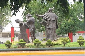
Monumento a los Constructores
Partly-destroyed sculpture in Morelia, Michoacán
Distance: Approx. 1723 meters
Latitude and longitude: 19.69677778,-101.1685
The Monumento a los Constructores (lit. transl. Builders Monument), also known as the Monumento a los Constructores de la Ciudad (lit. transl. Builders of the City Monument), is a partly-destroyed outdoor bronze monument installed along Acueducto Avenue, in the historic center of Morelia, Michoacán, Mexico.

10th federal electoral district of Michoacán
Federal electoral district of Mexico
Distance: Approx. 136 meters
Latitude and longitude: 19.7,-101.18333333
The 10th federal electoral district of Michoacán (Distrito electoral federal 10 de Michoacán) is one of the 300 electoral districts into which Mexico is divided for elections to the federal Chamber of Deputies and one of eleven such districts in the state of Michoacán. It elects one deputy to the lower house of Congress for each three-year legislative session by means of the first-past-the-post system. Votes cast in the district also count towards the calculation of proportional representation ("plurinominal") deputies elected from the fifth region.
Weather in this IP's area
broken clouds
24 Celsius
23 Celsius
24 Celsius
24 Celsius
1014 hPa
48 %
1014 hPa
793 hPa
10000 meters
2.23 m/s
1.96 m/s
165 degree
67 %