45.161.222.209 - IP Lookup: Free IP Address Lookup, Postal Code Lookup, IP Location Lookup, IP ASN, Public IP
Country:
Region:
City:
Location:
Time Zone:
Postal Code:
IP information under different IP Channel
ip-api
Country
Region
City
ASN
Time Zone
ISP
Blacklist
Proxy
Latitude
Longitude
Postal
Route
Luminati
Country
Region
al
City
saojosedatapera
ASN
Time Zone
America/Maceio
ISP
CLICK NET CONNECT
Latitude
Longitude
Postal
IPinfo
Country
Region
City
ASN
Time Zone
ISP
Blacklist
Proxy
Latitude
Longitude
Postal
Route
IP2Location
45.161.222.209Country
Region
alagoas
City
sao jose da tapera
Time Zone
America/Maceio
ISP
Language
User-Agent
Latitude
Longitude
Postal
db-ip
Country
Region
City
ASN
Time Zone
ISP
Blacklist
Proxy
Latitude
Longitude
Postal
Route
ipdata
Country
Region
City
ASN
Time Zone
ISP
Blacklist
Proxy
Latitude
Longitude
Postal
Route
Popular places and events near this IP address

Carneiros
Municipality in Alagoas, Brazil
Distance: Approx. 8419 meters
Latitude and longitude: -9.48277778,-37.37694444
Carneiros is a municipality located in the western of the Brazilian state of Alagoas. Its population is 9.159 (2020) and its area is 113 km².

Olho d'Água das Flores
Municipality in Alagoas, Brazil
Distance: Approx. 9895 meters
Latitude and longitude: -9.53583333,-37.29388889
Olho d'Água das Flores is a municipality located in the western of the Brazilian state of Alagoas. Its population is 21,738 (2020) and its area is 183 km2.

Olho d'Água do Casado
Municipality in Northeast, Brazil
Distance: Approx. 9879 meters
Latitude and longitude: -9.536,-37.294
Olho d'Água do Casado is a municipality located in the western of the Brazilian state of Alagoas. Its population is 9,441 (2020) and its area is 323 square kilometres (125 sq mi). The municipality holds part of the 26,736 hectares (66,070 acres) Rio São Francisco Natural Monument, which protects the spectacular canyons of the São Francisco River between the Paulo Afonso Hydroelectric Complex and the Xingó Dam.
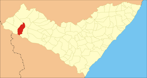
São José da Tapera
Municipality in Alagoas, Brazil
Distance: Approx. 65 meters
Latitude and longitude: -9.55777778,-37.38083333
São José da Tapera is a municipality located in the western of the Brazilian state of Alagoas. Its population was 32,405 (2020) and its area is 520 km².
Weather in this IP's area
overcast clouds
34 Celsius
34 Celsius
34 Celsius
34 Celsius
1013 hPa
34 %
1013 hPa
986 hPa
10000 meters
4.64 m/s
4.09 m/s
107 degree
88 %
