Country:
Region:
City:
Latitude and Longitude:
Time Zone:
Postal Code:
IP information under different IP Channel
ip-api
Country
Region
City
ASN
Time Zone
ISP
Blacklist
Proxy
Latitude
Longitude
Postal
Route
Luminati
Country
ASN
Time Zone
America/Chicago
ISP
Compuweb Communications Services Limited
Latitude
Longitude
Postal
IPinfo
Country
Region
City
ASN
Time Zone
ISP
Blacklist
Proxy
Latitude
Longitude
Postal
Route
db-ip
Country
Region
City
ASN
Time Zone
ISP
Blacklist
Proxy
Latitude
Longitude
Postal
Route
ipdata
Country
Region
City
ASN
Time Zone
ISP
Blacklist
Proxy
Latitude
Longitude
Postal
Route
Popular places and events near this IP address

Beeston, Nottinghamshire
Town in Nottinghamshire, England
Distance: Approx. 209 meters
Latitude and longitude: 52.927,-1.215
Beeston () is a town in the Borough of Broxtowe, Nottinghamshire, England, it is 3 miles south-west of Nottingham. To its north-east is the University of Nottingham's main campus, University Park. The headquarters of pharmaceutical and retail chemist group Boots are 0.6 miles (1 km) east of the centre of Beeston, on the border with Broxtowe and the City of Nottingham.
St John the Baptist Church, Beeston
Church in Nottinghamshire, England
Distance: Approx. 399 meters
Latitude and longitude: 52.92555556,-1.21666667
St. John the Baptist Church is an Anglican church in Beeston, Nottinghamshire, England. The church is Grade II listed by the Department for Digital, Culture, Media and Sport as it is a building of special architectural or historic interest.

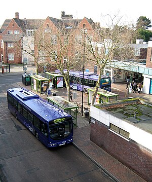
Beeston bus station
Former bus station that served the town of Beeston, in the English county of Nottinghamshire
Distance: Approx. 270 meters
Latitude and longitude: 52.926,-1.2145
Beeston bus station was a former bus station that served the town of Beeston, in the English county of Nottinghamshire. It was closed on 12 July 2015, when it was superseded by the nearby Beeston transport interchange, which includes services on the newly opened Nottingham Express Transit line 1 between Nottingham and Chilwell, as well as the bus routes that previously used the bus station. The bus station was in the town centre just off Station Road and consisted of six stands in total.

The Grange, Beeston
Distance: Approx. 492 meters
Latitude and longitude: 52.9248,-1.217357
The Grange is a Grade II listed building in Beeston, Nottinghamshire which formerly served as the area police station and is currently in use as apartments.

Anglo Scotian Mills
Distance: Approx. 375 meters
Latitude and longitude: 52.929628,-1.217463
The Anglo Scotian Mills is former lace factory in Beeston, Nottinghamshire. It is a Grade II listed building.

War Memorial Cross, Beeston
Grade II listed war memorial in Beeston, Nottinghamshire
Distance: Approx. 472 meters
Latitude and longitude: 52.924312,-1.215625
War Memorial Cross, Beeston is a Grade II listed structure in Beeston, Nottinghamshire.

Beeston transport interchange
Interchange between the trams of the Nottingham Express Transit network and local buses
Distance: Approx. 353 meters
Latitude and longitude: 52.925225,-1.214703
The Beeston transport interchange, also known as Beeston Centre tram stop, is an interchange between the trams of the Nottingham Express Transit (NET) network and local buses. It is in the centre of the town of Beeston in Nottinghamshire, England. The interchange is some 750 metres (0.5 mi) north-west of Beeston railway station.

Middle Street tram stop
Nottingham Express Transit tram stop
Distance: Approx. 254 meters
Latitude and longitude: 52.927943,-1.20871
Middle Street is a tram stop on the Nottingham Express Transit (NET) network in the town of Beeston. It is situated on street track within Middle Street and comprises a single island platform situated between the tracks. The stop is on line 1 of the NET, from Hucknall via the city centre to Beeston and Chilwell.
St John's Grove, Beeston
Conservation area in Nottinghamshire, England
Distance: Approx. 488 meters
Latitude and longitude: 52.926854,-1.219447
St John's Grove, Beeston is a conservation area in Beeston, Nottinghamshire.

High Road, Beeston
Street in Beeston, Nottinghamshire, England
Distance: Approx. 131 meters
Latitude and longitude: 52.9275,-1.21416667
High Road, Beeston is a pedestrianised shopping street in Beeston, Nottinghamshire. It runs from Beeston Square to Humber Road.

Station Road, Beeston
Distance: Approx. 447 meters
Latitude and longitude: 52.92416667,-1.21111111
Station Road is a street in Beeston, Nottinghamshire. It runs from its junction with High Road, in Beeston Square, to the town's railway station.

Beeston Town Hall
Municipal building in Beeston, Nottinghamshire, England
Distance: Approx. 426 meters
Latitude and longitude: 52.9271,-1.2186
Beeston Town Hall is a municipal building in Foster Avenue in Beeston, Nottinghamshire, England. The building was formerly the offices of Beeston and Stapleford Urban District Council and is now used by the Redeemer Church.
Weather in this IP's area
moderate rain
3 Celsius
0 Celsius
2 Celsius
4 Celsius
1005 hPa
89 %
1005 hPa
1001 hPa
10000 meters
3.09 m/s
60 degree
75 %
07:34:19
16:06:10
