Country:
 Germany
Region:
City:
Latitude and Longitude:
Time Zone:
Postal Code:
IP information under different IP Channel
ip-api
Country
Region
City
ASN
Time Zone
ISP
Blacklist
Proxy
Latitude
Longitude
Postal
Route
IPinfo
Country
Region
City
ASN
Time Zone
ISP
Blacklist
Proxy
Latitude
Longitude
Postal
Route
MaxMind
Country
Region
City
ASN
Time Zone
ISP
Blacklist
Proxy
Latitude
Longitude
Postal
Route
Luminati
Country
DEASN
Time Zone
Europe/Berlin
ISP
LWLcom GmbH
Latitude
Longitude
Postal
db-ip
Country
Region
City
ASN
Time Zone
ISP
Blacklist
Proxy
Latitude
Longitude
Postal
Route
ipdata
Country
Region
City
ASN
Time Zone
ISP
Blacklist
Proxy
Latitude
Longitude
Postal
Route
Popular places and events near this IP address
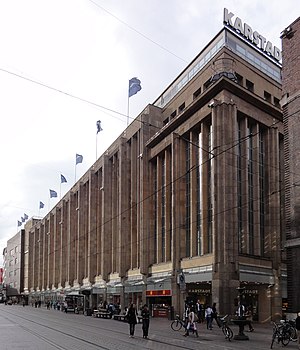
Karstadt (Bremen)
Department store in Bremen, Germany
Distance: Approx. 401 meters
Latitude and longitude: 53.07705556,8.80638889
Karstadt in Bremen is the largest department store in Bremen. It is located on Obernstrasse and Sögestrasse, in the old town in the city centre. Completed in 1932, the building was listed in 2010 as a notable example of department store architecture in the interwar period.

Stadtwaage (Bremen)
Distance: Approx. 415 meters
Latitude and longitude: 53.07634167,8.80546111
The Stadtwaage (weigh house) at No. 13 Langenstraße in Bremen (Germany) is the building in which the municipal weighing scales used to be housed. The facility was created in order to levy taxes and excise duties while protecting merchants and customers against fraud and dishonesty.

Weserburg
Modern art museum in Bremen, Germany
Distance: Approx. 374 meters
Latitude and longitude: 53.07638889,8.79888889
The Weserburg is a modern art museum in Bremen, Germany. Opened in 1991, it is located on the Teerhof peninsula next to the River Weser in an old factory building which was almost completely destroyed in the Second World War. Originally known as "New Museum Weserburg Bremen" (Neues Museum Weserburg Bremen), it was Europe's first "collectors' museum", in that it conserves no permanent collection but mounts changing exhibition of private collections.

Schlachte (Bremen)
Promenade along the east bank of the River Weser in Germany
Distance: Approx. 357 meters
Latitude and longitude: 53.07611111,8.80222222
The Schlachte is a promenade along the east bank of the River Weser in the old town of Bremen in the north of Germany. Once one of the city's harbours, it is now popular for its restaurants, beer gardens and river boats.

Essighaus
Distance: Approx. 392 meters
Latitude and longitude: 53.07638889,8.805
The Essighaus was an impressive gabled town house in the old town of Bremen in northern Germany. One of the city's finest examples of Renaissance architecture, it was almost completely destroyed by bombing in 1943. The entrance flanked by projecting bay windows is the only part of the building which has been restored.

Teerhof
Peninsula between the River Weser and the Kleine Weser in Germany
Distance: Approx. 374 meters
Latitude and longitude: 53.07638889,8.79888889
The Teerhof is a peninsula between the River Weser and the Kleine Weser, opposite the city centre of Bremen, Germany. It was first mentioned in 1624 as "Theerhof" when it was the northernmost part of an island. Today it consists mainly of residential buildings and the Weserburg modern art museum.

Schlachte Great Crane
Distance: Approx. 406 meters
Latitude and longitude: 53.07571667,8.80280278
The Schlachte Cranes were important to the port of Bremen as they enabled heavy loads to be moved off boats on the River Weser. The Schlachte became an important harbour for the city after silting prevented the use of the Balge as a harbour. Today, only the foundations of a 19th-century crane remain on the Weser waterfront.

Langenstraße (Bremen)
Historical street in the old town of Bremen, Germany
Distance: Approx. 392 meters
Latitude and longitude: 53.07638889,8.805
The Langenstraße is a historical street in the old town of Bremen in the north of Germany. First mentioned in 1234, it is one of Bremen's oldest streets and one of the most important for the city's merchants. It no doubt originated at the time when the first settlements grew up on the north bank of the Balge.

Suding & Soeken building, Bremen
Building in Bremen, Germany
Distance: Approx. 268 meters
Latitude and longitude: 53.07694444,8.8025
The Suding & Soeken building (German: Kontorhaus Suding und Soeken) is a gabled house at No. 28 Langenstraße in Bremen, Germany. Referred to as a Kaufmannshaus or Kontorhaus, it is one of the city's few historic merchant houses to survive the war undamaged.

Am Wall Windmill
German building
Distance: Approx. 363 meters
Latitude and longitude: 53.0802,8.8069
The Am Wall Windmill (Herdentorswallmühle or Mühle am Wall) is a windmill in Bremen, Germany. It was fully built in 1898. The building is open to visitors and it has a restaurant.

Unser Lieben Frauen Kirchhof
Distance: Approx. 472 meters
Latitude and longitude: 53.07686111,8.80746667
Unser Lieben Frauen Kirchhof (German: Our Dear Lady's Churchyard) is a central square in Bremen between the Bremer Marktplatz, Obernstraße, Sögestraße and the Domshof. The square is used as a flower market. The appearance of the square is quite consistent: sandstone (as in the church), dark brick (as in the Rathaus) and clinker brick.

St. Ansgarii Church
Distance: Approx. 138 meters
Latitude and longitude: 53.078468,8.803213
St. Ansgarii Church was a medieval Brick Gothic church in Bremen. The 97-meter-high tower was the tallest landmark of the city for centuries.
Weather in this IP's area
broken clouds
14 Celsius
14 Celsius
13 Celsius
14 Celsius
999 hPa
94 %
999 hPa
998 hPa
10000 meters
4.63 m/s
130 degree
75 %
07:38:52
18:45:21