Country:
 Ukraine
Region:
City:
Latitude and Longitude:
Time Zone:
Postal Code:
IP information under different IP Channel
ip-api
Country
Region
City
ASN
Time Zone
ISP
Blacklist
Proxy
Latitude
Longitude
Postal
Route
IPinfo
Country
Region
City
ASN
Time Zone
ISP
Blacklist
Proxy
Latitude
Longitude
Postal
Route
MaxMind
Country
Region
City
ASN
Time Zone
ISP
Blacklist
Proxy
Latitude
Longitude
Postal
Route
Luminati
Country
UAASN
Time Zone
Europe/Kyiv
ISP
Dataline LLC
Latitude
Longitude
Postal
db-ip
Country
Region
City
ASN
Time Zone
ISP
Blacklist
Proxy
Latitude
Longitude
Postal
Route
ipdata
Country
Region
City
ASN
Time Zone
ISP
Blacklist
Proxy
Latitude
Longitude
Postal
Route
Popular places and events near this IP address

Zhytomyr
City and administrative center of Zhytomyr Oblast, Ukraine
Distance: Approx. 772 meters
Latitude and longitude: 50.25,28.66666667
Zhytomyr (Ukrainian: Житомир [ʒɪˈtɔmɪr] ; see below for other names) is a city in the north of the western half of Ukraine. It is the administrative center of Zhytomyr Oblast (province), as well as the administrative center of the surrounding Zhytomyr urban hromada (commune) and Zhytomyr Raion (district). Moreover Zhytomyr consists of two urban districts: Bohunskyi District and Koroliovskyi District (named in honour of Sergey Korolyov).

Volhynia Governorate
1795–1925 unit of Russia
Distance: Approx. 72 meters
Latitude and longitude: 50.2544,28.6578
Volhynia Governorate, also known as Volyn Governorate, was an administrative-territorial unit (guberniya) of the Southwestern Krai of the Russian Empire. It consisted of an area of 71,736 square kilometres (27,697 sq mi) and a population of 2,989,482 inhabitants. The governorate bordered Grodno and Minsk Governorates to the north, Kiev Governorate to the east, Podolia Governorate to the south, Lublin and Siedlce Governorates, and after 1912, Kholm Governorate and Austria to the west.
Roman Catholic Diocese of Kyiv-Zhytomyr
Roman Catholic diocese in Ukraine
Distance: Approx. 285 meters
Latitude and longitude: 50.2548,28.6547
The Roman Catholic Diocese of Kyiv-Zhytomyr (Latin: Dioecesis Kioviensis-Zytomeriensis) is a suffragan diocese of the Latin Church of the Catholic Church in Ukraine in ecclesiastical province of the Metropolitan Archdiocese of Lviv of the Latins. Its cathedral episcopal see is the St. Sophia's Cathedral, Zhytomyr.
Huiva, Zhytomyr Oblast
Urban locality in Zhytomyr Oblast, Ukraine
Distance: Approx. 4883 meters
Latitude and longitude: 50.21083333,28.65861111
Huiva (Ukrainian: Гуйва) is an urban-type settlement in Zhytomyr Raion, Zhytomyr Oblast, Ukraine. Population: 1,656 (2022 estimate) In 2001, population was 698.

Novohuivynske
Urban locality in Zhytomyr Oblast, Ukraine
Distance: Approx. 5822 meters
Latitude and longitude: 50.20638889,28.69
Novohuivynske (Ukrainian: Новогуйвинське) is an urban-type settlement in Zhytomyr Raion, Zhytomyr Oblast, Ukraine. Population: 5,240 (2022 estimate) In 2001, population was 5,267.

Huiva (river)
River in Ukraine
Distance: Approx. 3832 meters
Latitude and longitude: 50.2246,28.6326
The Huiva (Ukrainian: Гуйва, Russian: Гуйва Guyva) is a river of northern Ukraine, flowing through the territory of Khmilnyk Raion of Vinnytsia Oblast and Andrushivka Raion and Zhytomyr Raion of Zhytomyr Oblast. It is a right tributary of the Teteriv. The river has a length of 97 km and basin area of 1505 km ².
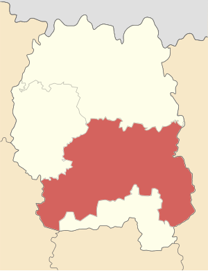
Zhytomyr Raion
Subdivision of Zhytomyr Oblast, Ukraine
Distance: Approx. 5610 meters
Latitude and longitude: 50.20472222,28.64861111
Zhytomyr Raion (Ukrainian: Житомирський район) is a raion (district) of Zhytomyr Oblast, northern Ukraine. Its administrative centre is located at Zhytomyr. The raion covers an area of 1,441 square kilometres (556 sq mi).
Zhytomyr International Airport
Airport in Zhytomyr Oblast, Ukraine
Distance: Approx. 5954 meters
Latitude and longitude: 50.27055556,28.73861111
Zhytomyr International Airport (Ukrainian: Міжнародний аеропорт «Житомир») (IATA: ZTR, ICAO: UKKV) is an airport in Zhytomyr, Ukraine.

Tsentralnyi Stadion (Zhytomyr)
Distance: Approx. 1200 meters
Latitude and longitude: 50.24611111,28.66888889
Central Stadium (Ukrainian: Центральний cтадіон, Tsentralnyi stadion) is a multi-purpose stadium in Zhytomyr, Ukraine. The decent size stadium had over 20,000 seats before reconstruction (21,928). However after demolition of unsafe terraces the stadium hosts 5,928 spectators.

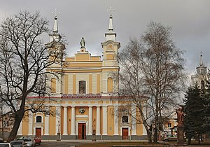
Saint Sophia Cathedral, Zhytomyr
Church in Zhytomyr, Ukraine
Distance: Approx. 308 meters
Latitude and longitude: 50.255,28.6544
Saint Sophia Cathedral (Ukrainian: Кафедральний собор св. Софії, Polish: Katedra Świętej Zofii) is a Catholic church that serves as the principal church of the Roman Catholic Diocese of Kyiv-Zhytomyr, Ukraine. The temple was built between 1746 and 1748 and was founded by Bishop Samuel Jan Ozga.

Polissia National University
Education organization in Zhytomyr, Ukraine
Distance: Approx. 978 meters
Latitude and longitude: 50.24861,28.66861
Polissia National University (Ukrainian: Поліський національний університет), known as the Zhytomyr National Agroecological University prior to 2020, is a university in Zhytomyr, Ukraine. The University provides specialists in the majority of national economic sectors in the Ukrainian Polesia (Zhytomyr, Rivne and Volyn oblasts). The university has some seven thousand students and is divided into eight faculties (agronomy, technology of animal production and processing, veterinary medicine, agricultural engineering and energetics, ecology and law, forestry, accounting and finance, economics and management) and 42 departments.
Zhytomyr urban hromada
Urban hromada of Zhytomyr Oblast, Ukraine
Distance: Approx. 772 meters
Latitude and longitude: 50.25,28.66666667
Zhytomyr urban territorial hromada (Ukrainian: Житомирська міська територіальна громада, romanized: Zhytomyrska miska terytorialna hromada) is one of Ukraine's hromadas, located in Zhytomyr Raion in Zhytomyr Oblast. Its capital is the city of Zhytomyr. The hromada has an area of 91.5 km2 (35.3 sq mi), as well as a population of 275,412 (as of 2023).
Weather in this IP's area
broken clouds
5 Celsius
4 Celsius
5 Celsius
5 Celsius
1031 hPa
68 %
1031 hPa
1003 hPa
10000 meters
1.98 m/s
3.52 m/s
70 degree
67 %
07:32:35
18:08:01