Country:
Region:
City:
Latitude and Longitude:
Time Zone:
Postal Code:
IP information under different IP Channel
ip-api
Country
Region
City
ASN
Time Zone
ISP
Blacklist
Proxy
Latitude
Longitude
Postal
Route
Luminati
Country
Region
eng
City
bournemouth
ASN
Time Zone
Europe/London
ISP
WideFM Ltd
Latitude
Longitude
Postal
IPinfo
Country
Region
City
ASN
Time Zone
ISP
Blacklist
Proxy
Latitude
Longitude
Postal
Route
db-ip
Country
Region
City
ASN
Time Zone
ISP
Blacklist
Proxy
Latitude
Longitude
Postal
Route
ipdata
Country
Region
City
ASN
Time Zone
ISP
Blacklist
Proxy
Latitude
Longitude
Postal
Route
Popular places and events near this IP address

Bournemouth International Centre
English events venue
Distance: Approx. 460 meters
Latitude and longitude: 50.71666667,-1.87805556
The Bournemouth International Centre (commonly known as the BIC ) in Bournemouth, Dorset, was opened in September 1984. It is one of the largest venues for conferences, exhibitions, entertainment and events in southern England. Additionally, it is well known for hosting national conferences of major British political parties and trade unions.

South East Dorset conurbation
Population centre in Southern England
Distance: Approx. 540 meters
Latitude and longitude: 50.72,-1.87
The South East Dorset conurbation (also known as the South Dorset conurbation, Poole-Bournemouth urban area and Bournemouth urban area) is a multi-centred conurbation on the south coast of Dorset in England.

Russell-Cotes Art Gallery & Museum
Distance: Approx. 270 meters
Latitude and longitude: 50.7176,-1.8707
The Russell-Cotes Museum (formally, the Russell-Cotes Art Gallery & Museum) is an art gallery and museum in Bournemouth, England. A Grade II* listed building originally known as East Cliff Hall, it is located on the top of the East Cliff, next to the Royal Bath Hotel.

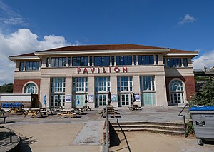
Pavilion Theatre, Bournemouth
Distance: Approx. 340 meters
Latitude and longitude: 50.71777778,-1.87472222
The Pavilion Theatre and Ballroom is a concert hall in Bournemouth. It opened in 1929 and has been redesigned several times since.

East Cliff Railway
Distance: Approx. 549 meters
Latitude and longitude: 50.717989,-1.865364
The East Cliff Railway, or East Cliff Lift, is a funicular railway located on the East Cliff of the English seaside resort of Bournemouth. The line serves to link the seaside promenade and beach with the cliff top and the town behind. Following a landslip in April 2016 which damaged the line and associated structures, the railway is out of use indefinitely.
1993 Bournemouth bombing
Distance: Approx. 399 meters
Latitude and longitude: 50.71666667,-1.86666667
On Friday 13 August 1993, 6 out of 7 explosive devices planted by the Provisional Irish Republican Army (IRA), went off at locations within Bournemouth, Dorset, including shops and at the pier. Four devices were incendiary devices, whilst the other two were explosive devices. A larger explosive device, that was believed to have been able to destroy the pier, was located underneath the theatre on the pier and made safe by the British Army's bomb disposal team.
Uncle Tom and Little Eva (painting)
British painting
Distance: Approx. 270 meters
Latitude and longitude: 50.7176,-1.8707
Uncle Tom and Little Eva is an oil on canvas painted by Edwin Longsden Long in 1866. It depicts a scene from the novel Uncle Tom's Cabin. The painting is kept at Russell-Cotes Art Gallery & Museum.

Royal Bath Hotel
Distance: Approx. 260 meters
Latitude and longitude: 50.7176,-1.8725
The Royal Bath Hotel is a building in Bournemouth, Dorset. It is owned by Britannia Hotels and is regarded to be the town's most famous hotel. Since 1974, the hotel has been a Grade II listed building.

The Waterfront, Bournemouth
Distance: Approx. 238 meters
Latitude and longitude: 50.71669444,-1.87446111
The Waterfront was a leisure complex on the seafront in Bournemouth, England. It contained an IMAX cinema and restaurants.

Bournemouth Gardens, England
Garden in Dorset, England
Distance: Approx. 360 meters
Latitude and longitude: 50.71736944,-1.87583333
Bournemouth Gardens are Grade II listed gardens in the town of Bournemouth, Dorset, England. Created in the nineteenth century, the gardens follow the towns eponymous River Bourne three kilometres from the historic boundary with Poole south-eastwards into Bournemouth Town Centre. The Gardens are home to a number of significant Bournemouth landmarks and listed buildings such as; the Town Hall, the War Memorial, St.

Royal Exeter Hotel
Hotel in Bournemouth, Dorset, England
Distance: Approx. 573 meters
Latitude and longitude: 50.71744,-1.8793
The Royal Exeter Hotel is a Grade II listed building in Bournemouth, Dorset. It stands opposite the Bournemouth International Centre.

2023 Bournemouth beach incident
Incident in Bournemouth, UK
Distance: Approx. 266 meters
Latitude and longitude: 50.716132,-1.875442
On 31 May 2023, two people died and eight others were injured on the beach in Bournemouth, Dorset, England. A man was arrested on suspicion of manslaughter, but following an investigation, police determined that no criminal offence had been committed in relation to the incident.
Weather in this IP's area
overcast clouds
10 Celsius
9 Celsius
9 Celsius
11 Celsius
1024 hPa
89 %
1024 hPa
1022 hPa
8000 meters
4.12 m/s
70 degree
100 %
07:11:27
16:31:07
