Country:
 USA
USARegion:
City:
Latitude and Longitude:
Time Zone:
Postal Code:
IP information under different IP Channel
ip-api
Country
Region
City
ASN
Time Zone
ISP
Blacklist
Proxy
Latitude
Longitude
Postal
Route
IPinfo
Country
Region
City
ASN
Time Zone
ISP
Blacklist
Proxy
Latitude
Longitude
Postal
Route
MaxMind
Country
Region
City
ASN
Time Zone
ISP
Blacklist
Proxy
Latitude
Longitude
Postal
Route
Luminati
Country
USRegion
ny
City
cambriaheights
ASN
Time Zone
America/New_York
ISP
Omer GOLGELI
Latitude
Longitude
Postal
db-ip
Country
Region
City
ASN
Time Zone
ISP
Blacklist
Proxy
Latitude
Longitude
Postal
Route
ipdata
Country
Region
City
ASN
Time Zone
ISP
Blacklist
Proxy
Latitude
Longitude
Postal
Route
Popular places and events near this IP address

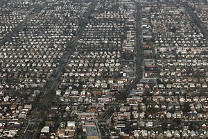
St. Albans, Queens
Neighborhood in New York City
Distance: Approx. 1851 meters
Latitude and longitude: 40.69,-73.765
St. Albans is a residential neighborhood in the southeastern portion of the New York City borough of Queens. It is bordered by Jamaica to the northwest, Hollis to the north, Queens Village to the northeast, Cambria Heights to the east, Laurelton to the southeast, Springfield Gardens to the south, and South Jamaica to the southwest.

Laurelton, Queens
Neighborhood in New York City
Distance: Approx. 1589 meters
Latitude and longitude: 40.675,-73.745
Laurelton is a largely middle-class neighborhood in the New York City borough of Queens and part of the former town of Jamaica. Merrick Boulevard, which bisects the community in a generally east–west direction, forms its commercial spine. It is bounded by Springfield Boulevard to the west, 121st Avenue to the north, Laurelton Parkway to the east, and Conduit Avenue to the south.
Cambria Heights, Queens
Neighborhood in New York City
Distance: Approx. 940 meters
Latitude and longitude: 40.695,-73.735
Cambria Heights is a residential neighborhood in the southeastern portion of the New York City borough of Queens. It is bounded by Springfield Boulevard and Francis Lewis Boulevard to the west, the Elmont, Nassau County border on the east, Queens Village to the north, St. Albans to the west, and Montefiore Cemetery and Laurelton, Springfield Gardens, and Rosedale to the south.
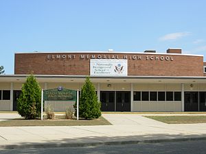
Elmont Memorial High School
High school in Nassau County, New York, United States
Distance: Approx. 2273 meters
Latitude and longitude: 40.69722222,-73.71833333
Elmont Memorial High School (EMHS) is a co-educational, public high school founded in 1956 for students in grades 7–12 in the hamlet of Elmont, Long Island, New York, in Nassau County, United States. The school is one of five secondary schools of the Sewanhaka Central High School District. As of the 2018–19 school year, the school had an enrollment of 1,640 students and 109.0 classroom teachers (on an FTE basis), for a student–teacher ratio of 15.0:1.

St. Albans station (LIRR)
Long Island Rail Road station in Queens, New York
Distance: Approx. 1896 meters
Latitude and longitude: 40.691052,-73.765426
St. Albans is a station on the Long Island Rail Road's Montauk Branch in St. Albans, Queens, New York on the southwest corner of Linden Boulevard and Montauk Place, although the segment of Montauk Place that once intersected with Linden Boulevard has been abandoned and fenced off.

Springfield Boulevard
Boulevard in Queens, New York
Distance: Approx. 2097 meters
Latitude and longitude: 40.70774722,-73.73878056
Springfield Boulevard is a major north/south roadway that runs through the eastern section of Queens, New York. It is 7.8 miles (12.6 km) long and goes from Northern Boulevard in Bayside, to 147th Avenue in Springfield Gardens. Springfield Boulevard runs through Bayside, Oakland Gardens, Hollis Hills, Queens Village, Cambria Heights, Laurelton, Springfield Gardens and along the eastern border of St.

Ohel (Chabad-Lubavitch)
Graves of the last two Lubavitcher Rebbes in New York City
Distance: Approx. 599 meters
Latitude and longitude: 40.686,-73.7374
The Ohel (Hebrew: אהל, lit. 'tent') is an ohel (Jewish monumental tomb) in Cambria Heights, Queens, New York City, where Rabbi Menachem Mendel Schneerson and his father-in-law Rabbi Yosef Yitzchok Schneersohn, the two most recent rebbes of the Chabad-Lubavitch dynasty, are buried. Both Jews and non-Jews visit The Ohel for prayer, and approximately 50,000 people make an annual pilgrimage there on the anniversary of Schneerson's death.

Montefiore Cemetery
Jewish cemetery in Queens, New York
Distance: Approx. 394 meters
Latitude and longitude: 40.68583333,-73.74166667
Montefiore Cemetery, also known as Old Montefiore Cemetery, is a Jewish cemetery in Springfield Gardens, Queens, New York, established in 1908. The cemetery is called by several names, including Old Montefiore, Springfield, or less commonly, just Montefiore. More than 150,000 have been buried there.
Springfield Gardens station
Former Long Island Rail Road station
Distance: Approx. 1847 meters
Latitude and longitude: 40.675464,-73.75538
Springfield Gardens was an island platform station that existed along the Babylon-Montauk Branch of the Long Island Rail Road, in the Springfield Gardens, Queens section of Queens, New York City. The station was located between St. Albans and Rosedale Stations, north of Springfield Junction.
Andrew Jackson High School (Queens)
High school in New York, U.S.A.
Distance: Approx. 1046 meters
Latitude and longitude: 40.69830556,-73.74616667
Andrew Jackson High School is a defunct comprehensive high school in the Cambria Heights section in southeastern Queens, New York. The school was opened in 1937, and named after former United States President Andrew Jackson. However, the city closed down the school in 1994.
Higbie Avenue station
Long Island Railroad station in Queens, New York
Distance: Approx. 2364 meters
Latitude and longitude: 40.672328,-73.760102
Higbie Avenue was a railroad station along the Atlantic Branch of the Long Island Rail Road, in Queens, New York City. The station was located on 140th Avenue (formerly Higbie Avenue) and Edgewood Avenue in the Springfield section of Queens, New York City between Locust Manor and Laurelton stations.
Masjid Hamza
Islamic center in New York city
Distance: Approx. 2305 meters
Latitude and longitude: 40.68584167,-73.71615833
Masjid Hamza is a mosque and Islamic community center located at 200 Stuart Avenue, Valley Stream, New York. It has a K–6 school system called "Hamza Academy", and has a mosque. The masjid is located fifteen minutes away from John F. Kennedy International Airport and serves about 1,400 families.
Weather in this IP's area
broken clouds
21 Celsius
22 Celsius
20 Celsius
22 Celsius
1015 hPa
83 %
1015 hPa
1014 hPa
10000 meters
4.63 m/s
40 degree
75 %
06:39:03
18:58:59