45.153.205.185 - IP Lookup: Free IP Address Lookup, Postal Code Lookup, IP Location Lookup, IP ASN, Public IP
Country:
 France
Region:
City:
Location:
Time Zone:
Postal Code:
ISP:
ASN:
language:
User-Agent:
Proxy IP:
Blacklist:
IP information under different IP Channel
ip-api
Country
Region
City
ASN
Time Zone
ISP
Blacklist
Proxy
Latitude
Longitude
Postal
Route
db-ip
Country
Region
City
ASN
Time Zone
ISP
Blacklist
Proxy
Latitude
Longitude
Postal
Route
IPinfo
Country
Region
City
ASN
Time Zone
ISP
Blacklist
Proxy
Latitude
Longitude
Postal
Route
IP2Location
45.153.205.185Country
frRegion
bourgogne-franche-comte
City
besancon
Time Zone
Europe/Paris
ISP
Language
User-Agent
Latitude
Longitude
Postal
ipdata
Country
Region
City
ASN
Time Zone
ISP
Blacklist
Proxy
Latitude
Longitude
Postal
Route
Popular places and events near this IP address

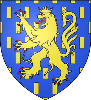
Arrondissement of Besançon
Arrondissement in Bourgogne-Franche-Comté, France
Distance: Approx. 909 meters
Latitude and longitude: 47.25,6.03
The arrondissement of Besançon is an arrondissement of France in the Doubs department in the Bourgogne-Franche-Comté region. It has 252 communes. Its population is 253,510 (2021), and its area is 1,926.4 km2 (743.8 sq mi).
University of Franche-Comté
French public university based in Besançon
Distance: Approx. 976 meters
Latitude and longitude: 47.24055556,6.0225
The University of Franche-Comté (UFC) is a pluridisciplinary public French university located in Besançon, Franche-Comté, with decentralized campuses in Belfort, Montbéliard, Vesoul and Lons-le-Saunier. It is a founding member of the community of universities and institutions University of Burgundy - Franche-Comté (COMUE UBFC), headquartered in Besançon and which federates universities and other higher learning institutes in the Bourgogne-Franche-Comté region. With 28 research labs, 667 PhD students and 788 research professors in 2016–2017, the University of Franche-Comté is well represented in the research community.

Jardin botanique de Besançon
Botanical garden in Doubs, Franche-Comté, France
Distance: Approx. 670 meters
Latitude and longitude: 47.2433,6.0145
The Jardin botanique de Besançon (Botanical Garden of Besançon), more formally the Jardin botanique de l'Université de Franche-Comté et de la Ville de Besançon, is a botanical garden located on the Place du Maréchal Leclerc, Besançon, Doubs, Franche-Comté, France. It is operated by the University of Franche-Comté and open daily; admission is free. Besançon's first botanical garden was established in 1580, but since then the garden has moved across more than 10 sites in the city, assuming its current location in 1957.

Église de la Madeleine (Besançon)
Distance: Approx. 983 meters
Latitude and longitude: 47.24,6.01916667
The église Sainte-Madeleine is a neoclassical 18th century hall church in the Battant district of Besançon, France, dedicated to Saint Mary Magdalene. Antoine-Pierre II de Grammont, the archbishop of Besançon, had it built from 1746 to 1766 to plans by the architect Nicolas Nicole.

Les Chaprais
Distance: Approx. 807 meters
Latitude and longitude: 47.2475,6.02861111
The Chaprais or Chaprais is a district of Besançon, which was developed from the second half of the 19th century.

Battant (Besançon)
Distance: Approx. 923 meters
Latitude and longitude: 47.24055556,6.01944444
Battant is one of the oldest parts of Besançon, Doubs, France, and has been under architectural protection since 1964. It is situated on the right bank of the river Doubs, north of the ox-bow that encircles the center of the city. A bridge across the Doubs joins the two quarters Battant and La Boucle (The Oxbow), via the Vauban quay and Jouffroy d'Abbans Place.

Montrapon
Distance: Approx. 570 meters
Latitude and longitude: 47.2519,6.0121
Montrapon, with Fontaine-Écu are two sectors forming an area located in the north of Besançon (France). In 1990, they counted approximately 10,000 inhabitants. The Fort of Justices was located in this area.

Synagogue of Besançon
Synagogue located in Besançon, France
Distance: Approx. 941 meters
Latitude and longitude: 47.24055556,6.02083333
The Synagogue of Besançon is a Jewish congregation and synagogue, located at 23 Quai de Strasbourg, in the Battant area, near the old part of town, in the city of Besançon, in the Bourgogne-Franche-Comté region of France. The stone synagogue was built in 1869 and was inaugurated on 18 November. A Jewish community formed in Free Imperial City of Besançon in the 14th century, after the expulsion of Jews from the Kingdom of France, but was forced to leave shortly thereafter.
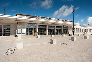
Besançon-Viotte station
French railway station
Distance: Approx. 356 meters
Latitude and longitude: 47.24694444,6.02194444
Besançon-Viotte is the main railway station located in Besançon, Doubs, eastern France. The station was opened in 1855 and is located on the Dole–Belfort railway, Besançon–Le Locle railway and Besançon-Viotte-Vesoul railway. The train services are operated by SNCF. Besançon Franche-Comté TGV is a high speed station located 10km north of Besançon.

Siege of Besançon
Siege during the Franco-Dutch War
Distance: Approx. 696 meters
Latitude and longitude: 47.2431,6.0219
The siege of Besançon took place from 25 April to 22 May 1674 during the Franco-Dutch War, when French forces nominally led by Louis XIV of France invaded Franche-Comté, then part of the Spanish Empire. Siege works were supervised by the duc d'Enghien, eldest son of le Grand Condé, and French military engineer Sébastien Le Prestre de Vauban. The defenders were commanded by Vaudémont but the town's isolated position meant they could only delay capture.

Battle of Besançon
1575 battle of the French Wars of Religion
Distance: Approx. 702 meters
Latitude and longitude: 47.24305556,6.02194444
The Battle of Besançon (21 June 1575) was a sectarian conflict between the Protestants and Catholics in the French city of Besançon in the region of Franche-Comté. Prior to the battle, the Huguenots, accused of heresy, had been expelled from the city and fled to the County of Montbéliard and Switzerland; the outcasts formed an army and planned an attempt to retake Besançon and turn the city into a stronghold of the Protestant Reformation. By the time the armed Protestants had reached the city of Besançon however, their army had dwindled because of several mishaps.

Radio BIP
Radio station in Besançon
Distance: Approx. 523 meters
Latitude and longitude: 47.2477554,6.024849
Radio BIP is a French local and associative FM broadcasting station, active in Besançon and Bourgogne-Franche-Comté. The acronym BIP stands for Bisontine, Indépendante et Populaire, meaning "Bisontine, independent and popular". After originally operating as a pirate radio station from 1977 to 1978, it was refounded in 1981 as a "free radio".
Weather in this IP's area
clear sky
-2 Celsius
-6 Celsius
-2 Celsius
-2 Celsius
1038 hPa
91 %
1038 hPa
997 hPa
10000 meters
2.37 m/s
3.6 m/s
58 degree