Country:
 Netherlands
Region:
City:
Latitude and Longitude:
Time Zone:
Postal Code:
IP information under different IP Channel
ip-api
Country
Region
City
ASN
Time Zone
ISP
Blacklist
Proxy
Latitude
Longitude
Postal
Route
IPinfo
Country
Region
City
ASN
Time Zone
ISP
Blacklist
Proxy
Latitude
Longitude
Postal
Route
MaxMind
Country
Region
City
ASN
Time Zone
ISP
Blacklist
Proxy
Latitude
Longitude
Postal
Route
Luminati
Country
NLASN
Time Zone
Europe/Amsterdam
ISP
BIT BV
Latitude
Longitude
Postal
db-ip
Country
Region
City
ASN
Time Zone
ISP
Blacklist
Proxy
Latitude
Longitude
Postal
Route
ipdata
Country
Region
City
ASN
Time Zone
ISP
Blacklist
Proxy
Latitude
Longitude
Postal
Route
Popular places and events near this IP address

Doetinchem
Municipality in Gelderland, Netherlands
Distance: Approx. 1945 meters
Latitude and longitude: 51.96666667,6.3
Doetinchem (Dutch pronunciation: [ˈdutɪŋxəm] ; Low Saxon: Deutekem) is a city and municipality in the east of the Netherlands. It is situated along the Oude IJssel (Old IJssel) river in a part of the province of Gelderland called the Achterhoek. The municipality had a population of 58,270 in 2021 and consists of an area of 79.66 km2 (30.76 sq mi) of which 0.61 km2 (0.24 sq mi) is water.
Hummelo en Keppel
Former municipality in Gelderland, Netherlands
Distance: Approx. 4069 meters
Latitude and longitude: 52,6.23333333
Hummelo en Keppel is a former municipality in the Dutch province of Gelderland. It was created in 1818, when the municipalities of Hummelo and Keppel merged, and existed until 2005, when the area became a part of the new municipality of Bronckhorst.
Villa Bouchina
Dutch church that housed Jews in 1943
Distance: Approx. 1111 meters
Latitude and longitude: 51.96972222,6.28888889
Villa Bouchina was the parsonage of the Christian Reformed Church in the City of Doetinchem, Province of Gelderland. From February 27 until April 21, 1943, it was used temporarily to house nine Jews, including three children, who were known as Mussert Jews.

Ambt Doetinchem
Former Municipality in Gelderland, Netherlands
Distance: Approx. 2103 meters
Latitude and longitude: 51.96583333,6.30194444
Ambt Doetinchem is a former municipality in the Dutch province of Gelderland. It consisted of the countryside surrounding the city of Doetinchem, which belonged to the separate municipality of Stad Doetinchem. Ambt Doetinchem was a separate municipality between 1818 and 1920, when it merged with Stad Doetinchem.
Stad Doetinchem
Distance: Approx. 1350 meters
Latitude and longitude: 51.965529,6.288943
Stad Doetinchem is a former municipality in the Dutch province of Gelderland. It consisted of the city of Doetinchem and its immediate surroundings. The larger surrounding countryside was a separate municipality, called Ambt Doetinchem.

Doetinchem railway station
Railway station in the Netherlands
Distance: Approx. 2220 meters
Latitude and longitude: 51.95833333,6.29527778
Doetinchem is a railway station located in Doetinchem, Netherlands. The station was opened on 15 July 1885 and is located on the Winterswijk–Zevenaar railway. The station is operated by Arriva and Breng.

Doetinchem De Huet railway station
Railway station in the Netherlands
Distance: Approx. 1813 meters
Latitude and longitude: 51.95916667,6.26027778
Doetinchem De Huet is a railway station located in western Doetinchem, Netherlands. The station lies between the quarters De Huet and Dichteren. The station was opened on 2 June 1985 as a replacement for the previous station Doetinchem West (earlier: Doetinchem-Wijnbergen (1885–1965)), which was open from 1885 to 1985.
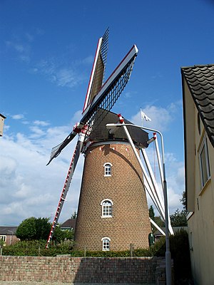
Aurora, Dichteren
Dutch windmill
Distance: Approx. 2032 meters
Latitude and longitude: 51.955,6.27138889
Aurora is a tower mill in Dichteren, Gelderland, Netherlands which was built in 1870 and has been restored to working order. The mill is listed as a Rijksmonument.

Benninkmolen, Doetinchem
Dutch windmill
Distance: Approx. 3649 meters
Latitude and longitude: 51.96666667,6.32583333
Benninkmolen is a smock mill in Doetinchem, Gelderland, Netherlands which was built in 1921 and has been restored to working order. The mill is listed as a Rijksmonument.

Doetinchem Stadion railway station
Closed railway station in the Netherlands
Distance: Approx. 3139 meters
Latitude and longitude: 51.9551,6.3088
Doetinchem Stadion was a stop on the Winterswijk–Zevenaar railway in Doetinchem, Netherlands. It was for spectators going to the De Graafschap football club's De Vijverberg stadium. It was opened in 1992 and was only used for important matches.
Oosseld
District of Doetinchem in Gelderland, Netherlands
Distance: Approx. 3757 meters
Latitude and longitude: 51.9489,6.3117
Oosseld or Oosselt, also known as De Bloemenbuurt is a district within, and former hamlet (buurtschap) of the municipality of Doetinchem, located in the Dutch province of Gelderland. Until 1919 Oosseld belonged to the municipality Ambt Doetinchem. Koekendaal and Ter Gun are also part of Ooseld.

Keppel Castle
17th century Dutch castle
Distance: Approx. 3914 meters
Latitude and longitude: 51.99353889,6.22713889
Keppel Castle is a castle in the town of Laag-Keppel in the municipality of Bronckhorst, in the Dutch province of Gelderland. The castle stands on an island between two branches of the Oude IJssel. The current building was rebuilt in the 17th century after it was destroyed in 1582.
Weather in this IP's area
overcast clouds
20 Celsius
20 Celsius
17 Celsius
22 Celsius
1013 hPa
84 %
1013 hPa
1011 hPa
10000 meters
0.45 m/s
1.34 m/s
290 degree
88 %
08:05:05
18:34:34