45.149.37.11 - IP Lookup: Free IP Address Lookup, Postal Code Lookup, IP Location Lookup, IP ASN, Public IP
Country:
 France
Region:
City:
Location:
Time Zone:
Postal Code:
ISP:
ASN:
language:
User-Agent:
Proxy IP:
Blacklist:
IP information under different IP Channel
ip-api
Country
Region
City
ASN
Time Zone
ISP
Blacklist
Proxy
Latitude
Longitude
Postal
Route
db-ip
Country
Region
City
ASN
Time Zone
ISP
Blacklist
Proxy
Latitude
Longitude
Postal
Route
IPinfo
Country
Region
City
ASN
Time Zone
ISP
Blacklist
Proxy
Latitude
Longitude
Postal
Route
IP2Location
45.149.37.11Country
frRegion
provence-alpes-cote-d'azur
City
auriol
Time Zone
Europe/Paris
ISP
Language
User-Agent
Latitude
Longitude
Postal
ipdata
Country
Region
City
ASN
Time Zone
ISP
Blacklist
Proxy
Latitude
Longitude
Postal
Route
Popular places and events near this IP address

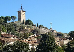
Auriol, Bouches-du-Rhône
Commune in Provence-Alpes-Côte d'Azur, France
Distance: Approx. 422 meters
Latitude and longitude: 43.3681,5.6361
Auriol (French pronunciation: [oʁjɔl]; Occitan: Auriòu) is a commune in the Huveaune valley in the Bouches-du-Rhône department in the Provence-Alpes-Côte d'Azur region of Southern France. The commune has been awarded one flower by the National Council of Towns and Villages in Bloom in the Competition of cities and villages in Bloom. Located west of Roquevaire and northwest of Aubagne, it will be served by two stations of the Aubagne tramway when the northern Line T extension opens in 2023.

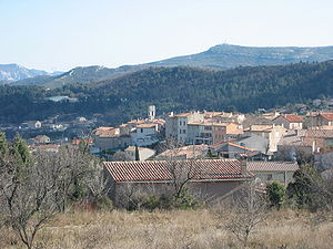
Peypin
Commune in Provence-Alpes-Côte d'Azur, France
Distance: Approx. 4749 meters
Latitude and longitude: 43.3867,5.5792
Peypin (French pronunciation: [pɛpɛ̃]) is a commune in the Bouches-du-Rhône department in the Provence-Alpes-Côte d'Azur region of France.
Roquevaire
Commune in Provence-Alpes-Côte d'Azur, France
Distance: Approx. 3349 meters
Latitude and longitude: 43.35,5.6053
Roquevaire (French pronunciation: [ʁɔk(ə)vɛʁ]; Occitan: Ròcavaira) is a commune in the Huveaune valley between Aubagne and Auriol in the Bouches-du-Rhône department in the Provence-Alpes-Côte d'Azur region of Southern France.

Canton of Roquevaire
Former canton in Provence-Alpes-Côte d'Azur, France
Distance: Approx. 3350 meters
Latitude and longitude: 43.35,5.60527778
The Canton of Roquevaire is a former canton located within the Bouches-du-Rhône department of France. It had 46,105 inhabitants (2012). It was disbanded following the French canton reorganisation which came into effect in March 2015.
Belcodène
Commune in Provence-Alpes-Côte d'Azur, France
Distance: Approx. 7168 meters
Latitude and longitude: 43.4272,5.5894
Belcodène (French pronunciation: [bɛlkɔdɛn]; Occitan: Brecòda) is a commune situated east of Marseille in the department of Bouches-du-Rhône in the Provence-Alpes-Côte d'Azur region in southern France. There is a beautiful cohabitation between the horses and the humans. A peaceful and quiet agreement between the two parts can be observed.
Cadolive
Commune in Provence-Alpes-Côte d'Azur, France
Distance: Approx. 7730 meters
Latitude and longitude: 43.3961,5.5447
Cadolive (French pronunciation: [kadɔliv]; Occitan: Ca d'Oliva) is a commune situated east of Marseille at the eastern extremity of the Massif de l'Étoile between Peypin and Saint-Savournin in the department of Bouches-du-Rhône in the Provence-Alpes-Côte d'Azur region in southern France. Until 1900, it was part of the commune of Saint-Savournin.

La Bouilladisse
Commune in Provence-Alpes-Côte d'Azur, France
Distance: Approx. 4101 meters
Latitude and longitude: 43.3953,5.5953
La Bouilladisse (French pronunciation: [la bujadis]; Occitan: Bolhadissa) is a commune in the Bouches-du-Rhône department in the Provence-Alpes-Côte d'Azur region of Southern France.
La Destrousse
Commune in Provence-Alpes-Côte d'Azur, France
Distance: Approx. 2250 meters
Latitude and longitude: 43.3746,5.6066
La Destrousse (French pronunciation: [la dɛstʁus]; Occitan: La Destroça) is a commune in the department of Bouches-du-Rhône in the Provence-Alpes-Côte d'Azur region in southern France. The commune was created in 1870 from part of Peypin.

Garlaban
Distance: Approx. 7905 meters
Latitude and longitude: 43.33138889,5.55361111
Garlaban (French pronunciation: [ɡaʁlabɑ̃]) is a mountain which looks out to Aubagne. The summit is 715 metres high although its highest point is the butte des pinsots (731 m). It can be seen from most of the southern part of Bouches-du-Rhône, from Marseille to the valley of Huveaune, through to the motorway in Toulon and the one in Aix-en-Provence.

Plan-d'Aups-Sainte-Baume
Commune in Provence-Alpes-Côte d'Azur, France
Distance: Approx. 8185 meters
Latitude and longitude: 43.3295,5.717
Plan-d'Aups-Sainte-Baume (French pronunciation: [plɑ̃ dops sɛ̃t bom]; Provençal: Lo Plan d’Aups de la Santa Bauma, before 1993: Plan-d'Aups) is a commune in the Var department in the Provence-Alpes-Côte d'Azur region in southeastern France. It lies to the north of the Sainte-Baume mountain range.

Saint-Zacharie
Commune in Provence-Alpes-Côte d'Azur, France
Distance: Approx. 6039 meters
Latitude and longitude: 43.3842,5.7067
Saint-Zacharie (French pronunciation: [sɛ̃ zakaʁi]; Provençal Occitan: Sant Jacariá) is a commune in the Var department in the Provence-Alpes-Côte d'Azur region in Southeastern France. It is located within the Aix-Marseille-Provence Metropolis, on the departmental border with Bouches-du-Rhône, northeast of Aubagne. In 2021, it had a population of 5,931.
Parc du Moulin Blanc
Park in France
Distance: Approx. 5501 meters
Latitude and longitude: 43.3791,5.7013
The Parc du Moulin Blanc is a privately owned but open to the public landscape park, arboretum, and botanical garden located in Saint-Zacharie, in the Massif de Sainte-Baume in the Var Department of France. It is classified by the Committee of Parks and Gardens of the French Ministry of Culture as among the Remarkable Gardens of France. The park was created in 1851 (1851) by Adolphe de Saporta, with landscape architect M. Drée.
Weather in this IP's area
scattered clouds
11 Celsius
10 Celsius
8 Celsius
11 Celsius
1018 hPa
93 %
1018 hPa
975 hPa
10000 meters
2.96 m/s
9.67 m/s
80 degree
47 %