Country:
Region:
City:
Latitude and Longitude:
Time Zone:
Postal Code:
IP information under different IP Channel
ip-api
Country
Region
City
ASN
Time Zone
ISP
Blacklist
Proxy
Latitude
Longitude
Postal
Route
Luminati
Country
Region
hso
City
aberdeen
ASN
Time Zone
Asia/Hong_Kong
ISP
Mejiro Network Limited
Latitude
Longitude
Postal
IPinfo
Country
Region
City
ASN
Time Zone
ISP
Blacklist
Proxy
Latitude
Longitude
Postal
Route
db-ip
Country
Region
City
ASN
Time Zone
ISP
Blacklist
Proxy
Latitude
Longitude
Postal
Route
ipdata
Country
Region
City
ASN
Time Zone
ISP
Blacklist
Proxy
Latitude
Longitude
Postal
Route
Popular places and events near this IP address

Ap Lei Chau
Island in Hong Kong
Distance: Approx. 808 meters
Latitude and longitude: 22.24166667,114.15555556
Ap Lei Chau or Aberdeen Island is an island of Hong Kong, located off Hong Kong Island next to Aberdeen Harbour and Aberdeen Channel. It has an area of 1.30 square kilometres (0.50 sq mi) after land reclamation. Administratively it is part of the Southern District.

Shek Pai Wan
Bay in Hong Kong
Distance: Approx. 379 meters
Latitude and longitude: 22.25,114.15
Shek Pai Wan or Aberdeen Bay is a bay between Aberdeen on Hong Kong Island and Ap Lei Chau (formerly Aberdeen Island). Its name was formerly romanized as Shekpywan. The bay is one of the traditional fishery ports because the hills on two sides forms a nature shelter.

Aberdeen Promenade
Waterfront park in Aberdeen, Hong Kong
Distance: Approx. 468 meters
Latitude and longitude: 22.2473,114.15428
Aberdeen Promenade (Chinese: 香港仔海濱公園) is a small urban waterfront park in Aberdeen, Hong Kong. It is located on the north shore of Aberdeen Bay across from Aberdeen Island.
South Horizons
Housing estate in Ap Lei Chau, Hong Kong
Distance: Approx. 428 meters
Latitude and longitude: 22.243364,114.147563
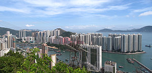
South Horizons (Chinese: 海怡半島) is a private housing estate located in Aberdeen at the western end of Ap Lei Chau (a.k.a. Aberdeen Island), in the Southern District of Hong Kong. Developed by Secan Limited, a Hutchison Whampoa associate company, it consists of 34 blocks, ranging in height from 25 to 42 storeys, completed between 1993 and 1995.

Lei Tung station
MTR station on Ap Lei Chau, Hong Kong
Distance: Approx. 828 meters
Latitude and longitude: 22.2421,114.1562
Lei Tung (Chinese: 利東; Cantonese Yale: Leihdūng) is an underground MTR rapid transit station in Hong Kong on the eastern section of the South Island line, located beside Mount Johnston on Ap Lei Chau in Southern District. The station is named after the adjacent public housing estate of the same name, which it serves in addition to Ap Lei Chau Main Street. The station is located below Yue On Court and Lei Tung Estate.

South Horizons station
MTR station on Ap Lei Chau, Hong Kong
Distance: Approx. 462 meters
Latitude and longitude: 22.2425,114.1491
South Horizons (Chinese: 海怡半島; Cantonese Yale: Hóiyì Bundóu) is an underground MTR rapid transit station in Hong Kong, located on Ap Lei Chau in Southern District. It is the southern terminus of the South Island line. The station is located under the junction of Yi Nam Road and South Horizon Drive, and primarily serves residents of the South Horizons private housing estate (its namesake), in addition to Ap Lei Chau Estate and Ap Lei Chau West Industrial Area.

Tin Wan
Distance: Approx. 534 meters
Latitude and longitude: 22.2514,114.1498
Tin Wan (Chinese: 田灣) is an area at the south of Hong Kong Island, Hong Kong. It is at the west of Aberdeen and the east of Kellett Bay and Wah Fu Estate.

Ap Lei Chau Estate
Public housing estate in Ap Lei Chau, Hong Kong
Distance: Approx. 211 meters
Latitude and longitude: 22.244705,114.1498625
Ap Lei Chau Estate (Chinese: 鴨脷洲邨) is a public housing estate in Ap Lei Chau, Hong Kong Island, Hong Kong. It is the first public housing estate in Ap Lei Chau. Completed in two phases in 1980 to 1982, respectively, the estate consists of 8 residential blocks providing 4,453 flats.

Aberdeen, Hong Kong
Area of Hong Kong
Distance: Approx. 233 meters
Latitude and longitude: 22.24777778,114.15166667
Aberdeen ( AB-ər-DEEN) is an area on southwest Hong Kong Island in Hong Kong. Administratively, it is part of the Southern District. While the name "Aberdeen" could be taken in a broad sense to encompass the areas of Aberdeen (town), Wong Chuk Hang, Ap Lei Chau, Tin Wan, Wah Kwai Estate and Wah Fu Estate, it is more often used to refer to the town only.

Aberdeen Typhoon Shelters
Typhoon shelters in Hong Kong
Distance: Approx. 406 meters
Latitude and longitude: 22.246025,114.153693
The Aberdeen Typhoon Shelters of Hong Kong are Aberdeen West Typhoon Shelter (Chinese: 香港仔西避風塘) and Aberdeen South Typhoon Shelter (香港仔南避風塘). Both typhoon shelters are located in Southern District, between the southern part of Hong Kong Island and the island Ap Lei Chau. They are roughly separated by the Ap Lei Chau Bridge and Aberdeen Channel Bridge.

Ap Lei Chau Power Station
Former power station in Hong Kong
Distance: Approx. 398 meters
Latitude and longitude: 22.243717,114.147521
The Ap Lei Chau Power Station was an oil-fired power station in Ap Lei Chau, Hong Kong.

Aberdeen Baptist Lui Ming Choi College
Distance: Approx. 773 meters
Latitude and longitude: 22.2422,114.1556
Aberdeen Baptist Lui Ming Choi College (abbreviated as ABLMCC, Chinese: 香港仔浸信會呂明才書院 or abbreviated as 浸中) is a Baptist co-educational government aided secondary school in Ap Lei Chau, Southern District, Hong Kong near Lei Tung station.
Weather in this IP's area
few clouds
25 Celsius
26 Celsius
23 Celsius
25 Celsius
1010 hPa
93 %
1010 hPa
1010 hPa
10000 meters
2.11 m/s
2.24 m/s
91 degree
18 %
06:35:47
17:40:27
