Country:
Region:
City:
Latitude and Longitude:
Time Zone:
Postal Code:
IP information under different IP Channel
ip-api
Country
Region
City
ASN
Time Zone
ISP
Blacklist
Proxy
Latitude
Longitude
Postal
Route
Luminati
Country
Region
cb
City
cabezondelasal
ASN
Time Zone
Europe/Madrid
ISP
Adamo Telecom Iberia S.A.
Latitude
Longitude
Postal
IPinfo
Country
Region
City
ASN
Time Zone
ISP
Blacklist
Proxy
Latitude
Longitude
Postal
Route
db-ip
Country
Region
City
ASN
Time Zone
ISP
Blacklist
Proxy
Latitude
Longitude
Postal
Route
ipdata
Country
Region
City
ASN
Time Zone
ISP
Blacklist
Proxy
Latitude
Longitude
Postal
Route
Popular places and events near this IP address

Llanes
Municipality in Asturias, Spain
Distance: Approx. 216 meters
Latitude and longitude: 43.42138889,-4.75638889
Llanes (the Concejo de Llanes, Conceyu de Llanes in Asturian language) is a municipality of the province of Asturias, in northern Spain. Stretching for about 30 km along the coast at the extreme east of the province, Llanes is bounded to the south by the high ridge of the limestone Sierra del Cuera, which rises to over 1,100 m. The region is part of the Costa Verde (Green Coast) of Spain, which is known for its spectacular coastal scenery, with 32 white sand beaches, and mountains covered with a deep green mantle.
Po, Asturias
Parish in Asturias, Spain
Distance: Approx. 2379 meters
Latitude and longitude: 43.42469,-4.78349
Po is a parish of the municipality of Llanes, Asturias, in the coast of northern Spain. The small town of Po is situated about 2 kilometers from the capital of the municipality. It has the shortest name in Spain.
CD Llanes
Association football club in Spain
Distance: Approx. 731 meters
Latitude and longitude: 43.420987,-4.763742
Club Deportivo Llanes is a football team based in Llanes in the autonomous community of Asturias. Founded in 1949, the team plays in Primera Asturfútbol. The club's home ground is San José, which has a capacity of 2,000 spectators.
Andrín
Parish in Asturias, Spain
Distance: Approx. 3794 meters
Latitude and longitude: 43.4,-4.716667
Andrín is one of 28 parishes (administrative divisions) in Llanes, a municipality within the province and autonomous community of Asturias, in northern Spain.
Barru (Llanes)
Parish in Asturias, Spain
Distance: Approx. 6311 meters
Latitude and longitude: 43.43361111,-4.83055556
Barru (Spanish: Barro) is one of 28 parishes (administrative divisions) in Llanes, a municipality within the province and autonomous community of Asturias, in northern Spain.

Celoriu
Parish in Asturias, Spain
Distance: Approx. 3949 meters
Latitude and longitude: 43.433333,-4.8
Celoriu is one of 28 parishes (administrative divisions) in Llanes, a municipality within the province and autonomous community of Asturias, in northern Spain.
Porrúa (Llanes)
Parish in Asturias, Spain
Distance: Approx. 3667 meters
Latitude and longitude: 43.416667,-4.8
Porrúa is one of 28 parishes (administrative divisions) in Llanes, a municipality within the province and autonomous community of Asturias, in northern Spain.

Vidiago
Parish in Asturias, Spain
Distance: Approx. 7464 meters
Latitude and longitude: 43.4,-4.666667
Vidiago is one of 28 parishes (administrative divisions) in Llanes, a municipality within the province and autonomous community of Asturias, in northern Spain.

Iglesia de Santa María del Conceyu (Llanes)
Church in Asturias, Spain
Distance: Approx. 193 meters
Latitude and longitude: 43.42138889,-4.75388889
Iglesia de Santa María del Conceyu (Llanes) is a church in Llanes, Asturias, Spain.

Sierra de Cuera
Distance: Approx. 7414 meters
Latitude and longitude: 43.35410278,-4.76988333
Sierra de Cuera (Asturian: Sierra del Cuera), is a 30 km long mountain chain of the Cantabrian Mountains. The ridge's highest point is Pico Turbina (1315 m). This mountain range is located at 6 km from the sea and runs parallel to the coast.

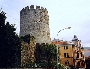
Tower of Llanes
Historic site in Llanes, Spain
Distance: Approx. 164 meters
Latitude and longitude: 43.42127,-4.754983
The Tower of Llanes (Spanish: Torreón de Llanes) is a medieval tower located in Llanes, Spain.

San Roque l'Acebal
Parish in Asturias, Spain
Distance: Approx. 3488 meters
Latitude and longitude: 43.39615,-4.72656
San Roque l'Acebal is a parish in Llanes municipality, in eastern Asturias, Spain. It is located in the central area of the conceyu (municipality), and is surrounded by the parishes of Cue (to the north), Purón (to the south), Andrín (to the east) and Llanes (to the west). Its territory, trapezoidal in shape and flat orography, has an extension of 4.06 km2.
Weather in this IP's area
scattered clouds
14 Celsius
13 Celsius
14 Celsius
14 Celsius
1019 hPa
75 %
1019 hPa
1018 hPa
10000 meters
2.34 m/s
3.1 m/s
125 degree
34 %
08:12:58
17:54:36