Country:
 Turkey
Region:
City:
Latitude and Longitude:
Time Zone:
Postal Code:
IP information under different IP Channel
ip-api
Country
Region
City
ASN
Time Zone
ISP
Blacklist
Proxy
Latitude
Longitude
Postal
Route
IPinfo
Country
Region
City
ASN
Time Zone
ISP
Blacklist
Proxy
Latitude
Longitude
Postal
Route
MaxMind
Country
Region
City
ASN
Time Zone
ISP
Blacklist
Proxy
Latitude
Longitude
Postal
Route
Luminati
Country
 UA
UAASN
Time Zone
Europe/Kyiv
ISP
PENTECH BILISIM TEKNOLOJILERI SANAYI VE TICARET LIMITED SIRKETi
Latitude
Longitude
Postal
db-ip
Country
Region
City
ASN
Time Zone
ISP
Blacklist
Proxy
Latitude
Longitude
Postal
Route
ipdata
Country
Region
City
ASN
Time Zone
ISP
Blacklist
Proxy
Latitude
Longitude
Postal
Route
Popular places and events near this IP address

Adapazarı
District and municipality in Sakarya, Turkey
Distance: Approx. 800 meters
Latitude and longitude: 40.78333333,30.4
Adapazarı (pronounced [ɑˈdɑpɑzɑɾɯ]) is a municipality and the capital district of Sakarya Province, Turkey. Its area is 324 km2, and its population is 281,489 (2022). It covers the central and northern part of the agglomeration of Adapazarı and the adjacent countryside.
Sakarya Atatürk Stadium
Distance: Approx. 2106 meters
Latitude and longitude: 40.77701389,30.38655833
Sakarya Atatürk Stadium (Turkish: Sakarya Atatürk Stadı) was a multi-purpose stadium in Adapazarı, Turkey. It was currently used mostly for football matches and was the home stadium of Sakaryaspor. The stadium used to hold 13,216 spectators.
Adapazarı ENKA School
Private school in Adapazarı, Turkey
Distance: Approx. 4522 meters
Latitude and longitude: 40.829,30.3974
After the earthquake on August 17, 1999, ENKA foundation joined Turkey's collective effort to provide relief to victims by building schools. In the province of Adapazarı, which suffered the worst damage in the tremor, a public day school for children in temporary accommodation and a private school for those who had lost their parents in the earthquake were planned, built and opened. Construction began in the first week of September 1999.

Sangarius Bridge
Late Roman (562) bridge in Turkey
Distance: Approx. 6375 meters
Latitude and longitude: 40.737428,30.372853
The Sangarius Bridge or Bridge of Justinian (Turkish: Justinianos Köprüsü or Beşköprü) is a late Roman bridge over the river Sakarya (Latin: Sangarius, Greek Σαγγάριος) in Anatolia, in modern-day Turkey. It was built by the East Roman Emperor Justinian I (527–565 AD) to improve communications between the capital Constantinople and the eastern provinces of his empire. With a remarkable length of 430 m, the bridge was mentioned by several contemporary writers, and has been associated with a supposed project, first proposed by Pliny the Younger to Emperor Trajan, to construct a navigable canal that would bypass the Bosporus.

Mithatpaşa railway station
Distance: Approx. 3996 meters
Latitude and longitude: 40.75888889,30.38
Mithatpaşa station is a railway station in Adapazarı, Turkey. It is serviced by the Ada Express to Istanbul and Adaray commuter trains to Adapazarı and Arifiye, although the later has been indefinitely suspended. The station also serves the TÜVASAŞ factory located adjacent to it.

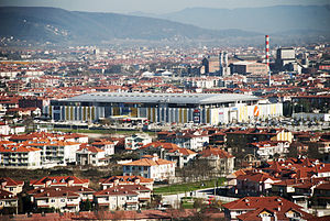
New Sakarya Atatürk Stadium
Distance: Approx. 2397 meters
Latitude and longitude: 40.78055556,30.43222222
New Sakarya Stadium, officially Sakarya Atatürk Stadyumu, is a stadium in Adapazarı, Sakarya, Turkey. It was opened to public in 2017 with a capacity of 28,113 spectators. It is the new home of Sakaryaspor of the TFF Second League.

Sakarya Sports Hall
Distance: Approx. 3182 meters
Latitude and longitude: 40.78694444,30.36833333
Sakarya Sports Hall (Turkish: Sakarya Spor Salonu) is a multi-purpose indoor arena located at Yazlık neighborhood of Serdivan district in Adapazarı, Sakarya Province, Turkey. The venue is used for competitions and trainings of a wide variety of sports branches including basketball, volleyball, handball, fencing, table tennis, wrestling, judo, karate, kick boxing and taekwondo. The sports hall was built in a land covering 21,000 m2 (5.2 acres), which was granted to the Youth and Sports Directorate of Sakarya Province by the Serdivan municipality on 1 September 2010.

Erenler, Sakarya
District and municipality in Sakarya, Turkey
Distance: Approx. 4423 meters
Latitude and longitude: 40.75,30.41666667
Erenler is a municipality and district of Sakarya Province, Turkey. Its area is 136 km2, and its population is 92,249 (2022). It covers the southeastern part of the agglomeration of Adapazarı and the adjacent countryside.

Sakarya Museum
Distance: Approx. 1710 meters
Latitude and longitude: 40.77388889,30.40166667
Sakarya Museum (a.k.a. Adapazarı Museum Turkish: Sakarya Müzesi) is a museum in Adapazarı, Turkey. It is on Milli Egemenlik Street.
Serdivan
District and municipality in Sakarya, Turkey
Distance: Approx. 5408 meters
Latitude and longitude: 40.76027778,30.35416667
Serdivan is a municipality and district of Sakarya Province, Turkey. Its area is 130 km2, and its population is 162,699 (2022). It covers the western part of the agglomeration of Adapazarı and the adjacent countryside.
32 Evler railway station
Distance: Approx. 4977 meters
Latitude and longitude: 40.75015,30.37655
32 Evler station (Turkish: 32 Evler istasyonu) is a station in Adapazarı, Turkey. It is serviced by Adaray commuter trains operating between Arifiye and Adapazarı. 32 Evler station was opened on 28 May 2013 along with the opening of the Adaray line and is one four new stations built on the 8.4 km (5.2 mi) railway to Adapazarı.
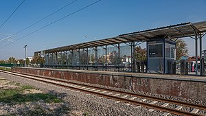
Kentparkı railway station
Distance: Approx. 2369 meters
Latitude and longitude: 40.77092,30.39097
Kentparkı station (Turkish: Kentparkı istasyonu) is a station in Adapazarı, Turkey. It is serviced by Adaray commuter trains operating between Arifiye and Adapazarı. Kentparkı station was opened on 28 May 2013 along with the opening of the Adaray line and is one four new stations built on the 8.4 km (5.2 mi) railway to Adapazarı.
Weather in this IP's area
overcast clouds
21 Celsius
20 Celsius
21 Celsius
21 Celsius
1010 hPa
42 %
1010 hPa
1007 hPa
10000 meters
0.78 m/s
2.32 m/s
283 degree
86 %
07:04:14
18:26:04