Country:
Region:
City:
Latitude and Longitude:
Time Zone:
Postal Code:
IP information under different IP Channel
ip-api
Country
Region
City
ASN
Time Zone
ISP
Blacklist
Proxy
Latitude
Longitude
Postal
Route
Luminati
Country
ASN
Time Zone
Europe/Warsaw
ISP
ITH sp. z o.o.
Latitude
Longitude
Postal
IPinfo
Country
Region
City
ASN
Time Zone
ISP
Blacklist
Proxy
Latitude
Longitude
Postal
Route
db-ip
Country
Region
City
ASN
Time Zone
ISP
Blacklist
Proxy
Latitude
Longitude
Postal
Route
ipdata
Country
Region
City
ASN
Time Zone
ISP
Blacklist
Proxy
Latitude
Longitude
Postal
Route
Popular places and events near this IP address

Świętokrzyska metro station
Warsaw metro station
Distance: Approx. 151 meters
Latitude and longitude: 52.23583333,21.0075
Świętokrzyska (Polish pronunciation: [ɕfjɛntɔˈkʂɨska]) is a transfer station on Lines M1 and M2 of the Warsaw Metro, located under the crossing of Świętokrzyska and Marszałkowska streets in the borough of Śródmieście. The station on M1 was opened on 11 May 2001 as part of the extension of M1 north from Centrum to Ratusz. Świętokrzyska has a non-revenue track that connects Lines M1 and M2 in order for M2 rolling stock to access Kabaty depot on M1 while the new Karolin depot on M2 is being built, and is the only interchange station between M1 and M2 metro lines.

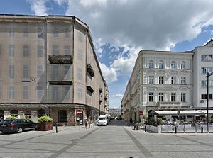
Zielna Street, Warsaw
Distance: Approx. 52 meters
Latitude and longitude: 52.236678,21.006381
Zielna (literally "related to weeds or herbs", "herbal") is a street in Warsaw city centre, Poland. Initially one of the main streets linking the southern city centre with its northern part, it lost much of its significance in 1941, when the nearby Marszałkowska street had been extended across the Saxon Garden to the Bankowy Sq. During the Warsaw Uprising of 1944 heavy fighting took place for the PAST skyscraper located at Zielna 37.

Jewish Theatre, Warsaw
Distance: Approx. 336 meters
Latitude and longitude: 52.23583333,21.00222222
The Ester Rachel and Ida Kaminska Jewish Theater (Polish: Teatr Żydowski im. Estery Racheli i Idy Kamińskich) is a state theatrical institution in Warsaw, Poland. It was named after the Polish-Jewish actress Ester Rachel Kamińska, who was called the "mother of Yiddish theater," and her daughter, the Academy Award-nominated actress Ida Kamińska.

Świętokrzyska Street, Warsaw
Street in Warsaw
Distance: Approx. 276 meters
Latitude and longitude: 52.23527778,21.00944444
Ulica Świętokrzyska (Holy Cross Street) in Warsaw's city centre is one of the Polish city's principal thoroughfares. It links the city's centre with Wola borough. The street is named for Holy Cross Church, which stands on Krakowskie Przedmieście.

Próżna Street, Warsaw
Distance: Approx. 111 meters
Latitude and longitude: 52.2365,21.0054
Ulica Próżna (lit. Vain Street) is a historical street in the Śródmieście Północne neighbourhood of the borough of Śródmieście in Warsaw, Poland. It is the only former Warsaw Ghetto street still featuring as many as four tenement houses.

Grzybów Square
Square in Warsaw
Distance: Approx. 257 meters
Latitude and longitude: 52.23609167,21.00331389
Grzybów Square (Polish: Plac Grzybowski, pronounced [ˈplat͡s ɡʐɘˈbɔf.ski]) is a triangular square in the Śródmieście (downtown) district of Warsaw, Poland, between Twarda, Bagno, Grzybowska and Królewska Streets.

All Saints Church, Warsaw
Church in Warsaw, Poland
Distance: Approx. 315 meters
Latitude and longitude: 52.235,21.003611
All Saints Church is a Roman Catholic church located at 3/5 Grzybowski Square in Warsaw, the seat of the parish of All Saints in Warsaw.

Janasz Palace
Historic site in Mazowsze Province, Poland
Distance: Approx. 79 meters
Latitude and longitude: 52.23722222,21.00555556
The Janasz Palace (Polish: Pałac Janaszów, Pałac Janaszów Czackich) is a historic building on ulica Zielna in Warsaw, Poland. It was built in 1870–80 for Jakub Janasz to a design by Jan Kacper Heurich. It suffered little in World War II and is the best preserved palace in Warsaw from the second half of the nineteenth century.

Holy Cross Park
An urban park in Warsaw, Poland
Distance: Approx. 308 meters
Latitude and longitude: 52.23433889,21.00646
The Holy Cross Park (Polish: Park Świętokrzyski) is an urban park in Warsaw, Poland. It is located in the district of Downtown, between Plater Street, Świętokrzyska Street, Marszałkowska Street, and the Palace of Culture and Science. The park was opened in 1955.

Żelazna Brama (neighbourhood)
Municipal neighbourhood in Warsaw, Masovian Voivodeship, Poland
Distance: Approx. 344 meters
Latitude and longitude: 52.23694444,21.00166667
Żelazna Brama, also designated as the Neighbourhood No. 3, is a municipal neighbourhood of the city of Warsaw, Poland, located within the district of Śródmieście, and administered by a neighbourhood council. It is located within the City Information System area of Śródmieście Północne.

Central Point (Warsaw)
A skyscraper in Warsaw, Poland
Distance: Approx. 195 meters
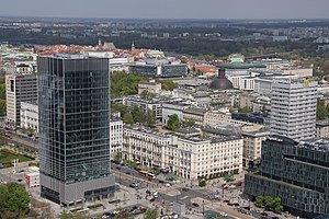
Latitude and longitude: 52.23541667,21.00747222
The Central Point, also known as the CBD One, is a skyscraper office building in Warsaw, Poland, located in the district of Downtown, at 37 Zielna Street, at the crossing of Marszałkowska Street and Świętokrzyska Street. The building was opened in 2021.

Centrum Królewska
An office building in Warsaw, Poland
Distance: Approx. 120 meters
Latitude and longitude: 52.23805556,21.0075
The Centrum Królewska is an office building in Warsaw, Poland, located at 142 Marszałkowska Street, at the crossing with Królewska Street. It was opened in 2002.
Weather in this IP's area
overcast clouds
2 Celsius
-2 Celsius
1 Celsius
3 Celsius
1032 hPa
91 %
1032 hPa
1018 hPa
9000 meters
4.92 m/s
140 degree
100 %
06:48:18
15:51:39