Country:
 USA
USARegion:
City:
Latitude and Longitude:
Time Zone:
Postal Code:
IP information under different IP Channel
ip-api
Country
Region
City
ASN
Time Zone
ISP
Blacklist
Proxy
Latitude
Longitude
Postal
Route
IPinfo
Country
Region
City
ASN
Time Zone
ISP
Blacklist
Proxy
Latitude
Longitude
Postal
Route
MaxMind
Country
Region
City
ASN
Time Zone
ISP
Blacklist
Proxy
Latitude
Longitude
Postal
Route
Luminati
Country
 LT
LTASN
Time Zone
Europe/Vilnius
ISP
Hostline, Uab
Latitude
Longitude
Postal
db-ip
Country
Region
City
ASN
Time Zone
ISP
Blacklist
Proxy
Latitude
Longitude
Postal
Route
ipdata
Country
Region
City
ASN
Time Zone
ISP
Blacklist
Proxy
Latitude
Longitude
Postal
Route
Popular places and events near this IP address

Newark, New Jersey
Most populous city in New Jersey, United States
Distance: Approx. 170 meters
Latitude and longitude: 40.73555556,-74.17222222
Newark ( NEW-ərk, locally: [nʊɹk]) is the most populous city in the U.S. state of New Jersey, the county seat of Essex County, and a principal city of the New York metropolitan area. As of the 2020 census, the city's population was 311,549. The Population Estimates Program calculated a population of 304,960 for 2023, making it the 66th-most populous municipality in the nation.

Downtown Newark
Central business district in United States
Distance: Approx. 145 meters
Latitude and longitude: 40.73611111,-74.17194444
Downtown Newark is the central business district of Newark in Essex County, in the U.S. state of New Jersey. Downtown is the site of the original Puritan settlement of Newark located at a bend in the Passaic River. The first settlers, led by Robert Treat, landed not far from the present site of the New Jersey Performing Arts Center.

Cedar Street subway
Distance: Approx. 213 meters
Latitude and longitude: 40.73871,-74.173224
The Cedar Street subway is a rail tunnel in Newark that allowed street cars (and later buses) access to the subterranean level of the Newark Public Service Terminal. It was built by the Public Service Corporation in 1916, as part of the terminal building, to reduce streetcar congestion at nearby Broad and Market streets, and provided access for a number of surface lines. The tunnel starts at street level at Washington Street and extends two blocks under Cedar Street and across Broad Street.

Newark Public Schools
School district in Essex County, New Jersey, US
Distance: Approx. 232 meters
Latitude and longitude: 40.737868,-74.171044
Newark Board of Education is a comprehensive community public school district that serves students in pre-kindergarten through twelfth grade in the city of Newark in Essex County, in the U.S. state of New Jersey. The state took over the district in 1995—the third takeover statewide—and returned control in 2018, after 22 years. The district is one of 31 former Abbott districts statewide that were established pursuant to the decision by the New Jersey Supreme Court in Abbott v.

Military Park station
Distance: Approx. 199 meters
Latitude and longitude: 40.73722222,-74.17111111
Military Park station (formerly Broad Street station) is an underground station on the Newark City Subway Line of the Newark Light Rail. The station is owned and service is operated by New Jersey Transit. The station is located at the intersection of Raymond Boulevard, Park Place and Broad Street in Downtown Newark at Military Park.

Washington Street station (Newark Light Rail)
Distance: Approx. 183 meters
Latitude and longitude: 40.73833333,-74.17416667
Washington Street station is an underground station on the Newark City Subway Line of the Newark Light Rail. The station is owned and service is operated by New Jersey Transit. The station is located at the intersection of Raymond Boulevard and Washington Street with a second entrance at University Avenue, both in Downtown Newark.

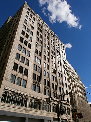
National Newark Building
Skyscraper in Newark, New Jersey, US
Distance: Approx. 200 meters
Latitude and longitude: 40.736653,-74.171032
The National Newark Building (Formerly the National Newark and Essex Bank Building) is a neo-classical office skyscraper in Newark, New Jersey. It has been the tallest building in Newark since 1931 and was tallest in New Jersey until 1989. At thirty-five stories, it has a height of 466 ft (142 m).

CWOW Gallery
Distance: Approx. 195 meters
Latitude and longitude: 40.737,-74.1757
cWOW Gallery, also known as City Without Walls Gallery, is a defunct alternative art gallery located in Newark, New Jersey, occupying a building on Halsey Street at Crawford Street in the Lincoln Park/The Coast Cultural District. City Without Walls was New Jersey's oldest not-for-profit alternative art space, in continuous operation since 1975 with a "two-fold mission offers career development opportunities to new and emerging artists, while providing the public a chance to understand and enjoy challenging contemporary art." The alternative art space relied on members to curate their on-site and off-site gallery spaces, cWOW, which stands for City Without Walls, had an estimated 6-10 exhibitions per year. It also ran three educational programs called City Murals, Newark New Media, and ArtReach.

First National State Bank Building
United States historic place
Distance: Approx. 252 meters
Latitude and longitude: 40.73472222,-74.17222222
The First National State Bank Building, also known as the Indigo Residence, is located at 810 Broad Street in Newark, Essex County, New Jersey, United States. The building was designed by Cass Gilbert and was built in 1912. The building stands 165 ft (50 m) and is twelve stories tall with a steel frame and with a facade of applied masonry.

Four Corners (Newark)
Historic district in Essex County, New Jersey, US
Distance: Approx. 173 meters
Latitude and longitude: 40.73556,-74.172172
The Four Corners Historic District is the intersection of Broad and Market Streets in Newark, New Jersey. It is the site of the city's earliest settlement and the heart of Downtown Newark that at one time was considered the busiest intersection in the United States. The area that radiates twenty-two square blocks from the crossroads is a state and federal historic district.
165 Halsey Street
Building in Newark, New Jersey
Distance: Approx. 38 meters
Latitude and longitude: 40.736817,-74.173851
165 Halsey Street, formerly known as the Bamberger Building, is a 14-story, office tower in Downtown Newark, New Jersey. Built in 1912–1929, it was designed by Jarvis Hunt. The building spans the entire block between Halsey Street, Market Street, Washington Street, and Bank Street.
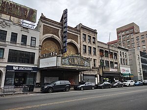
Newark Paramount Theatre
Vaudeville house and movie theater in Newark, New Jersey
Distance: Approx. 245 meters
Latitude and longitude: 40.73555,-74.17101
The Newark Paramount Theatre is an abandoned vaudeville house turned "movie palace" film theatre in the Four Corners Historic District in Downtown Newark, New Jersey.
Weather in this IP's area
few clouds
10 Celsius
9 Celsius
7 Celsius
13 Celsius
1033 hPa
66 %
1033 hPa
1033 hPa
10000 meters
4.12 m/s
20 degree
20 %
07:12:34
18:10:13