Country:
 Germany
Region:
City:
Latitude and Longitude:
Time Zone:
Postal Code:
IP information under different IP Channel
ip-api
Country
Region
City
ASN
Time Zone
ISP
Blacklist
Proxy
Latitude
Longitude
Postal
Route
IPinfo
Country
Region
City
ASN
Time Zone
ISP
Blacklist
Proxy
Latitude
Longitude
Postal
Route
MaxMind
Country
Region
City
ASN
Time Zone
ISP
Blacklist
Proxy
Latitude
Longitude
Postal
Route
Luminati
Country
DERegion
he
City
morlenbach
ASN
Time Zone
Europe/Berlin
ISP
ENTEGA Medianet GmbH
Latitude
Longitude
Postal
db-ip
Country
Region
City
ASN
Time Zone
ISP
Blacklist
Proxy
Latitude
Longitude
Postal
Route
ipdata
Country
Region
City
ASN
Time Zone
ISP
Blacklist
Proxy
Latitude
Longitude
Postal
Route
Popular places and events near this IP address

Wachenburg
Distance: Approx. 6713 meters
Latitude and longitude: 49.54944444,8.68555556
The Wachenburg (German: [ˈvaxn̩bʊʁk] ) is a castle on a hill overlooking Weinheim an der Bergstrasse, in Baden-Württemberg, Germany. It was built between 1907 and 1928 by the Weinheimer Senioren-Convent, a Corps of former students. The castle contains a restaurant with a nice view of the country.

Birkenau (Odenwald)
Municipality in Hesse, Germany
Distance: Approx. 4643 meters
Latitude and longitude: 49.5625,8.70694444
Birkenau in the Odenwald is a municipality in the Bergstraße district in southern Hesse, Germany. Its nickname is Das Dorf der Sonnenuhren – “The Sundial Village”.

Hemsbach
Town in Baden-Württemberg, Germany
Distance: Approx. 6144 meters
Latitude and longitude: 49.59027778,8.65638889
Hemsbach (German pronunciation: [ˈhɛmsˌbax] ) is a town with approximately 12,000 inhabitants in the Rhein-Neckar-Kreis of Baden-Württemberg, Germany. It belongs to the European Rhine-Neckar Metropolitan Region (Lower Neckar region until 20 May 2003 and Rhine-Neckar-Odenwald region until 31 December 2005). It is situated on the Bergstraße, 18 km northeast of Mannheim.

Fürth, Hesse
Municipality in Hesse, Germany
Distance: Approx. 6554 meters
Latitude and longitude: 49.65,8.78333333
Fürth is a municipality and a state-recognized recreational resort (Erholungsort) in the Bergstraße district in Hesse, Germany.

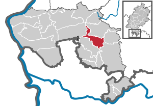
Mörlenbach
Municipality in Hesse, Germany
Distance: Approx. 450 meters
Latitude and longitude: 49.59916667,8.73472222
Mörlenbach is a municipality in the Bergstraße district in southern Hesse, Germany.

Laudenbach (Rhein-Neckar)
Municipality in Baden-Württemberg, Germany
Distance: Approx. 6711 meters
Latitude and longitude: 49.61138889,8.65
Laudenbach is a town in the district of Rhein-Neckar in Baden-Württemberg in Germany.
Rimbach, Hesse
Municipality in Hesse, Germany
Distance: Approx. 3145 meters
Latitude and longitude: 49.62333333,8.76
Rimbach (Ben-Stadt) in the Odenwald is a municipality in the Bergstraße district in southern Hesse, Germany.
Überwald
Distance: Approx. 5716 meters
Latitude and longitude: 49.5833,8.8166
The Überwald is a wooded area in the southeast of Bergstraße district in Hesse, Germany, between the "Anterior" and "Hinder" Odenwald, comprising the communities of Abtsteinach, Grasellenbach and Wald-Michelbach. Wald-Michelbach is the Überwald's central community. The name was likely first used by the inhabitants of the neighbouring Weschnitz valley.
Götzenstein
Distance: Approx. 6166 meters
Latitude and longitude: 49.55,8.78333333
The Götzenstein is a hill in the Odenwald range in Hesse, Germany.
Ober-Laudenbach
Distance: Approx. 5731 meters
Latitude and longitude: 49.61666667,8.66666667
Ober-Laudenbach is a district of the town of Heppenheim in the state of Hesse, Germany. Formerly an independent municipality, it was merged into Heppenheim in 1971.
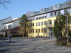
Martin-Luther-Schule
Grammar school in Rimbach, Hessen, Germany
Distance: Approx. 3046 meters
Latitude and longitude: 49.62333333,8.75666667
The Martin-Luther-Schule (MLS) is a secondary school ("Gymnasium") with the main focus on the subject of music. It is located in Rimbach, is a village in the "Weschnitztal" in Germany. With approximately 1,600 students, the MLS is one of the biggest schools in the "Kreis Bergstraße".
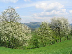
Tromm (Odenwald)
Mountain in Germany
Distance: Approx. 4536 meters
Latitude and longitude: 49.60444444,8.80277778
Tromm is an Odenwald mountain in Hesse, Germany.
Weather in this IP's area
overcast clouds
20 Celsius
20 Celsius
18 Celsius
21 Celsius
1013 hPa
85 %
1013 hPa
992 hPa
10000 meters
2.78 m/s
6.2 m/s
246 degree
100 %
06:51:27
19:54:10