45.143.45.213 - IP Lookup: Free IP Address Lookup, Postal Code Lookup, IP Location Lookup, IP ASN, Public IP
Country:
Region:
City:
Location:
Time Zone:
Postal Code:
ISP:
ASN:
language:
User-Agent:
Proxy IP:
Blacklist:
IP information under different IP Channel
ip-api
Country
Region
City
ASN
Time Zone
ISP
Blacklist
Proxy
Latitude
Longitude
Postal
Route
db-ip
Country
Region
City
ASN
Time Zone
ISP
Blacklist
Proxy
Latitude
Longitude
Postal
Route
IPinfo
Country
Region
City
ASN
Time Zone
ISP
Blacklist
Proxy
Latitude
Longitude
Postal
Route
IP2Location
45.143.45.213Country
Region
oberosterreich
City
mattighofen
Time Zone
Europe/Vienna
ISP
Language
User-Agent
Latitude
Longitude
Postal
ipdata
Country
Region
City
ASN
Time Zone
ISP
Blacklist
Proxy
Latitude
Longitude
Postal
Route
Popular places and events near this IP address

Auerbach, Upper Austria
Municipality in Upper Austria, Austria
Distance: Approx. 5635 meters
Latitude and longitude: 48.065,13.10916667
Auerbach (German pronunciation: [ˈaʊɐbax] ) is a town in Upper Austria, Austria. Its length from north to south is 4.3 km and from east to west is 5 km; its area is 10.78 km2. In 2015, it had 565 inhabitants.
Braunau District
District in Upper Austria, Austria
Distance: Approx. 4076 meters
Latitude and longitude: 48.131,13.109
Bezirk Braunau is a district of the state of Upper Austria in Austria.

Helpfau-Uttendorf
Municipality in Upper Austria, Austria
Distance: Approx. 5897 meters
Latitude and longitude: 48.15555556,13.11805556
Helpfau-Uttendorf is a municipality in the district of Braunau am Inn in the Austrian state of Upper Austria.
Jeging
Municipality in Upper Austria, Austria
Distance: Approx. 6379 meters
Latitude and longitude: 48.05,13.15
Jeging is a municipality in the district of Braunau am Inn in the Austrian state of Upper Austria.
Lochen am See
Municipality in Upper Austria, Austria
Distance: Approx. 8582 meters
Latitude and longitude: 48.03333333,13.18333333
Lochen am See is a municipality in the district of Braunau in the Austrian state of Upper Austria.

Maria Schmolln
Municipality in Upper Austria, Austria
Distance: Approx. 5688 meters
Latitude and longitude: 48.13333333,13.21666667
Maria Schmolln is a municipality in the district of Braunau am Inn of the Austrian state of Upper Austria state. The community is mainly known as an important pilgrimage destination among rural Innviertel. The name comes from its location on the “Schmollner Berg”, literally small mountain.

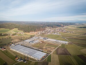
Mattighofen
Municipality in Upper Austria, Austria
Distance: Approx. 123 meters
Latitude and longitude: 48.10666667,13.14944444
Mattighofen is a town in the district of Braunau am Inn, part of the Innviertel region, in the Austrian state of Upper Austria.

Munderfing
Municipality in Upper Austria, Austria
Distance: Approx. 5130 meters
Latitude and longitude: 48.06666667,13.18333333
Munderfing is a municipality in the district of Braunau am Inn in the Austrian state of Upper Austria.

Pfaffstätt
Municipality in Upper Austria, Austria
Distance: Approx. 3627 meters
Latitude and longitude: 48.075,13.14444444
Pfaffstätt is a municipality in the district of Braunau am Inn in Austrian state of Upper Austria.
Pischelsdorf am Engelbach
Municipality in Upper Austria, Austria
Distance: Approx. 5643 meters
Latitude and longitude: 48.13055556,13.08333333
Pischelsdorf am Engelbach is a municipality in the district of Braunau am Inn in the Austrian state of Upper Austria.
St. Johann am Walde
Municipality in Upper Austria, Austria
Distance: Approx. 8675 meters
Latitude and longitude: 48.11666667,13.26666667
St. Johann am Walde is a municipality in the district of Braunau in the Austrian state of Upper Austria.
Schalchen
Municipality in Upper Austria, Austria
Distance: Approx. 1369 meters
Latitude and longitude: 48.11888889,13.15694444
Schalchen is a municipality in the district of Braunau am Inn in the Austrian state of Upper Austria.
Weather in this IP's area
few clouds
-0 Celsius
-3 Celsius
-0 Celsius
0 Celsius
1037 hPa
99 %
1037 hPa
977 hPa
10000 meters
2.25 m/s
4.33 m/s
88 degree
14 %


