Country:
Region:
City:
Latitude and Longitude:
Time Zone:
Postal Code:
IP information under different IP Channel
ip-api
Country
Region
City
ASN
Time Zone
ISP
Blacklist
Proxy
Latitude
Longitude
Postal
Route
Luminati
Country
ASN
Time Zone
Europe/Berlin
ISP
Netiface Limited
Latitude
Longitude
Postal
IPinfo
Country
Region
City
ASN
Time Zone
ISP
Blacklist
Proxy
Latitude
Longitude
Postal
Route
db-ip
Country
Region
City
ASN
Time Zone
ISP
Blacklist
Proxy
Latitude
Longitude
Postal
Route
ipdata
Country
Region
City
ASN
Time Zone
ISP
Blacklist
Proxy
Latitude
Longitude
Postal
Route
Popular places and events near this IP address

Islamabad
Capital city of Pakistan
Distance: Approx. 1767 meters
Latitude and longitude: 33.69305556,73.06388889
Islamabad (; Urdu: اسلامآباد, romanized: Islāmābād, ; transl. 'City of Islam') is the capital city of Pakistan. It is the country's ninth-most populous city with a population of 2,283,244 people and is federally administered by the Pakistani government as part of the Islamabad Capital Territory. Built as a planned city in the 1960s and established in 1967, it replaced Karachi as Pakistan's national capital.

Allama Iqbal Open University
Public university in Islamabad, Pakistan
Distance: Approx. 883 meters
Latitude and longitude: 33.68285319,73.05725157
Allama Iqbal Open University is a public university in Islamabad, Pakistan. It is named after Allama Muhammad Iqbal, the country's national poet. It is the world's fifth largest institution of higher learning in terms of enrolment, with an annual enrollment of 1,121,038 students (as of 2010), the majority are women and course enrollment of 3,305,948 (2011).
Higher Education Commission (Pakistan)
Statutory body formed by the Government of Pakistan
Distance: Approx. 1615 meters
Latitude and longitude: 33.67,73.05
The Higher Education Commission (colloquially known as HEC) is a statutory body formed by the Government of Pakistan which was established in 2002 under the Chairmanship of Atta-ur-Rahman. Its main functions are funding, overseeing, regulating and accrediting the higher education institutions in the country. It was first established in 1974 as University Grants Commission (UGC), and came into its modern form on 11 September 2002 after Atta-ur-Rahman's reforms, which received international praise.

Lok Virsa Museum
Museum in Islamabad, Pakistan
Distance: Approx. 1742 meters
Latitude and longitude: 33.68333333,73.06666667
Heritage Museum (Urdu: لوک ورثہ عجائب گھر), also known as Lok Virsa Museum, is a museum administered and managed by Lok Virsa - National Institute of Folk & Traditional Heritage. It is a museum of history and culture in Islamabad, Pakistan, located on the Shakarparian Hills showcasing the living cultures of Pakistan. The museum opened in 1974 and became an autonomous institute in 2002 following the Lok Virsa Legal Status Ordinance, 2002.
Pakistan Red Crescent Society
Humanitarian organization in Pakistan
Distance: Approx. 349 meters
Latitude and longitude: 33.68326336,73.05140992
Pakistan Red Crescent Society (Urdu: ہلالِ احمر پاکستان), is a national society of the Islamic Republic of Pakistan in the humanitarian sector, that provides emergency medical and relief services in Pakistan in both natural and human-made disasters. The organization was founded on 20 December 1947 after Pakistan's independence by an order called the Pakistan Red Cross Order (Succession to Indian Red Cross, established on June 7th 1920), issued by Muhammad Ali Jinnah, as Governor General of Pakistan. Jinnah became the founding president of the National Society.

Zero Point Interchange
Cloverleaf interchange in Islamabad, Pakistan
Distance: Approx. 1887 meters
Latitude and longitude: 33.69361111,73.065
Zero Point Interchange is a large cloverleaf interchange in Islamabad, Pakistan. It is located at the intersection of Islamabad Highway, Srinagar Highway, and Khayaban-e-Suharwardy. It was inaugurated in 5 July 2011, and has an estimated life of 30 years.

Pakistan Institute of Medical Sciences
Hospital and medical institute in Islamabad, Pakistan
Distance: Approx. 1747 meters
Latitude and longitude: 33.7,73.05
Pakistan Institute of Medical Sciences (Urdu: پاکستان دانش کدہ برائے طبّی سائنس, abbreviated as PIMS) is a research oriented health sciences institute located in Islamabad, Pakistan. It is one of the region's leading tertiary level hospitals which includes 22 medical and surgical specialist centers. It provides medical training through the Quaid-e-Azam Postgraduate Medical College which was established on 1 February 1989.

Federal Medical and Dental College
Medical and Dental college in Islamabad, Pakistan
Distance: Approx. 1623 meters
Latitude and longitude: 33.698,73.0542
The Federal Medical and Dental College (Urdu: وفاقی طبی اور دندان سازی کالج) (abbreviated as FMDC) is a medical school located in Islamabad, Pakistan. The college gives admission to 110 (including 10 goodwill seats for Afghanistan) Bachelor of Medicine and Bachelor of Surgery (MBBS) students each year. FMDC is a constituent college of Shaheed Zulfiqar Ali Bhutto Medical University.

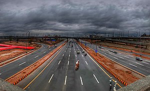
Peshawar Morr Interchange
Road junction
Distance: Approx. 35 meters
Latitude and longitude: 33.68453,73.04756
Peshawar Morr Interchange (also known as G-9 interchange) is Pakistan's biggest interchange in Islamabad, Pakistan. It is located at the intersection of Srinagar Highway and the Ninth Avenue, connecting the G and H sectors of Islamabad. Peshawar Morr interchange eased traffic congestion on two main highways of the capital city i.e.
Shifa Tameer-e-Millat University
Pakistani university
Distance: Approx. 1841 meters
Latitude and longitude: 33.67772542,73.06607987
Shifa Tameer-e-Millat University (STMU) is a private university, established in 2012 in Islamabad, Pakistan. It is set up as a nonprofit institution in the private sector.

H-8, Islamabad
Sector in Capital Territory, Pakistan
Distance: Approx. 1587 meters
Latitude and longitude: 33.6826,73.0649
H-8 (Urdu: حلقہ ایچ ۸) is a sector of Islamabad. The sector is bounded by Srinagar Highway and G-8 to the north, Islamabad Expressway and Shakarparian to the east, I-8 to the south, and Ninth Avenue and H-9 to the west. Similar to other H-sectors, H-8 is provided for education and health facilities.
National Seismic Monitoring Centre
Earthquake monitoring station in Islamabad, Pakistan
Distance: Approx. 1485 meters
Latitude and longitude: 33.68358611,73.06390278
National Seismic Monitoring Centre is a earthquake monitoring center in Islamabad, Pakistan. The center is managed by Pakistan Meteorological Department.
Weather in this IP's area
overcast clouds
25 Celsius
26 Celsius
25 Celsius
25 Celsius
1013 hPa
63 %
1013 hPa
954 hPa
10000 meters
1.68 m/s
1.93 m/s
253 degree
100 %
06:33:17
17:09:53