45.139.90.155 - IP Lookup: Free IP Address Lookup, Postal Code Lookup, IP Location Lookup, IP ASN, Public IP
Country:
Region:
City:
Location:
Time Zone:
Postal Code:
IP information under different IP Channel
ip-api
Country
Region
City
ASN
Time Zone
ISP
Blacklist
Proxy
Latitude
Longitude
Postal
Route
Luminati
Country
Region
32
City
holysov
ASN
Time Zone
Europe/Prague
ISP
United Networks SE
Latitude
Longitude
Postal
IPinfo
Country
Region
City
ASN
Time Zone
ISP
Blacklist
Proxy
Latitude
Longitude
Postal
Route
IP2Location
45.139.90.155Country
Region
plzensky kraj
City
pilsen
Time Zone
Europe/Prague
ISP
Language
User-Agent
Latitude
Longitude
Postal
db-ip
Country
Region
City
ASN
Time Zone
ISP
Blacklist
Proxy
Latitude
Longitude
Postal
Route
ipdata
Country
Region
City
ASN
Time Zone
ISP
Blacklist
Proxy
Latitude
Longitude
Postal
Route
Popular places and events near this IP address

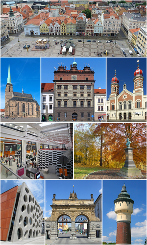
Plzeň
City in the Czech Republic
Distance: Approx. 52 meters
Latitude and longitude: 49.7475,13.3775
Plzeň (Czech pronunciation: [ˈpl̩zɛɲ] ), also known in English and German as Pilsen (German: [ˈpɪlzn̩] ), is a city in the Czech Republic. It is the fourth most populous city in the Czech Republic with about 186,000 inhabitants. It is located about 78 kilometres (48 miles) west of Prague, at the confluence of four rivers: Mže, Úhlava, Úslava and Radbuza, together forming the Berounka River.

Siege of Pilsen
1618 battle of the Thirty Years' War
Distance: Approx. 59 meters
Latitude and longitude: 49.7475,13.3776
The siege of Pilsen (or Plzeň) or Battle of Pilsen was a siege of the fortified city of Pilsen (Czech: Plzeň) in Bohemia carried out by the forces of the Bohemian Protestants led by Ernst von Mansfeld. It was the first major battle of the Thirty Years' War. The Protestant victory and subsequent capture of the city enlarged the Bohemian Revolt.
Great Synagogue (Plzeň)
Reform synagogue in Plzeň, Czech Republic
Distance: Approx. 307 meters
Latitude and longitude: 49.74666667,13.37277778
The Great Synagogue (Czech: Velká synagoga) is a Reform Jewish congregation and synagogue, located in Plzeň, in the Czech Republic. The synagogue is the second largest synagogue in Europe.
Pilsner Urquell Brewery
Czech beer brewery
Distance: Approx. 757 meters
Latitude and longitude: 49.74666667,13.38722222
Plzeňský Prazdroj, a. s. (pronounced [ˈpl̩zɛɲskiː ˈprazdroj a ˈɛs]; Pilsner Urquell Brewery) is a Czech brewery which opened in 1842 in Plzeň, Bohemia.

Doosan Arena
Stadium in Plzeň, Czech Republic
Distance: Approx. 684 meters
Latitude and longitude: 49.75,13.38555556
Doosan Arena, previously known as Stadion města Plzně (Plzeň City Stadium), is a multi-purpose stadium in Plzeň, Czech Republic. It is located in Štrunc Park, near the confluence of the Mže and Radbuza rivers. The stadium is currently used mostly for football matches and is the home ground of FC Viktoria Plzeň.

Cathedral of St. Bartholomew, Plzeň
Church in Plzeň, Czech Republic
Distance: Approx. 59 meters
Latitude and longitude: 49.7475,13.3776
The Cathedral of St. Bartholomew (Czech: Katedrála svatého Bartoloměje), originally the Church of St. Bartholomew, is a Gothic church located on the Main Square in Plzeň, Czech Republic.

Náměstí Republiky, Plzeň
Distance: Approx. 66 meters
Latitude and longitude: 49.74722222,13.3775
The Square of the Republic (in Czech Naměstí republiky) forms the historical centre of Plzeň, Czech Republic. With a size of 552 by 627 feet (168 m × 191 m) it is one of the largest medieval squares in the Czech lands. Plzeň as a town appears at the end of the 13th century, the square existing since then.
Pilsen Plaza
Shopping mall in Plzeň, Czech Republic
Distance: Approx. 566 meters
Latitude and longitude: 49.74948333,13.36949167
Pilsen Plaza (Czech: Plzeň Plaza) is a 20,000-square-metre (220,000-square-foot) shopping mall and entertainment center in Plzeň, Czech Republic.

J. K. Tyl Theatre
Distance: Approx. 347 meters
Latitude and longitude: 49.74541667,13.37336111
Josef Kajetán Tyl Theatre (Czech: Divadlo Josefa Kajetána Tyla) is a main theatre in Plzeň, Czech Republic. The theatre was built between 1899 and 1902 in the Neo-Renaissance style with some Art Nouveau elements to the design of Antonin Balsanek. Every year the theatre performs some 18 premieres of drama, operas, operettas, ballets or musicals.
New Theatre (Plzeň)
Distance: Approx. 499 meters
Latitude and longitude: 49.74839722,13.36996944
The New Theatre (Czech: Nové divadlo) in Plzeň is a Czech theatre. Construction of the venue cost 880 million CZK. The first performance at the New Theatre was The Bartered Bride from Bedřich Smetana.

Siege of Pilsen (1433–1434)
Distance: Approx. 217 meters
Latitude and longitude: 49.74666667,13.37944444
The siege of Pilsen lasted from 14 July 1433 to 9 May 1434 and was an important encounter of the Hussite Wars. Hussite troops led by Prokop the Great had unsuccessfully besieged the Catholic city of Pilsen for nine months and twenty three days. Failure to capture one of the last major Catholic cities in Bohemia along with the fall of New Town was a huge blow for the Hussite groups that foreshadowed their decisive defeat in the Battle of Lipany.
Franciscan Monastery, Plzeň
Distance: Approx. 288 meters
Latitude and longitude: 49.74536111,13.37880556
The Franciscan Monastery (Czech: Františkánský klášter) is located near the Main Square in Plzeň, Czech Republic. Originally belonging to the Minorites, the later Franciscan monastery was founded at the end of the 13th century. The Church of the Assumption of the Virgin Mary, Chapterhouse and Chapel of St.
Weather in this IP's area
mist
-2 Celsius
-2 Celsius
-4 Celsius
-0 Celsius
1039 hPa
96 %
1039 hPa
998 hPa
4500 meters
0.51 m/s
340 degree
7 %


