45.139.213.186 - IP Lookup: Free IP Address Lookup, Postal Code Lookup, IP Location Lookup, IP ASN, Public IP
Country:
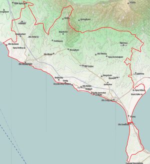
 Greece
Region:
City:
Location:
Time Zone:
Postal Code:
ISP:
ASN:
language:
User-Agent:
Proxy IP:
Blacklist:
IP information under different IP Channel
ip-api
Country
Region
City
ASN
Time Zone
ISP
Blacklist
Proxy
Latitude
Longitude
Postal
Route
db-ip
Country
Region
City
ASN
Time Zone
ISP
Blacklist
Proxy
Latitude
Longitude
Postal
Route
IPinfo
Country
Region
City
ASN
Time Zone
ISP
Blacklist
Proxy
Latitude
Longitude
Postal
Route
IP2Location
45.139.213.186Country
grRegion
kentriki makedonia
City
portaria
Time Zone
Europe/Athens
ISP
Language
User-Agent
Latitude
Longitude
Postal
ipdata
Country
Region
City
ASN
Time Zone
ISP
Blacklist
Proxy
Latitude
Longitude
Postal
Route
Popular places and events near this IP address

Olynthus
Ancient Greek city
Distance: Approx. 4798 meters
Latitude and longitude: 40.296,23.354
Olynthus (Ancient Greek: Ὄλυνθος Olynthos, named for the ὄλυνθος olunthos, "the fruit of the wild fig tree") is an ancient city in present-day Chalcidice, Greece. It was built mostly on two flat-topped hills 30–40m in height, in a fertile plain at the head of the Gulf of Torone, near the neck of the peninsula of Pallene, about 2.5 kilometers from the sea, and about 60 stadia (c. 9–10 kilometers) from Poteidaea.

Battle of Spartolos
Peloponnesian War battle, 429 BC between Athens and the Chalcidian League and their allies
Distance: Approx. 391 meters
Latitude and longitude: 40.2832,23.2954
The Battle of Spartolos took place in 429 BC between Athens and the Chalcidian League and their allies, in the early part of the Peloponnesian War. The fall of Potidaea had not succeeded in quelling the rebellion against Athens in Chalcidice. To ensure a steady stream of imperial revenue and suppress additional local uprisings, the Athenians dispatched Xenophon (son of Euripides) with 2,000 hoplites and 200 cavalry to launch an attack on Spartolos.

Nea Moudania
City in Macedonia, Greece
Distance: Approx. 5740 meters
Latitude and longitude: 40.23333333,23.28333333
Nea Moudania (Greek: Νέα Μουδανιά, Néa Moudaniá; often referred to as Moudania (Μουδανιά, Moudaniá), the name of the municipal unit to which the town belongs, is the seat of the municipality of Nea Propontida, Chalkidiki, Greece. The town is 60 km south of Thessaloniki and is the financial and commercial center of Chalkidiki, as well as its most populous town. It was built after 1922 by Greek refugees from Asia Minor who wanted to give the settlement the name of their hometown (now Mudanya, Turkey), hence the addition of the word nea, which means new in Greek.

Moudania (municipal unit)
Municipal unit in Greece
Distance: Approx. 5740 meters
Latitude and longitude: 40.23333333,23.28333333
Moudania (Greek: Μουδανιά, Moudaniá) is a former municipality in Chalkidiki, Greece, named after Mudanya in present Turkey. Since the 2011 local government reform it is part of the municipality Nea Propontida, of which it is a municipal unit. The municipal unit has an area of 141.464 km2.

Triglia
Municipal unit in Greece
Distance: Approx. 9267 meters
Latitude and longitude: 40.31666667,23.2
Triglia (Greek: Τρίγλια) is a former municipality in Chalkidiki, Greece. Since the 2011 local government reform it is part of the municipality Nea Propontida, of which it is a municipal unit. The municipal unit has an area of 121.959 km2.
Nea Propontida
Municipality in Greece
Distance: Approx. 5740 meters
Latitude and longitude: 40.23333333,23.28333333
Nea Propontida (Greek: Νέα Προποντίδα, "New Propontis") is a municipality in the Chalkidiki regional unit, Central Macedonia, Greece. The seat of the municipality is the town Nea Moudania. The municipality has an area of 372.317 km2.

Archaeological Museum of Olynthos
Museum in Greece
Distance: Approx. 4487 meters
Latitude and longitude: 40.29,23.3521
The Archaeological Museum of Olynthos opened in July 1998 in a building on the archaeological site of ancient Olynthos, 5 km from Moudania, Halkidiki in Central Macedonia, Greece. The excavational finds are in the Archaeological Museum of Polygyros. The Olynthos Museum has only audio-visual material, the purpose of which is to give visitors a picture of the archaeological site of Olynthos, starting with the history of the city and moving on to a description of the excavation and the restoration.

Kalyves Polygyrou
Settlement in Greece
Distance: Approx. 8492 meters
Latitude and longitude: 40.28333333,23.4
Kalyves Polygyrou or Kalives, (Greek: Καλύβες, [kaˈlives]), old name Mecyberna, is a village in Chalkidiki peninsula in Central Macedonia of Northern Greece. There is a kindergarten and primary school to accommodate pupils of both Kalyves and the nearby village of Yerakini. Patron Saint of the village is St.

Agios Mamas, Chalkidiki
Community in Greece
Distance: Approx. 5637 meters
Latitude and longitude: 40.25,23.35
Agios Mamas (Greek: ΄Αγιος Μάμας [ˈaʝios ˈmamas]) is a village in the Chalkidiki peninsula in northern Greece. It is in the municipal unit of Moudania, within the Municipality of Nea Propontida.

Mecyberna
Town of Chalcidice, ancient Macedonia
Distance: Approx. 8180 meters
Latitude and longitude: 40.278319,23.396101
Mecyberna or Mekyberna (Ancient Greek: Μηκύβερνα) was a town of Chalcidice, ancient Macedonia, which stood at the head of the Toronaic Gulf, which was also called Sinus Mecybernaeus. Mecyberna was the port of Olynthus. and lay between that town and Sermyle.
Pleume
Distance: Approx. 8304 meters
Latitude and longitude: 40.295137,23.20344
Pleume (Ancient Greek: Πλεύμε) was a town of the Chalcidice in ancient Macedonia. It belonged to the Delian League since it appears in the tribute records of Athens between 434/3 and 429/8 BCE, where it paid a phoros of 1000 drachmas, as well as in a tributary decree of 422/1 BCE. Its site is located in the northwestern part of the Chalcidice.
Sinus (Chalcidice)
Distance: Approx. 6518 meters
Latitude and longitude: 40.291278,23.223955
Sinus or Sinos (Ancient Greek: Σίνος) was a town of the Chalcidice in ancient Macedonia. It belonged to the Delian League since it appears in the tribute records of Athens of 434/3 and 433/2 BCE, where it paid a phoros of 1500 drachmas, and in those of 421/0 BCE where it paid 800 drachmas. It also appears in a tributary decree of 422/1 BCE. Its territory was probably the Sinea found in an inscription dated to 305-297 BCE. Its site is in northwestern Chalcidice.
Weather in this IP's area
overcast clouds
8 Celsius
6 Celsius
8 Celsius
9 Celsius
1031 hPa
55 %
1031 hPa
1023 hPa
10000 meters
5.39 m/s
4.9 m/s
114 degree
90 %