45.132.100.140 - IP Lookup: Free IP Address Lookup, Postal Code Lookup, IP Location Lookup, IP ASN, Public IP
Country:
Region:
City:
Location:
Time Zone:
Postal Code:
IP information under different IP Channel
ip-api
Country
Region
City
ASN
Time Zone
ISP
Blacklist
Proxy
Latitude
Longitude
Postal
Route
Luminati
Country
ASN
Time Zone
Europe/Budapest
ISP
Last-Mile Ltd.
Latitude
Longitude
Postal
IPinfo
Country
Region
City
ASN
Time Zone
ISP
Blacklist
Proxy
Latitude
Longitude
Postal
Route
IP2Location
45.132.100.140Country
Region
borsod-abauj-zemplen
City
malyi
Time Zone
Europe/Budapest
ISP
Language
User-Agent
Latitude
Longitude
Postal
db-ip
Country
Region
City
ASN
Time Zone
ISP
Blacklist
Proxy
Latitude
Longitude
Postal
Route
ipdata
Country
Region
City
ASN
Time Zone
ISP
Blacklist
Proxy
Latitude
Longitude
Postal
Route
Popular places and events near this IP address

Nyékládháza
Town in Borsod-Abaúj-Zemplén, Hungary
Distance: Approx. 2792 meters
Latitude and longitude: 47.99175,20.83706
Nyékládháza is a small town in Borsod-Abaúj-Zemplén county, northern Hungary, 20 kilometres (12 miles) from county capital Miskolc.
Battle of Mohi
1241 battle during the first Mongol invasion of Hungary
Distance: Approx. 7353 meters
Latitude and longitude: 47.97777778,20.91305556
The Battle of Muhi (11 April 1241) was a pivotal conflict between the Mongol Empire and the Kingdom of Hungary during the Mongol invasion of Europe. The battle took place at Muhi (then Mohi), a town located in present-day Hungary, southwest of the Sajó River. The Mongol Empire, led by Batu Khan, sought to expand its territories into Europe, while the Kingdom of Hungary, led by King Béla IV, aimed to protect its borders.

Kistokaj
Village in Northern Hungary, Hungary
Distance: Approx. 2854 meters
Latitude and longitude: 48.042,20.8395
Kistokaj is a village in Borsod-Abaúj-Zemplén county, Hungary.

Alsózsolca
Town in Borsod-Abaúj-Zemplén, Hungary
Distance: Approx. 6948 meters
Latitude and longitude: 48.07068,20.88018
Alsózsolca is a town in Borsod-Abaúj-Zemplén county, Hungary. In the 19th and 20th centuries, a Jewish community lived in the village. In 1930, there were 75 Jews in the village.

Bükkaranyos
Village in Northern Hungary, Hungary
Distance: Approx. 5246 meters
Latitude and longitude: 47.98549,20.78053
Bükkaranyos is a village in Borsod-Abaúj-Zemplén county, Hungary.

Hejőkeresztúr
Place in Borsod-Abaúj-Zemplén, Hungary
Distance: Approx. 6773 meters
Latitude and longitude: 47.96325,20.87672
Hejőkeresztúr is a village in Borsod-Abaúj-Zemplén county, Hungary.

Mályi
Village in Northern Hungary, Hungary
Distance: Approx. 4 meters
Latitude and longitude: 48.01666667,20.83333333
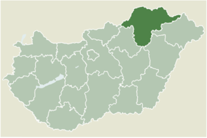
Mályi is a village in Borsod-Abaúj-Zemplén County in northeastern Hungary.
Ónod
Village in Northern Hungary, Hungary
Distance: Approx. 6481 meters
Latitude and longitude: 48,20.91666667
Ónod is a village in Borsod-Abaúj-Zemplén County in northeastern Hungary. There are around 2,000 people living there. Ónod has a long history reflected by some of the older buildings in the town, including the castle and the post carriage stopping point.

Sajópetri
Village in Northern Hungary, Hungary
Distance: Approx. 5300 meters
Latitude and longitude: 48.03333333,20.9
Sajópetri is a village in Borsod-Abaúj-Zemplén County in northeastern Hungary.

Sajólád
Village in Northern Hungary, Hungary
Distance: Approx. 5988 meters
Latitude and longitude: 48.04358,20.90297
Sajólád is a village in Borsod-Abaúj-Zemplén County in northeastern Hungary.
Lajos Kossuth Elementary School
Distance: Approx. 2733 meters
Latitude and longitude: 47.99222222,20.83611111
Lajos Kossuth Elementary School is an educational institute with eight grades located in Nyékládháza, Hungary. The principal is Miklós (Michael) Marján.

Szirma
Distance: Approx. 6037 meters
Latitude and longitude: 48.07083333,20.82833333
Szirma is a suburban area of the city of Southeast Miskolc, Hungary, with a population of 4235 (2008). Szirma once was a village and has been part of Miskolc since 1950. Nowadays it is a peaceful and a family-friendly area with easy access to city centre.
Weather in this IP's area
overcast clouds
9 Celsius
7 Celsius
8 Celsius
9 Celsius
1008 hPa
93 %
1008 hPa
996 hPa
10000 meters
3.16 m/s
8.77 m/s
212 degree
100 %
