45.13.190.47 - IP Lookup: Free IP Address Lookup, Postal Code Lookup, IP Location Lookup, IP ASN, Public IP
Country:
Region:
City:
Location:
Time Zone:
Postal Code:
IP information under different IP Channel
ip-api
Country
Region
City
ASN
Time Zone
ISP
Blacklist
Proxy
Latitude
Longitude
Postal
Route
Luminati
Country
ASN
Time Zone
Europe/Kyiv
ISP
PENTECH BILISIM TEKNOLOJILERI SANAYI VE TICARET LIMITED SIRKETi
Latitude
Longitude
Postal
IPinfo
Country
Region
City
ASN
Time Zone
ISP
Blacklist
Proxy
Latitude
Longitude
Postal
Route
IP2Location
45.13.190.47Country
Region
manisa
City
manisa
Time Zone
Europe/Istanbul
ISP
Language
User-Agent
Latitude
Longitude
Postal
db-ip
Country
Region
City
ASN
Time Zone
ISP
Blacklist
Proxy
Latitude
Longitude
Postal
Route
ipdata
Country
Region
City
ASN
Time Zone
ISP
Blacklist
Proxy
Latitude
Longitude
Postal
Route
Popular places and events near this IP address

Battle of Magnesia
190/89 BCE battle in which Rome and Pergamon defeated the Seleucids
Distance: Approx. 789 meters
Latitude and longitude: 38.6167,27.4333
The Battle of Magnesia took place in either December 190 or January 189 BC. It was fought as part of the Roman–Seleucid War, pitting forces of the Roman Republic led by the consul Lucius Cornelius Scipio Asiaticus and the allied Kingdom of Pergamon under Eumenes II against a Seleucid army of Antiochus III the Great. The two armies initially camped northeast of Magnesia ad Sipylum in Asia Minor (modern-day Manisa, Turkey), attempting to provoke each other into a battle on favorable terrain for several days. When the battle finally began, Eumenes managed to throw the Seleucid left flank into disarray.

Manisa
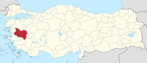
Metropolitan municipality in Manisa Province, Aegean Region, Turkey
Distance: Approx. 355 meters
Latitude and longitude: 38.61444444,27.42916667
Manisa (Turkish pronunciation: [maˈnisa]) is a city in Turkey's Aegean Region and the administrative seat of Manisa Province, lying approximately 40 km northeast of the major city of İzmir. The city forms the urban part of the districts Şehzadeler and Yunusemre, with a population of 385,452 in 2022. Modern Manisa is a booming center of industry and services, advantaged by its closeness to the international port city and the regional metropolitan center of İzmir and by its fertile hinterland rich in quantity and variety of agricultural production.
Magnesia ad Sipylum
Ancient Greek city in Asia Minor
Distance: Approx. 789 meters
Latitude and longitude: 38.61666667,27.43333333
Magnesia ad Sipylum (Greek: Mαγνησία ἡ πρὸς Σιπύλῳ or Mαγνησία ἡ ἐπὶ Σιπύλου; modern Manisa, Turkey) was a city of Lydia, situated about 65 km northeast of Smyrna (now İzmir) on the river Hermus (now Gediz) at the foot of Mount Sipylus. The city should not be confused with its older neighbor, Magnesia on the Maeander, both founded by colonists from the Greek region of Magnesia.

Manisa 19 Mayıs Stadium
Distance: Approx. 1691 meters
Latitude and longitude: 38.62300556,27.43993333
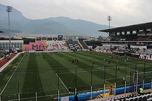
Manisa 19 Mayıs Stadium is a multi-purpose stadium in Manisa, Turkey. It is currently used mostly for football matches and is the home ground of TFF First League team Manisa FK. The stadium is named after the date 19 May 1919 when Mustafa Kemal Atatürk set foot on land in Samsun to start the Turkish national independence movement. With the promotion of Manisaspor to the Turkish Süper Lig at the end of the 2008–09 season, the stadium underwent renovation, boosting the capacity from 14,280 to 16,597.

Manisa Celal Bayar University
Public university in Manisa, Turkey
Distance: Approx. 3900 meters
Latitude and longitude: 38.610633,27.381599
Manisa Celal Bayar University or (CBU) is a public research university located in Manisa, Turkey. CBU traces its root back to 1959 as an independent sports and teachers' college in Manisa. The main campus is in Muradiye district of Manisa.

Sultan Mosque, Manisa
Distance: Approx. 181 meters
Latitude and longitude: 38.61063889,27.42730556
Sultan Mosque also called Hafsa Sultan Mosque is a 16th-century Ottoman mosque in Manisa, Turkey.

Manisa (electoral district)
Electoral district for the Grand National Assembly of Turkey
Distance: Approx. 291 meters
Latitude and longitude: 38.6098,27.428
Manisa is an electoral district of the Grand National Assembly of Turkey. It elects ten members of parliament (deputies) to represent the province of the same name for a five-year term by the D'Hondt method, a party-list proportional representation system.

Yunusemre
District and municipality in Manisa, Turkey
Distance: Approx. 988 meters
Latitude and longitude: 38.61666667,27.41666667
Yunusemre is a municipality and district of Manisa Province, Turkey. Its area is 823 km2, and its population is 266,514 (2022). It covers the western part of the agglomeration of Manisa and the adjacent countryside.

Şehzadeler
District and municipality in Manisa, Turkey
Distance: Approx. 1173 meters
Latitude and longitude: 38.6166,27.4386
Şehzadeler is a municipality and district of Manisa Province, Turkey. Its area is 515 km2, and its population is 167,227 (2022). It covers the eastern part of the agglomeration of Manisa and the adjacent countryside.

Muradiye Mosque, Manisa
Mosque in Manisa, Turkey
Distance: Approx. 333 meters
Latitude and longitude: 38.60988889,27.42897222
The Muradiye Mosque (Turkish: Muradiye Camii) is a 16th-century Ottoman mosque in the town of Manisa in southwest Turkey. It was commissioned by the sultan Murad III and designed by the imperial architect Mimar Sinan.

Manisa railway station
Railway station in Şehzadeler, Manisa, Turkey
Distance: Approx. 1282 meters
Latitude and longitude: 38.6211,27.4356
Manisa railway station (Turkish: Manisa garı) is the main railway station in Manisa, Turkey. It is owned by the Turkish State Railways and is serviced by several regional and two inter-city trains daily. Just east of the station is a junction, where trains to Bandırma and Balıkesir split from the railway and head north.

Horozköy railway station
Distance: Approx. 2595 meters
Latitude and longitude: 38.626806,27.40325
Horozköy railway station (Turkish: Horozköy Tren İstasyonu) is a station in Manisa, Turkey. Located in the Faith neighborhood in east Manisa, Horozköy consists of a side platform servicing one track. TCDD Taşımacılık operates two daily trains that stop at the station, with three other trains that do not.
Weather in this IP's area
overcast clouds
15 Celsius
14 Celsius
12 Celsius
15 Celsius
1024 hPa
82 %
1024 hPa
1015 hPa
10000 meters
1.76 m/s
2.83 m/s
152 degree
99 %