Country:
 Indonesia
Region:
City:
Latitude and Longitude:
Time Zone:
Postal Code:
IP information under different IP Channel
ip-api
Country
Region
City
ASN
Time Zone
ISP
Blacklist
Proxy
Latitude
Longitude
Postal
Route
IPinfo
Country
Region
City
ASN
Time Zone
ISP
Blacklist
Proxy
Latitude
Longitude
Postal
Route
MaxMind
Country
Region
City
ASN
Time Zone
ISP
Blacklist
Proxy
Latitude
Longitude
Postal
Route
Luminati
Country
 SG
SGASN
Time Zone
Asia/Singapore
ISP
SG.GS
Latitude
Longitude
Postal
db-ip
Country
Region
City
ASN
Time Zone
ISP
Blacklist
Proxy
Latitude
Longitude
Postal
Route
ipdata
Country
Region
City
ASN
Time Zone
ISP
Blacklist
Proxy
Latitude
Longitude
Postal
Route
Popular places and events near this IP address

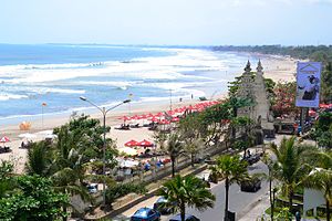
Denpasar
City and capital of Bali, Indonesia
Distance: Approx. 2303 meters
Latitude and longitude: -8.67166667,115.23388889
Denpasar (Indonesian pronunciation: [denˈpasar]; Balinese: ᬤᬾᬦ᭄ᬧᬲᬃ Roman: Dénpasar) is the capital city of the province of Bali, Indonesia. Denpasar is the main gateway to the Bali island, the city is also a hub for other cities in the Lesser Sunda Islands. With the rapid growth of the tourism industry in Bali, Denpasar has encouraged and promoted business activities and ventures, contributing to it having the highest growth rate in Bali Province.
Ngurah Rai Stadium
Stadium in Indonesia
Distance: Approx. 2485 meters
Latitude and longitude: -8.650697,115.223508
Ngurah Rai Stadium is a multi-purpose stadium in Denpasar, Indonesia. It is currently used mostly for football matches. It is the home of the Perseden Denpasar football club.
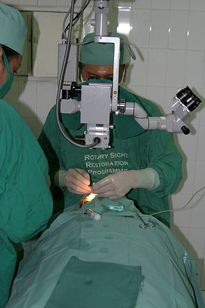
Bali Mandara Eye Hospital
Hospital in Bali, Indonesia
Distance: Approx. 2293 meters
Latitude and longitude: -8.6525,115.2232
The Bali Mandara Eye Hospital (Indonesian: Rumah Sakit Mata Bali Mandara, until 2013 Australia Bali Memorial Eye Centre or ABMEC) is an ophthalmology clinic and day surgery centre in Indonesia, built in memory of the 2002 Bali bombings.

Roman Catholic Diocese of Denpasar
Roman Catholic diocese in Indonesia
Distance: Approx. 2320 meters
Latitude and longitude: -8.65,115.217
The Roman Catholic Diocese of Denpasar (Latin: Denpasaren(sis)) is a diocese of the ecclesiastical province of Ende, in Indonesia. The diocese encompasses the predominantly Hindu province of Bali and the mostly Muslim province of West Nusa Tenggara and has its see in Denpasar, the capital city of Bali.

Bali Museum
Distance: Approx. 1566 meters
Latitude and longitude: -8.6575,115.21852778
The Bali Museum is a museum of art and history located in Denpasar, Bali, Indonesia.
Bajra Sandhi Monument
Monument and museum in Bali
Distance: Approx. 2303 meters
Latitude and longitude: -8.67166667,115.23388889
Bajra Sandhi Monument is a monument to the struggles of the Balinese people throughout history. The monument is located in front of the Bali Governor's Office in Denpasar, Indonesia, on the island of Bali. The monument was built in 1987, and inaugurated by President Megawati Sukarnoputri on 14 June 2003.
University of National Education
Private university in Bali, Indonesia
Distance: Approx. 1709 meters
Latitude and longitude: -8.67722222,115.22694444
University of National Education (Indonesian: Universitas Pendidikan Nasional, abbreviated as Undiknas), is a private university in Denpasar, Bali, Indonesia. This university was established by I Gusti Ngurah Gorda and Ketut Sambereg. It was previously known as Akademi Keuangan dan Perbankan (AKABA) and was established on 17 February 1969 by Yayasan Pendidikan Kejuruan Nasional (YPKN).

Holy Spirit Cathedral, Denpasar
Church in Denpasar, Indonesia
Distance: Approx. 1896 meters
Latitude and longitude: -8.674019,115.229851
The Holy Spirit Cathedral (Indonesian: Katedral Roh Kudus) also called Denpasar Cathedral (Katedral Denpasar) is a religious building affiliated with the Catholic Church located in the city of Denpasar on the island of Bali in the south of the Asian country of Indonesia. The Parish and Cathedral of Denpasar are served by the priests of the Congregation of the Divine Word. The present structure was built between 1993 and 1998.

Pura Maospahit
Balinese Hindu temple in Indonesia
Distance: Approx. 1883 meters
Latitude and longitude: -8.653794,115.210089
Pura Maospahit is a Balinese Hindu temple or pura located in Denpasar, Bali. The pura is known for its bare red brick architecture, reminiscent of the architecture of the 13th-century Majapahit Kingdom, hence the name. Pura Maospahit is the only pura in Bali which was built using a concept known as Panca Mandala where the most sacred area is situated at the center instead of at the direction of the mountain.
Prof. Ngoerah Hospital
Hospital in Bali, Indonesia
Distance: Approx. 626 meters
Latitude and longitude: -8.676,115.212
Prof. dr. I.G.N.G. Ngoerah Central General Hospital (Indonesian: Rumah Sakit Umum Pusat Prof.
Kompyang Sujana Stadium
Stadium in Indonesia
Distance: Approx. 2854 meters
Latitude and longitude: -8.6526,115.1944
Kompyang Sujana Stadium is a multi-purpose stadium in Denpasar, Bali, Indonesia, and the home of Indonesia Liga 3 club Perseden Denpasar. It has a capacity of 7,000 spectators. In 2021, the field renovation has been carried out.
Denpasar metropolitan area
Place in Bali, Indonesia
Distance: Approx. 2303 meters
Latitude and longitude: -8.67166667,115.23388889
Denpasar metropolitan area (Indonesian: Wilayah metropolitan Denpasar; Balinese: Wawengkon métropolitan Dénpasar) or officially Sarbagita; (acronym of "Denpasar-Badung-Gianyar-Tabanan") is a metropolitan area located in Indonesia. This area includes Denpasar city and its surrounding areas such as Badung Regency, Gianyar Regency, and Tabanan Regency. This region of Bali province.
Weather in this IP's area
broken clouds
28 Celsius
33 Celsius
28 Celsius
28 Celsius
1015 hPa
89 %
1015 hPa
1012 hPa
10000 meters
3.09 m/s
90 degree
75 %
05:59:33
18:13:33