45.128.226.206 - IP Lookup: Free IP Address Lookup, Postal Code Lookup, IP Location Lookup, IP ASN, Public IP
Country:
 Finland
Region:
City:
Location:
Time Zone:
Postal Code:
ISP:
ASN:
language:
User-Agent:
Proxy IP:
Blacklist:
IP information under different IP Channel
ip-api
Country
Region
City
ASN
Time Zone
ISP
Blacklist
Proxy
Latitude
Longitude
Postal
Route
db-ip
Country
Region
City
ASN
Time Zone
ISP
Blacklist
Proxy
Latitude
Longitude
Postal
Route
IPinfo
Country
Region
City
ASN
Time Zone
ISP
Blacklist
Proxy
Latitude
Longitude
Postal
Route
IP2Location
45.128.226.206Country
fiRegion
etela-karjala
City
imatra
Time Zone
Europe/Helsinki
ISP
Language
User-Agent
Latitude
Longitude
Postal
ipdata
Country
Region
City
ASN
Time Zone
ISP
Blacklist
Proxy
Latitude
Longitude
Postal
Route
Popular places and events near this IP address
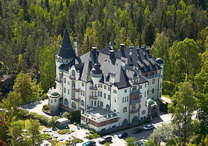
Imatra
Town in southeastern Finland
Distance: Approx. 1495 meters
Latitude and longitude: 61.18333333,28.76666667
Imatra is a town in Finland, located in the southeastern interior of the country. Imatra is located in the region of South Karelia, on Lake Saimaa, the River Vuoksi. The population of Imatra is approximately 25,000, while the sub-region has a population of approximately 37,000.
Svetogorsk
Town in Leningrad Oblast, Russia
Distance: Approx. 8072 meters
Latitude and longitude: 61.11666667,28.85
Svetogorsk (Russian: Светогорск, Finnish: Enso) is an industrial town in Vyborgsky District of Leningrad Oblast, Russia, located on the Karelian Isthmus, on the Vuoksi River. It is located one kilometre (0.62 mi) from the border with Finland, five kilometres (3.1 mi) from the Finnish town of Imatra, and 207 kilometers (129 mi) from St. Petersburg.

Church of the Three Crosses
Church in Imatra, Finland
Distance: Approx. 9114 meters
Latitude and longitude: 61.23666667,28.85611111
Church of the Three Crosses (Finnish: Kolmen Ristin kirkko; also known as Vuoksenniska Church) is a Lutheran church located in Kaukopää, Imatra, Finland. The church was designed by Alvar Aalto and completed in 1958. It is said to be Aalto's most original church design.

Imatrankoski
Rapid in Imatra, Finland
Distance: Approx. 1168 meters
Latitude and longitude: 61.1695,28.77363889
Imatrankoski (The Imatra Rapids) are rapids on the Vuoksi in Imatra, Finland. It has been a famous tourist attraction since the late 1700s. Imatrankoski is also one of the National landscapes of Finland.

Imatra shooting
Shooting incident in Imatra, Finland, on 3-4 December 2016
Distance: Approx. 925 meters
Latitude and longitude: 61.1713,28.7696
The Imatra shooting occurred on 4 December 2016 in the Finnish town of Imatra when Jori Juhani Lasonen, a 23-year-old Imatra resident, shot three people dead in the town centre. According to the psychological evaluation, Lasonen was not criminally responsible at the time of the shootings. Therefore, The South Karelia District Court did not sentence him to prison, but instead committed him to involuntary psychiatric treatment.

Imatra Circuit
Defunct Finnish motorsport race track
Distance: Approx. 2191 meters
Latitude and longitude: 61.17783333,28.79125
The Imatra Circuit is a motorsport street circuit in Imatra, Finland. The circuit has existed in two versions, and has been exclusively used for the "Imatranajo" motorcycle road race. From 1962 to 1978 a 6.030 km (3.747 mi) clockwise street circuit in the east of the town of Imatra was used.

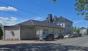
Imatra railway station
Railway station in Imatra, Finland
Distance: Approx. 2975 meters
Latitude and longitude: 61.19583333,28.77666667
The Imatra railway station (Finnish: Imatran rautatieasema, Swedish: Imatra järnvägsstation) is located in the town of Imatra, Finland, in the district of Mansikkala. It is located along the Kouvola–Joensuu railway, and its neighboring stations are Joutseno in the west and Simpele in the east.

Ukonniemi Stadium
Pesäpallo stadium in Imatra, Finland
Distance: Approx. 3038 meters
Latitude and longitude: 61.196983,28.730593
Ukonniemi Stadium is a pesäpallo stadium located in Imatra, Finland. Since its opening in 2015, it has been the home field of the Imatran Pallo-Veikot, a Superpesis team. The Ukonniemi Stadium is a multi-purpose stadium, that serves as a baseball stadium in summer and a ski stadium in winter.
Weather in this IP's area
overcast clouds
-4 Celsius
-7 Celsius
-4 Celsius
-4 Celsius
1041 hPa
95 %
1041 hPa
1032 hPa
10000 meters
1.85 m/s
2.04 m/s
268 degree
92 %