Country:
 Turkey
Region:
City:
Latitude and Longitude:
Time Zone:
Postal Code:
IP information under different IP Channel
ip-api
Country
Region
City
ASN
Time Zone
ISP
Blacklist
Proxy
Latitude
Longitude
Postal
Route
IPinfo
Country
Region
City
ASN
Time Zone
ISP
Blacklist
Proxy
Latitude
Longitude
Postal
Route
MaxMind
Country
Region
City
ASN
Time Zone
ISP
Blacklist
Proxy
Latitude
Longitude
Postal
Route
Luminati
Country
TRASN
Time Zone
Europe/Istanbul
ISP
PENTECH BILISIM TEKNOLOJILERI SANAYI VE TICARET LIMITED SIRKETi
Latitude
Longitude
Postal
db-ip
Country
Region
City
ASN
Time Zone
ISP
Blacklist
Proxy
Latitude
Longitude
Postal
Route
ipdata
Country
Region
City
ASN
Time Zone
ISP
Blacklist
Proxy
Latitude
Longitude
Postal
Route
Popular places and events near this IP address

Osmangazi
District and municipality in Bursa, Turkey
Distance: Approx. 6721 meters
Latitude and longitude: 40.19833333,29.06
Osmangazi is a municipality and district of Bursa Province, Turkey. Its area is 621 km2, and its population is 891,250 (2022). It is one of the central metropolitan districts of the city of Bursa, as well as the fourth largest overall municipality in Turkey.
Bursa Anadolu Lisesi
Public school in Bursa, Turkey
Distance: Approx. 6511 meters
Latitude and longitude: 40.2104,29.0184
Bursa Anatolian High School (Turkish: Bursa Anadolu Lisesi; BAL), is a public boarding secondary school in Bursa, Turkey. BAL is one of the most prominent high schools in the West Anatolian area. It was established in 1970 as Education College (Maarif Koleji) and later was renamed as Bursa Anatolian High School becoming the first Anatolian High School in Bursa Province.
Mayor Synagogue (Bursa)
Former synagogue in Bursa, Turkey
Distance: Approx. 4162 meters
Latitude and longitude: 40.2292,29.0917
The Mayor Synagogue (Turkish: Sinagoga Mayor), or Synagogue Mejor, is a former Jewish congregation and synagogue located on Arap Şükrü (Sakarya) Street in Bursa, Turkey. No longer used as a synagogue, the building is used as a mikveh.
Demirtaş Dam
Dam in Turkey
Distance: Approx. 5525 meters
Latitude and longitude: 40.288,29.1141
Demirtaş Dam is a dam in Turkey. It was built in 1982 and commissioned in 1983. The development was backed by the Turkish State Hydraulic Works.

Centennial Atatürk Stadium
Stadium in Bursa, Turkey
Distance: Approx. 6931 meters
Latitude and longitude: 40.21083333,29.00944444
The Centennial Atatürk Stadium (Turkish: Yüzüncü Yıl Atatürk Stadyumu) is an association football stadium in Bursa, Turkey. It has a capacity of 43,361 spectators and is home to Bursaspor of the TFF Second League, replacing the Bursa Atatürk Stadium. The stadium is called the Bursa Metropolitan Municipality Stadium (Turkish: Bursa Büyükşehir Belediye Stadyumu) in UEFA competitions.

Abdal Bridge (Bursa)
Bridge in Turkey
Distance: Approx. 6285 meters
Latitude and longitude: 40.21625,29.01283333
The Abdal Bridge (Turkish: Abdal Köprüsü) is a stone arch bridge in Bursa, Turkey. It was constructed in 1669 to carry the road to Mudanya across the Nilüfer River. Today it connects the Acemler and Hürriyet quarters of Bursa.
Bursa Karagöz Museum
Distance: Approx. 6955 meters
Latitude and longitude: 40.202029,29.02714
Bursa Karagöz Museum (Turkish: Bursa Karagöz Müzesi) is a museum located at Osmangazi in Bursa, northwestern Turkey, dedicated to the folkloric shadow play figures Karagöz and Hacivat. It was established in 2007.
Basilica Therma (Bithynia)
Town of ancient Bithynia
Distance: Approx. 6112 meters
Latitude and longitude: 40.205714,29.042755
Basilica Therma was a town located of ancient Bithynia, near Prusa. Its site is located near Çekirge, Asiatic Turkey.
Ahmetbey, Osmangazi
Village in Turkey
Distance: Approx. 6786 meters
Latitude and longitude: 40.2934,28.9959
Ahmetbey is a neighbourhood in the municipality and district of Osmangazi, Bursa Province in Turkey. Its population is 531 (2022).
Bursa Sports High School
School in Turkey
Distance: Approx. 6191 meters
Latitude and longitude: 40.20633,29.08612
Bursa Sports High School (Turkish: Bursa Spor Lisesi), full name Bursa BTSO Celal Sönmez Spor Lisesi (BTSO is for Bursa Commerce and Industry Chamber), is a government-funded co-educational comprehensive and specialist secondary school, with speciality in sports, located in Osmangazi district of Bursa Province, Turkey. The high school has been serving in this status since 2006. The school has three indoor sport halls.
Bursa gas power plant
Gas fired power station in Turkey
Distance: Approx. 4293 meters
Latitude and longitude: 40.29611111,29.07388889
Bursa gas power plant (Turkish: Bursa Doğalgaz Çevrim Santrali) is a gas-fired power station in Bursa Province western Turkey.
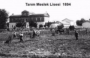
Bursa Agriculture Vocational High School
Vocational school in Turkey
Distance: Approx. 6375 meters
Latitude and longitude: 40.22787,28.99838
Bursa Agriculture Vocational High School (Turkish: Tarım Meslek Lisesi - Bursa), also known as Hamidiye Vocational and Technical Anatolian High School ("Hamidiye Mesleki ve Teknik Anadolu Lisesi") is a vocational high school for agriculture in Bursa, Turkey. It was established during the Ottoman Empire in 1891.
Weather in this IP's area
scattered clouds
22 Celsius
21 Celsius
22 Celsius
22 Celsius
1011 hPa
37 %
1011 hPa
1000 hPa
10000 meters
1.29 m/s
1.8 m/s
336 degree
35 %
07:09:13
18:31:50