Country:
 USA
USARegion:
City:
Latitude and Longitude:
Time Zone:
Postal Code:
IP information under different IP Channel
ip-api
Country
Region
City
ASN
Time Zone
ISP
Blacklist
Proxy
Latitude
Longitude
Postal
Route
IPinfo
Country
Region
City
ASN
Time Zone
ISP
Blacklist
Proxy
Latitude
Longitude
Postal
Route
MaxMind
Country
Region
City
ASN
Time Zone
ISP
Blacklist
Proxy
Latitude
Longitude
Postal
Route
Luminati
Country
USASN
Time Zone
America/Chicago
ISP
Andrews & Arnold Ltd
Latitude
Longitude
Postal
db-ip
Country
Region
City
ASN
Time Zone
ISP
Blacklist
Proxy
Latitude
Longitude
Postal
Route
ipdata
Country
Region
City
ASN
Time Zone
ISP
Blacklist
Proxy
Latitude
Longitude
Postal
Route
Popular places and events near this IP address
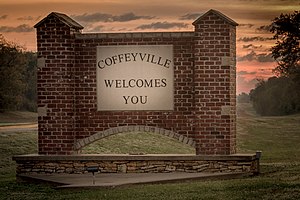
Coffeyville, Kansas
City in Montgomery County, Kansas
Distance: Approx. 9591 meters
Latitude and longitude: 37.035,-95.63
Coffeyville is a city in southeastern Montgomery County, Kansas, United States, located along the Verdigris River in the state's southeastern region. As of the 2020 census, the population of the city was 8,826. Coffeyville is the most populous city of Montgomery County, and the home to Coffeyville Community College.

Dearing, Kansas
City in Montgomery County, Kansas
Distance: Approx. 4392 meters
Latitude and longitude: 37.05333333,-95.69527778
Dearing is a city in Montgomery County, Kansas, United States. As of the 2020 census, the population of the city was 382.
Shakespeare at Winedale
Theatre criticism program affiliated with the University of Texas at Austin
Distance: Approx. 4431 meters
Latitude and longitude: 37.0625,-95.677068
The Shakespeare at Winedale program, created in 1970 by James B. "Doc" Ayres, is a program affiliated with the University of Texas at Austin, dedicated to Shakespearean criticism through performance of the plays. The main performance space at Winedale, located in Round Top, Texas, is a barn donated to the University of Texas by Ima Hogg.

Independence Municipal Airport (Kansas)
Airport in Independence Township, Montgomery County
Distance: Approx. 9553 meters
Latitude and longitude: 37.15833333,-95.77833333
Independence Municipal Airport (IATA: IDP, ICAO: KIDP, FAA LID: IDP) is six miles southwest of Independence, in Montgomery County, Kansas. The National Plan of Integrated Airport Systems for 2011–2015 categorized it a general aviation facility.

Bengt Sjostrom Theatre
Distance: Approx. 4436 meters
Latitude and longitude: 37.0625,-95.677
The Bengt Sjostrom Theatre (usually referred to as Starlight Theatre by local residents) is an outdoor community theater located on the Rock Valley College campus in Rockford, Illinois. It houses the Rock Valley College Starlight Theatre, one of two theatres operated by the college (the other being the indoor Rock Valley College Studio Theatre). The Bengt Sjostrom Theatre was constructed in 1983 and is dedicated to the memory of Bengt Sjostrom, builder and civic leader, who was the general contractor when the college buildings were constructed, from 1967 to 1971.

Independence Army Airfield
Distance: Approx. 9553 meters
Latitude and longitude: 37.15833333,-95.77833333
Independence Army Airfield was a World War II training base of the United States Army Air Forces Central Flying Training Command (CFTC). It is currently the city-owned Independence Municipal Airport.
KUSN
Radio station in Dearing, Kansas
Distance: Approx. 2144 meters
Latitude and longitude: 37.10777778,-95.72277778
KUSN 98.1 FM is a radio station licensed to Dearing, Kansas.
Rock Valley College Starlight Theatre
Distance: Approx. 4436 meters
Latitude and longitude: 37.0625,-95.677
Starlight Theatre is an outdoor theatre operated by Rock Valley College in Rockford, Illinois. Performances are held in the outdoor Bengt Sjostrom Theatre. Operations of Rock Valley College Studio Theatre, an indoor black box theatre, were suspended in 2016.

Onion Creek Bridge (Coffeyville, Kansas)
United States historic place
Distance: Approx. 8749 meters
Latitude and longitude: 37.02583333,-95.65638889
The Onion Creek Bridge was built in 1911 near Coffeyville, Kansas. The pin-connected steel Parker through-truss bridge is 104 feet (32 m) long. It is unusual in possessing vertical end posts, one of only two such bridges in Kansas.
Jefferson, Kansas
Unincorporated community in Montgomery County, Kansas
Distance: Approx. 4954 meters
Latitude and longitude: 37.11222222,-95.76138889
Jefferson is an unincorporated community in Montgomery County, Kansas, United States.

Emil W. Roesky, Jr., Memorial Aviation Heritage Museum
Aviation museum in Coffeyville, Kansas
Distance: Approx. 7018 meters
Latitude and longitude: 37.0655,-95.6402
The Emil W. Roesky, Jr., Memorial Aviation Heritage Museum is an aviation museum located in Coffeyville, Kansas.
Weather in this IP's area
clear sky
24 Celsius
23 Celsius
24 Celsius
24 Celsius
1026 hPa
20 %
1026 hPa
996 hPa
10000 meters
2.57 m/s
170 degree
07:34:38
18:40:27