Country:
Region:
City:
Latitude and Longitude:
Time Zone:
Postal Code:
IP information under different IP Channel
ip-api
Country
Region
City
ASN
Time Zone
ISP
Blacklist
Proxy
Latitude
Longitude
Postal
Route
Luminati
Country
ASN
Time Zone
Europe/Paris
ISP
Techcrea Solutions SAS
Latitude
Longitude
Postal
IPinfo
Country
Region
City
ASN
Time Zone
ISP
Blacklist
Proxy
Latitude
Longitude
Postal
Route
db-ip
Country
Region
City
ASN
Time Zone
ISP
Blacklist
Proxy
Latitude
Longitude
Postal
Route
ipdata
Country
Region
City
ASN
Time Zone
ISP
Blacklist
Proxy
Latitude
Longitude
Postal
Route
Popular places and events near this IP address

Saint-Amand-les-Eaux
Commune in Hauts-de-France, France
Distance: Approx. 1931 meters
Latitude and longitude: 50.4486,3.4281
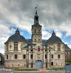
Saint-Amand-les-Eaux (French pronunciation: [sɛ̃t‿amɑ̃ lez‿o]; former Dutch: Sint-Amands-aan-de-Skarpe) is a commune in the Nord department, northern France. It lies on the river Scarpe, 12 km northwest of Valenciennes. In French, the town people are named Amandinois (m), Amandinoise (f).
Nivelle
Commune in Hauts-de-France, France
Distance: Approx. 4290 meters
Latitude and longitude: 50.4733,3.4681
Nivelle (French pronunciation: [nivɛl] ) is a commune in the Nord department in northern France.

Lecelles
Commune in Hauts-de-France, France
Distance: Approx. 5368 meters
Latitude and longitude: 50.4714,3.3953
Lecelles (French pronunciation: [ləsɛl]) is a commune in the Nord department in northern France.
Château-l'Abbaye
Commune in Hauts-de-France, France
Distance: Approx. 5778 meters
Latitude and longitude: 50.4847,3.48
Château-l'Abbaye (French pronunciation: [ʃɑto labe.i]; Picard: Catiau-l'Abi) is a commune of the Nord department in northern France.

Bruille-Saint-Amand
Commune in Hauts-de-France, France
Distance: Approx. 5506 meters
Latitude and longitude: 50.4733,3.5008
Bruille-Saint-Amand (French pronunciation: [bʁɥij sɛ̃.t‿amɑ̃]) is a commune in the Nord department in northern France.
Hasnon
Commune in Hauts-de-France, France
Distance: Approx. 4688 meters
Latitude and longitude: 50.421,3.387
Hasnon (French pronunciation: [anɔ̃]) is a commune in the Nord department in northern France.
Millonfosse
Commune in Hauts-de-France, France
Distance: Approx. 4058 meters
Latitude and longitude: 50.436,3.391
Millonfosse is a commune in the Nord department in northern France.
Thun-Saint-Amand
Commune in Hauts-de-France, France
Distance: Approx. 4954 meters
Latitude and longitude: 50.4808,3.4597
Thun-Saint-Amand (French pronunciation: [tœ̃ sɛ̃.t‿amɑ̃]) is a commune in the Nord department in northern France.
Saint-Amand Abbey
Former abbey in Nord, France
Distance: Approx. 1992 meters
Latitude and longitude: 50.44972222,3.42861111
Saint-Amand Abbey (Abbaye de Saint-Amand), once known as Elno, Elnon or Elnone Abbey, is a former Benedictine abbey in Saint-Amand-les-Eaux, Nord, France.

Trouée d'Arenberg
Cobbled road used in Paris-Roubaix
Distance: Approx. 4921 meters
Latitude and longitude: 50.399,3.4125
The Trouée d'Arenberg or Tranchée de Wallers-Arenberg (English: Trench of Arenberg) is a 2.3 km long cobbled road in the municipality of Wallers in Northern France, in the Département Nord. The road's official name is La Drève des Boules d'Hérin ("Bullet Alley of Hérin") and crosses the Forêt de Raismes-Saint-Amand-Wallers, outside France better known as the Forest of Arenberg. It is best known from the annual cycling classic Paris–Roubaix held in April, where it is one of the most difficult passages of the race.

Compagnie des mines d'Anzin
French mining company
Distance: Approx. 5511 meters
Latitude and longitude: 50.4,3.5
The Compagnie des mines d'Anzin (Anzin Mining Company) was a large French mining company in the coal basin of Nord-Pas-de-Calais in northern France. It was established in 1756 and operated for almost 200 years. The company used innovative pumping technology to support deep mining operations in the rich bituminous coalfield.
Canton of Saint-Amand-les-Eaux
Distance: Approx. 1948 meters
Latitude and longitude: 50.45,3.43
The canton of Saint-Amand-les-Eaux is an administrative division of the Nord department, northern France. It was created at the French canton reorganisation which came into effect in March 2015. Its seat is in Saint-Amand-les-Eaux.
Weather in this IP's area
overcast clouds
5 Celsius
1 Celsius
5 Celsius
6 Celsius
1007 hPa
71 %
1007 hPa
1003 hPa
10000 meters
6.71 m/s
10.28 m/s
280 degree
88 %
08:09:11
16:54:58


