Country:
 France
Region:
City:
Latitude and Longitude:
Time Zone:
Postal Code:
IP information under different IP Channel
ip-api
Country
Region
City
ASN
Time Zone
ISP
Blacklist
Proxy
Latitude
Longitude
Postal
Route
IPinfo
Country
Region
City
ASN
Time Zone
ISP
Blacklist
Proxy
Latitude
Longitude
Postal
Route
MaxMind
Country
Region
City
ASN
Time Zone
ISP
Blacklist
Proxy
Latitude
Longitude
Postal
Route
Luminati
Country
 US
USASN
Time Zone
America/Chicago
ISP
Association Grenode
Latitude
Longitude
Postal
db-ip
Country
Region
City
ASN
Time Zone
ISP
Blacklist
Proxy
Latitude
Longitude
Postal
Route
ipdata
Country
Region
City
ASN
Time Zone
ISP
Blacklist
Proxy
Latitude
Longitude
Postal
Route
Popular places and events near this IP address

Gouzon
Commune in Nouvelle-Aquitaine, France
Distance: Approx. 4379 meters
Latitude and longitude: 46.1925,2.2394
Gouzon (French pronunciation: [ɡuzɔ̃]; Auvergnat: Gosom) is a commune in the Creuse department in central France.
Bord-Saint-Georges
Commune in Nouvelle-Aquitaine, France
Distance: Approx. 7596 meters
Latitude and longitude: 46.2611,2.2997
Bord-Saint-Georges (French pronunciation: [bɔʁ sɛ̃ ʒɔʁʒ]; Occitan: Bòrn Sent Jòrge) is a commune in the Creuse department in the Nouvelle-Aquitaine region in central France.

La Celle-sous-Gouzon
Commune in Nouvelle-Aquitaine, France
Distance: Approx. 1355 meters
Latitude and longitude: 46.2156,2.2108
La Celle-sous-Gouzon (French pronunciation: [la sɛl su ɡuzɔ̃], literally La Celle under Gouzon; Occitan: La Cela de Gosom) is a commune in the Creuse department in the Nouvelle-Aquitaine region in central France.
Domeyrot
Commune in Nouvelle-Aquitaine, France
Distance: Approx. 5095 meters
Latitude and longitude: 46.2508,2.1567
Domeyrot (French pronunciation: [dɔmeʁo]; Occitan: Domeiròt) is a commune in the Creuse department in the Nouvelle-Aquitaine region in central France.
Parsac
Part of Parsac-Rimondeix in Nouvelle-Aquitaine, France
Distance: Approx. 5410 meters
Latitude and longitude: 46.2031,2.1531
Parsac (Auvergnat: Parçac) is a former commune in the Creuse department in the Limousin region in central France. On 1 January 2016, it was merged into the new commune Parsac-Rimondeix.
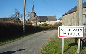
Saint-Silvain-sous-Toulx
Commune in Nouvelle-Aquitaine, France
Distance: Approx. 4755 meters
Latitude and longitude: 46.2631,2.1794
Saint-Silvain-sous-Toulx (French pronunciation: [sɛ̃ silvɛ̃ su tul], literally Saint-Silvain under Toulx; Auvergnat: Sant Sauve de Tol) is a commune in the Creuse department in central France.

Toulx-Sainte-Croix
Commune in Nouvelle-Aquitaine, France
Distance: Approx. 6457 meters
Latitude and longitude: 46.2856,2.2144
Toulx-Sainte-Croix (French pronunciation: [tul sɛ̃t kʁwa]; Occitan: Tol Senta Crotz) is a commune in the Creuse department in the Nouvelle-Aquitaine region in central France.
Trois-Fonds
Commune in Nouvelle-Aquitaine, France
Distance: Approx. 2895 meters
Latitude and longitude: 46.2514,2.2289
Trois-Fonds (French: [tʁwɑ fɔ̃]; Occitan: Tres Fonts) is a commune in the Creuse department in the Nouvelle-Aquitaine region in central France.
Communauté de communes du Carrefour des Quatre Provinces
Former communauté de communes in Nouvelle-Aquitaine, France
Distance: Approx. 4140 meters
Latitude and longitude: 46.1947,2.2388
The communauté de communes du Carrefour des Quatre Provinces was located in the Creuse département of the Nouvelle-Aquitaine region of central France. It was created in January 1999. It was merged into the new Communauté de communes Creuse Confluence in January 2017.
Canton of Jarnages
Former canton in Nouvelle-Aquitaine, France
Distance: Approx. 3805 meters
Latitude and longitude: 46.21666667,2.16694444
The Canton of Jarnages is a former canton situated in the Creuse département and in the Limousin region of central France. It was disbanded following the French canton reorganisation which came into effect in March 2015. It consisted of 10 communes, which joined the new canton of Gouzon in 2015.

Parsac-Rimondeix
Commune in Nouvelle-Aquitaine, France
Distance: Approx. 5555 meters
Latitude and longitude: 46.203,2.151
Parsac-Rimondeix (Auvergnat: Parçac e Rimondés) is a commune in the Creuse department of central France. The municipality was established on 1 January 2016 and consists of the former communes of Parsac and Rimondeix.
Canton of Gouzon
Distance: Approx. 4649 meters
Latitude and longitude: 46.19,2.24
The canton of Gouzon is an administrative division of the Creuse department, in central France. It was created at the French canton reorganisation which came into effect in March 2015. Its seat is in Gouzon.
Weather in this IP's area
light rain
12 Celsius
12 Celsius
12 Celsius
12 Celsius
1014 hPa
98 %
1014 hPa
964 hPa
158 meters
2.33 m/s
5.32 m/s
284 degree
100 %
08:12:32
18:59:36