43.248.71.230 - IP Lookup: Free IP Address Lookup, Postal Code Lookup, IP Location Lookup, IP ASN, Public IP
Country:
Region:
City:
Location:
Time Zone:
Postal Code:
IP information under different IP Channel
ip-api
Country
Region
City
ASN
Time Zone
ISP
Blacklist
Proxy
Latitude
Longitude
Postal
Route
Luminati
Country
Region
mh
City
mumbai
ASN
Time Zone
Asia/Kolkata
ISP
Seven Star Digital Network Private Limited
Latitude
Longitude
Postal
IPinfo
Country
Region
City
ASN
Time Zone
ISP
Blacklist
Proxy
Latitude
Longitude
Postal
Route
IP2Location
43.248.71.230Country
Region
maharashtra
City
santa cruz
Time Zone
Asia/Kolkata
ISP
Language
User-Agent
Latitude
Longitude
Postal
db-ip
Country
Region
City
ASN
Time Zone
ISP
Blacklist
Proxy
Latitude
Longitude
Postal
Route
ipdata
Country
Region
City
ASN
Time Zone
ISP
Blacklist
Proxy
Latitude
Longitude
Postal
Route
Popular places and events near this IP address
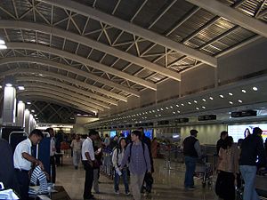
Santacruz, Mumbai
Suburb in Mumbai Suburban, Maharashtra, India
Distance: Approx. 747 meters
Latitude and longitude: 19.081667,72.841389
Santacruz or Santa Cruz (Pronunciation: [saːn̪t̪akɾuːz]) is a suburb of Mumbai. The Santacruz railway station on the Mumbai Suburban Railway, the domestic terminal (T1) of the Chhatrapati Shivaji Maharaj International Airport, and one campus of the University of Mumbai, are all located in Santacruz (East). Santacruz and its neighbouring suburb Khar fall under the H East and H West wards of the Municipal Corporation of Greater Mumbai.
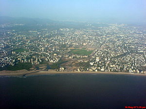
Juhu
Place in Maharashtra, India
Distance: Approx. 1918 meters
Latitude and longitude: 19.1,72.83
Juhu (Pronunciation: [d͡ʒuɦuː]) is a suburb of Mumbai. It is known for the sprawling Juhu Beach. It is surrounded by the Arabian Sea to the west, Versova to the north, Vile Parle to the east and Santacruz to the south.
Vile Parle
Neighborhood in Mumbai
Distance: Approx. 1918 meters
Latitude and longitude: 19.1,72.83
Vile Parle (IPA: [ʋile paːɾle], also known as Parla), is a suburb and also the name of the railway station in the Western suburb of Mumbai. Vile Parle has a significantly strong base of Marathi population. It serves as the location of the first Parle factory which ceased operations in the year 2016.
Pali Hill
Neighbourhood in Mumbai Suburban - Bandra + Khar, Maharashtra, India
Distance: Approx. 1794 meters
Latitude and longitude: 19.068263,72.828363
Pali Hill is an affluent residential area spread across the adjoined suburbs of Bandra and Khar in Mumbai, India (sharing postal codes 400050 and 400052 respectively).
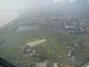
Juhu Aerodrome
Airport in Maharashtra, India
Distance: Approx. 1644 meters
Latitude and longitude: 19.09805556,72.83388889
Juhu Aerodrome (ICAO: VAJJ) is located in Juhu, an upmarket residential suburb of Mumbai, Maharashtra, India. It is served primarily by general aviation aircraft and helicopters. It was founded in 1928 as one of India's first civil aviation airport, 4 years after the Netaji Subhash Chandra Bose International Airport (CCU) was opened In 1932, JRD Tata landed at the Juhu Aerodrome, inaugurating India's first scheduled commercial mail service.

Khar, Mumbai
Suburb in Mumbai Suburban, Maharashtra, India
Distance: Approx. 1856 meters
Latitude and longitude: 19.06666667,72.83333333
Khar (Marathi pronunciation: [kʰaːɾ]) is an affluent suburb of Mumbai, north of Bandra and south of Santacruz, Mumbai. Originally one of the 'villages' that made up the larger Bandra, the present suburb is divided into Khar West and Khar East areas. It is serviced by Khar Road railway station of the Mumbai Suburban Railway network.
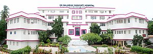
Nanavati hospital
Private Hospital in India
Distance: Approx. 1505 meters
Latitude and longitude: 19.095786,72.839986
Nanavati Max Super Speciality Hospital formerly known as Dr. Balabhai Nanavati Hospital is a private hospital located in Vile Parle, Mumbai, India, which was inaugurated by Jawaharlal Nehru in November 1950 and opened in May 1951. Lately, Dr.

Japan Air Lines Flight 472 (1972)
1972 aviation accident in Bombay, India
Distance: Approx. 1826 meters
Latitude and longitude: 19.09916667,72.83888889
Japan Air Lines Flight 472 was a flight from London to Tokyo via Frankfurt, Rome, Beirut, Tehran, Bombay, Bangkok and Hong Kong. On September 24, 1972, the flight landed at Juhu Aerodrome near Bombay, India instead of the city's much larger Santacruz Airport (now Chhatrapati Shivaji International Airport) and overran the runway, resulting in the aircraft being written off after being damaged beyond economic repair.
St. Xavier's High School, Vile Parle
Catholic school in Vile Parle West, Mumbai
Distance: Approx. 1982 meters
Latitude and longitude: 19.099377,72.842586
St. Xavier's High School & Junior College, formerly called St. Xavier's High School, is a Catholic school located in the Mumbai Suburban district in Vile Parle West.
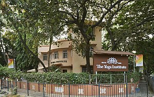
The Yoga Institute
Non-profit yoga center
Distance: Approx. 932 meters
Latitude and longitude: 19.085104,72.843153
The Yoga Institute (abbreviated as TYI) is a government recognized non-profit organisation, known as the oldest organized yoga center in the world. It was founded in 1918 by Shri Yogendra (1897-1989), who was one of the important figures in the modern revival of yoga. It is headquartered in Santacruz, Mumbai, India.

Hinduja Healthcare Surgical
Hospital in Maharashtra, India
Distance: Approx. 1709 meters
Latitude and longitude: 19.067969,72.835383
P.D. Hinduja Hospital is a multi-specialty, tertiary-care hospital located in Khar, Mumbai, India, owned and operated by London-based Hinduja Group through Hinduja Healthcare Limited, which also operates Hinduja Hospital. Its chief executive officer is Gautam Khanna. It has plans to expand its nationwide capacity to 5,000 beds, besides setting up radiology and pathology diagnostic centres, emergency ambulance services and pharmacy retail outlets across India.
Ghanteshwar Temple Mumbai
Distance: Approx. 1330 meters
Latitude and longitude: 19.07144,72.83606
The Ghanteshwar Temple is a Hindu temple to the god Hanuman in Khar (West), Mumbai, India.
Weather in this IP's area
haze
24 Celsius
24 Celsius
24 Celsius
24 Celsius
1013 hPa
57 %
1013 hPa
1012 hPa
2500 meters