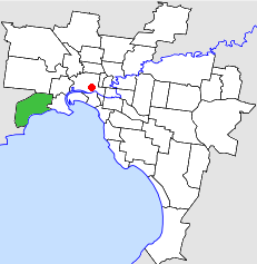
Country:
 Australia
Region:
City:
Latitude and Longitude:
Time Zone:
Postal Code:
IP information under different IP Channel
ip-api
Country
Region
City
ASN
Time Zone
ISP
Blacklist
Proxy
Latitude
Longitude
Postal
Route
IPinfo
Country
Region
City
ASN
Time Zone
ISP
Blacklist
Proxy
Latitude
Longitude
Postal
Route
MaxMind
Country
Region
City
ASN
Time Zone
ISP
Blacklist
Proxy
Latitude
Longitude
Postal
Route
Luminati
Country
AURegion
vic
City
melbourne
ASN
Time Zone
Australia/Melbourne
ISP
Virtutel Pty Ltd
Latitude
Longitude
Postal
db-ip
Country
Region
City
ASN
Time Zone
ISP
Blacklist
Proxy
Latitude
Longitude
Postal
Route
ipdata
Country
Region
City
ASN
Time Zone
ISP
Blacklist
Proxy
Latitude
Longitude
Postal
Route
Popular places and events near this IP address

Galvin railway station
Former railway station in Victoria, Australia
Distance: Approx. 439 meters
Latitude and longitude: -37.85527778,144.80722222
Galvin railway station is a closed railway station which was located on the Werribee line of the Melbourne suburban rail system in Australia. It was located adjacent to Maidstone Street, Altona, and was situated between Paisley and Laverton stations.

Altona, Victoria
Suburb of Melbourne, Victoria, Australia
Distance: Approx. 2330 meters
Latitude and longitude: -37.868,144.83
Altona is a suburb in Melbourne, Victoria, Australia, 13 km (8.1 mi) south-west of Melbourne's Central Business District, located within the City of Hobsons Bay local government area. Altona recorded a population of 11,490 at the 2021 census. Altona is a large suburb consisting of low density residential in the south-eastern half and mixed industry in the north-western half.

Altona railway station
Railway station in Altona, Melbourne, Victoria, Australia
Distance: Approx. 2302 meters
Latitude and longitude: -37.8672,144.8301
Altona railway station is located on the Werribee line in Victoria, Australia. It serves the south-west Melbourne suburb of the same name, and opened on 1 December 1917 as Altona Beach. It was renamed Altona on 3 October 1938.

Westona railway station
Railway station in Melbourne, Australia
Distance: Approx. 938 meters
Latitude and longitude: -37.8651,144.8135
Westona railway station is located on the Werribee line in Victoria, Australia. It serves the western Melbourne suburb of Altona, and opened on 21 January 1985. Westona is a crossing loop in the middle of a 10-kilometre-long section of single track between Altona Junction and Laverton.
Mount St. Joseph Girls' College
School in Altona, Victoria, Australia
Distance: Approx. 752 meters
Latitude and longitude: -37.86416667,144.81166667
Mount St. Joseph Girls' College is a Catholic Girls College located in Maidstone Street, Altona, Victoria, Australia. Mount St.
Melbourne Ballpark
Distance: Approx. 2239 meters
Latitude and longitude: -37.86,144.78055556
The Melbourne Ballpark is a baseball park in Laverton, Victoria. It was opened in January 1990, at a cost of A$3.9m, A$2m was contributed by the State Government of Victoria and the remaining A$1.8m contributed by the Australian Federal Government and was constructed by CK Designwork Architects. The stadium has a capacity of approximately 5,000.

Laverton North Power Station
Distance: Approx. 2504 meters
Latitude and longitude: -37.84111111,144.78888889
Laverton North Power Station is a natural gas-powered plant, owned and operated by Snowy Hydro Limited. It is situated in Laverton North, on the south-western outskirts of Melbourne, Victoria, approximately 15 km from the Melbourne Central Business District. It is a peaking power plant, particularly constructed to cater for the growth in Victoria's summer electricity demand, and can be rapidly activated when required.
City of Altona
Local government area in Victoria, Australia
Distance: Approx. 2330 meters
Latitude and longitude: -37.868,144.83
The City of Altona was a local government area about 13 kilometres (8 mi) west of Melbourne, the state capital of Victoria, Australia. The city covered an area of 40.18 square kilometres (15.51 sq mi), and existed from 1957 until 1994.

Cherry Lake (Victoria)
Distance: Approx. 2526 meters
Latitude and longitude: -37.85833333,144.83472222
Cherry Lake is part of historical coastal wetlands in Altona, a suburb of Melbourne, Victoria, Australia. The wetlands were converted to a lake with construction of retaining walls, levees and flow channels. The lake and surrounding reserve is an important wildlife habitat and popular recreational destination.
Truganina Coastal Parklands
Distance: Approx. 2174 meters
Latitude and longitude: -37.87861111,144.805
The Truganina Coastal Parklands are located 15 km west of Melbourne CBD, on the shores of Port Phillip Bay, stretching from Altona to Altona Meadows and adjacent to the Cheetham Wetlands and the Point Cook Coastal Park. They were formed through the 'recycling' of more than 300 hectares of parks and former industrial land and are now the largest cluster of parks on Port Phillip Bay, interlinked by cycling and walking trails and featuring a surprisingly high diversity and abundance of landscapes, natural environment and recreational areas, including beachside recreation, picnic & barbecue facilities, grassfields and wildlife conservation areas. The wetlands form part of the Cheetham and Altona Important Bird Area.

Truganina Explosives Reserve
Former government magazine in City of Hobsons Bay, Australia
Distance: Approx. 2037 meters
Latitude and longitude: -37.8774,144.805903
The Truganina Explosives Reserve was a secure storage facility near Altona in the Australian state of Victoria. It was in operation from 1901 to 1962 to store mainly civilian explosives for mining and construction. The camp included several storage sheds and a jetty, which were connected by a narrow-gauge horse-drawn tramway.
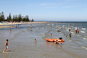
Altona Beach
Beach in Victoria, Australia
Distance: Approx. 1958 meters
Latitude and longitude: -37.87222222,144.82083333
Altona Beach is a beach located in Altona, Victoria, Australia. A long pier is located towards the middle of the beach. From late November through to around Easter each year, volunteers from the Altona Lifesaving Club patrol the beach on the eastern side of the pier.
Weather in this IP's area
broken clouds
14 Celsius
13 Celsius
13 Celsius
14 Celsius
1016 hPa
75 %
1016 hPa
1015 hPa
10000 meters
5.67 m/s
11.19 m/s
294 degree
74 %
06:32:11
18:05:11