Country:
 Papua New Guinea
Region:
City:
Latitude and Longitude:
Time Zone:
Postal Code:
IP information under different IP Channel
ip-api
Country
Region
City
ASN
Time Zone
ISP
Blacklist
Proxy
Latitude
Longitude
Postal
Route
IPinfo
Country
Region
City
ASN
Time Zone
ISP
Blacklist
Proxy
Latitude
Longitude
Postal
Route
MaxMind
Country
Region
City
ASN
Time Zone
ISP
Blacklist
Proxy
Latitude
Longitude
Postal
Route
Luminati
Country
PGRegion
ncd
City
portmoresby
ASN
Time Zone
Pacific/Port_Moresby
ISP
Digitec Communications Limited
Latitude
Longitude
Postal
db-ip
Country
Region
City
ASN
Time Zone
ISP
Blacklist
Proxy
Latitude
Longitude
Postal
Route
ipdata
Country
Region
City
ASN
Time Zone
ISP
Blacklist
Proxy
Latitude
Longitude
Postal
Route
Popular places and events near this IP address

Port Moresby
Capital and largest city of Papua New Guinea
Distance: Approx. 1409 meters
Latitude and longitude: -9.47888889,147.14944444
Port Moresby (; Tok Pisin: Pot Mosbi), also referred to as Pom City or simply Moresby, is the capital and largest city of Papua New Guinea. It is one of the largest cities in the southwestern Pacific (along with Jayapura) outside of Australia and New Zealand. It is located on the shores of the Gulf of Papua, on the south-western coast of the Papuan Peninsula of the island of New Guinea.

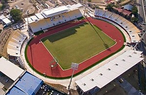
Sir Hubert Murray Stadium
Stadium in Papua New Guinea
Distance: Approx. 1130 meters
Latitude and longitude: -9.466323,147.156674
The Hubert Murray Stadium is a sports venue located in Port Moresby, the capital city of Papua New Guinea. It was developed for the 1969 South Pacific Games on reclaimed land at Konedobu that had previously been shoreline mangroves. The athletics events and the opening and closing ceremonies were held at the new stadium, which was named after Sir Hubert Murray, a former lieutenant governor.
PNG Football Stadium
Stadium in Port Moresby, Papua New Guinea
Distance: Approx. 5707 meters
Latitude and longitude: -9.46833333,147.19833333
PNG Football Stadium, known by the sponsored name of Santos National Football Stadium and previously as Lloyd Robson Oval until 2015, is a sporting ground in Port Moresby, Papua New Guinea. It hosted three games for the 1989–1992 Rugby League World Cup. It has been the home ground for the Papua New Guinea national rugby league team since 1975.
Roman Catholic Archdiocese of Port Moresby
Latin Catholic archdiocese in Papua New Guinea
Distance: Approx. 2263 meters
Latitude and longitude: -9.4667,147.167
The Archdiocese of Port Moresby (Latin: Archidiœcesis Portus Moresbiensis) is a Latin Church ecclesiastical jurisdiction or archdiocese of the Catholic Church in Papua New Guinea. Its cathedral is in St. Mary's Cathedral, in Port Moresby, National Capital District.

Hanuabada
Village in NCD, Papua New Guinea
Distance: Approx. 2339 meters
Latitude and longitude: -9.45,147.13333333
Hanuabada is a coastal village in Papua New Guinea in the outskirts of the nation's capital, Port Moresby. It is the biggest village in the Motuan tribe and is often known by its locals as "HB". Hanuabada means "big village" (hanua "village" + bada "big", the former from Proto-Oceanic (panua) in Motu.
2008 Papua New Guinea floods
Distance: Approx. 4996 meters
Latitude and longitude: -9.5,147.116
The 2008 Papua New Guinea floods displaced roughly 75,000 people located in Papua New Guinea, prompting an international response to provide support for the region. The country was struck by large sea swells on 16 December, apparently caused by "strong storms", which affected over eight provinces and caused at least one death.

Battle of Port Moresby
Distance: Approx. 5094 meters
Latitude and longitude: -9.48154722,147.19024167
The Battle of Port Moresby was an aerial battle fought between the Royal Australian Air Force (RAAF) and United States Army Air Force (USAAF) on one side and the Imperial Japanese Army and Imperial Japanese Navy on the other between 3 February 1942 and 17 August 1943 over Port Moresby, Papua. At the start, the defenders consisted only of Australian Army anti-aircraft batteries and machine-guns, but by late March had been strengthened by the arrival of Kittyhawk fighters from No. 75 Squadron RAAF. However, in just nine days they lost 11 aircraft and only the arrival of replacements enabled the unit to maintain ten serviceable machines.
Sir John Guise Stadium
Distance: Approx. 5147 meters
Latitude and longitude: -9.440893,147.185355
The Sir John Guise Stadium is a multi-sport and athletics venue located in Port Moresby, the capital city of Papua New Guinea, and is part of the larger Sir John Guise Sports Precinct which also includes an indoor arena, beach volleyball/hockey court, and aquatics center. The stadium is named after Sir John Guise, the first Governor-General of Papua New Guinea.
List of ambassadors of China to Papua New Guinea
Distance: Approx. 5539 meters
Latitude and longitude: -9.435932,147.186115
The Chinese Ambassador to Papua New Guinea is the official representative of the People's Republic of China to the Independent State of Papua New Guinea.

Tatana Island
Island in Papua New Guinea
Distance: Approx. 4001 meters
Latitude and longitude: -9.4375,147.125
Tatana Island is located in the National Capital District of Papua New Guinea. Located in the North-West electorate of Port Moresby. The island is about 0.48 km2 (0.19 sq mi) in area, and consists of a single hilly rise some 800 metres (870 yd) by 500 metres (550 yd) in size.
Port Moresby General Hospital
Hospital in Papua New Guinea
Distance: Approx. 5471 meters
Latitude and longitude: -9.47611111,147.19527778
Port Moresby General Hospital (PMGH) is the largest hospital in Papua New Guinea. It is located in Korobosea, a suburb of Port Moresby in the National Capital District. A major teaching hospital, it is adjacent to the University of Papua New Guinea's School of Medicine and Health Sciences.
Hohola Mosque
Mosque in Port Moresby, National Capital, Papua New Guinea
Distance: Approx. 3506 meters
Latitude and longitude: -9.4585,147.17725
The Hohola Mosque is a mosque in Port Moresby, National Capital District, Papua New Guinea. It is the first mosque in the country.
Weather in this IP's area
broken clouds
27 Celsius
31 Celsius
27 Celsius
27 Celsius
1011 hPa
83 %
1011 hPa
1011 hPa
10000 meters
7.72 m/s
140 degree
75 %
05:46:05
18:06:23