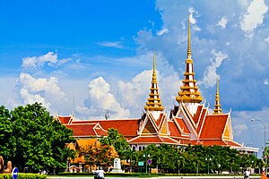
Country:
 Cambodia
Region:
City:
Latitude and Longitude:
Time Zone:
Postal Code:
IP information under different IP Channel
ip-api
Country
Region
City
ASN
Time Zone
ISP
Blacklist
Proxy
Latitude
Longitude
Postal
Route
IPinfo
Country
Region
City
ASN
Time Zone
ISP
Blacklist
Proxy
Latitude
Longitude
Postal
Route
MaxMind
Country
Region
City
ASN
Time Zone
ISP
Blacklist
Proxy
Latitude
Longitude
Postal
Route
Luminati
Country
KHASN
Time Zone
Asia/Phnom_Penh
ISP
WiCAM Corporation Ltd.
Latitude
Longitude
Postal
db-ip
Country
Region
City
ASN
Time Zone
ISP
Blacklist
Proxy
Latitude
Longitude
Postal
Route
ipdata
Country
Region
City
ASN
Time Zone
ISP
Blacklist
Proxy
Latitude
Longitude
Postal
Route
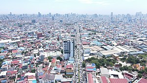
Popular places and events near this IP address

Tuol Sleng Genocide Museum
Museum dedicated to the Cambodian Genocide
Distance: Approx. 1653 meters
Latitude and longitude: 11.54944444,104.91777778
The Tuol Sleng Genocide Museum (Khmer: សារមន្ទីរឧក្រិដ្ឋកម្មប្រល័យពូជសាសន៍ទួលស្លែង, romanized: Saromontir Ukredth Kamm Braly Pouchsasa Tuol Sleng), or simply Tuol Sleng (Khmer: ទួលស្លែង, Tuŏl Slêng [tuəl slaeŋ]; lit. "Hill of the Poisonous Trees" or "Strychnine Hill"), is a museum chronicling the Cambodian genocide. Located in Phnom Penh, the site is a former secondary school which was used as Security Prison 21 (S-21; Khmer: មន្ទីរស-២១) by the Khmer Rouge regime from 1975 until its fall in 1979.

Khan Dangkao
District in Phnom Penh, Cambodia
Distance: Approx. 1185 meters
Latitude and longitude: 11.54340167,104.92410917
Dangkao (Khmer: ដង្កោ) is a district (khan) in the southern part of Phnom Penh, Cambodia. The district is subdivided into 13 sangkats and 83 kroms. The district has an area of 197.89 km2.
Khan Chamkar Mon
District in Phnom Penh, Cambodia
Distance: Approx. 1185 meters
Latitude and longitude: 11.54340167,104.92410917
Chamkar Mon (Khmer: ចំការមន, meaning 'Mulberry Farm') is the southernmost district in central Phnom Penh, Cambodia. The district has an area of 10.56 km2. As of the 2019 census, its population was 70,772.
Khan Mean Chey
District in Phnom Penh, Cambodia
Distance: Approx. 1597 meters
Latitude and longitude: 11.5206,104.9148
Mean Chey (Khmer: មានជ័យ, Méanchei [miəncəj], lit. "Victorious") is an administrative district (khan) located in the south-eastern part of Phnom Penh, Cambodia. As of 2019, due to boundary changes, its population decreased from 2008 but is the second most populous district of Phnom Penh.
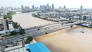
Monivong Bridge
Bridge in Phnom Penh, Cambodia
Distance: Approx. 1668 meters
Latitude and longitude: 11.53130556,104.93291667
Monivong Bridge (Khmer: ស្ពានព្រះមុនីវង្ស) is a heavily trafficked bridge in Phnom Penh, Cambodia. It bridges the Bassac River near the end of National Highway 2 to southern Cambodia and lies along the National Highway 1 which connects the city to eastern Cambodia and Vietnam. On the eastern shore lies the Chhba Ampeou Market.
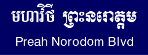
Norodom Boulevard
Boulevard in Phnom Penh, Cambodia
Distance: Approx. 1402 meters
Latitude and longitude: 11.54277778,104.92777778
Norodom Boulevard (Khmer: មហាវិថីព្រះនរោត្តម), also called Street 41 (Khmer: ផ្លូវលេខ៤១), is a major boulevard in Cambodia and one of Phnom Penh's oldest arterial roads. It was named after King Norodom. It connects with Monivong Bridge in the south-east of the city at the Bassac River and joins with the north of the city at Wat Phnom.
Ministry of Culture and Fine Arts (Cambodia)
Distance: Approx. 1257 meters
Latitude and longitude: 11.532644,104.929354
The Ministry of Culture and Fine Arts (MCFA; Khmer: ក្រសួងវប្បធម៌ និងវិចិត្រសិល្បៈ, UNGEGN: Krâsuŏng Vôbbâthôrm nĭng Vĭchĕtr Sĕlbă) is the government ministry with a mandate to promote, encourage and support the fine arts of Cambodia.

Khmer–Soviet Friendship Hospital
Hospital in Youtheapol Khemarak Phumin Blvd , Phnom Penh
Distance: Approx. 1903 meters
Latitude and longitude: 11.544837,104.904022
The Khmer–Soviet Friendship Hospital (KSFH; Khmer: មន្ទីរពេទ្យមិត្តភាពខ្មែរ-សូវៀត, Môntirpéty Mĭttâphéap Khmêr-Soviĕt) is a public hospital located in Phnom Penh, capital of Cambodia. The hospital is currently managed by the Ministry of Health.
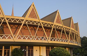
Chaktomuk Conference Hall
Theatre located in Phnom Penh, Cambodia
Distance: Approx. 1176 meters
Latitude and longitude: 11.5442,104.9135
The Chaktomuk Conference Hall (Khmer: សាលសន្និសីទចតុមុខ, Sal Sânnĭsit Châtŏmŭkh) is a theatre located in the city of Phnom Penh, Cambodia. The fan-shaped hall is one of the most iconic works of famous Cambodian architect Vann Molyvann and was since its construction in 1961 one of the "landmarks and infrastructures of the newly independent nation". Mainly used for the purpose of conducting ceremonies for foreign governors, the hall is a designed concrete structure which radiates in a fan shape referencing a palm leaf.
Khan Chroy Changvar
Satellite city in Phnom Penh
Distance: Approx. 1185 meters
Latitude and longitude: 11.54340167,104.92410917
Chroy Changvar (Khmer: ជ្រោយចង្វារ) is a satellite city in Phnom Penh, Cambodia.

Khan Boeng Keng Kang
Section in Phnom Penh, Cambodia
Distance: Approx. 1514 meters
Latitude and longitude: 11.548,104.9156
Boeng Keng Kang (Khmer: បឹងកេងកង [ɓəŋ keːŋkɑːŋ]) is a section (khan) in Phnom Penh, Cambodia. This khan was created on January 8, 2019, according to sub-decree 03 អនក្រ.បក by taking 7 quarters (sangkat) from Chamkar Mon Section. It has a population of 66,658.
Wat Svay Pope
Buddhist monastery in Cambodia
Distance: Approx. 2230 meters
Latitude and longitude: 11.55014,104.9309
Wat Svay Pope (Khmer: វត្តស្វាយពពែ) is a Theravada Buddhist temple located in Phnom Penh, Cambodia, and built in 1929.
Weather in this IP's area
overcast clouds
26 Celsius
27 Celsius
26 Celsius
26 Celsius
1003 hPa
85 %
1003 hPa
1002 hPa
10000 meters
3.81 m/s
9.32 m/s
223 degree
94 %
05:49:34
17:58:03